We Recommend:
Bach Steel - Experts at historic truss bridge restoration.
BridgeHunter.com Phase 1 is released to the public! - Visit Now
KH-2 Westbound Fairchild Creek Bridge
Colborne Street Bridge

Primary Photographer(s): Nathan Holth
Bridge Documented: December 23, 2012
Colborne Street (CR-53 and CR-2) (Westbound Lanes) Over Fairchild Creek
Rural: Brant County, Ontario: Canada
Not Available or Not Applicable
101.7 Feet (31 Meters)
Not Available
23.6 Feet (7.19 Meters)
1 Main Span(s)
Not Applicable

View Information About HSR Ratings
Bridge Documentation
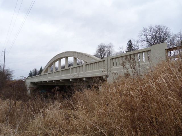
This bridge is a beautiful example of the standard rainbow arch bridges (also called concrete bowstring bridges) that Ontario built on its King's Highway system. The bridge includes the distinctive balustrade railings on the concrete sidewalk, and the arches with the pattern of inset rectangles. This bridge has been sensitively rehabilitated. It appears that the deck and the arch hangers were replaced, but the arch ribs and tie (bottom chord) remain original. This bridge is one of the few provincially-designed rainbow arch bridges that has been rehabilitated and preserved. The bridge was originally built as a two-way bridge, but today serves only westbound traffic, with a newer bridge carrying eastbound traffic. This solution of a one-way couplet of bridges is an excellent way to preserve heritage bridges that fail to provide enough lanes for traffic on their own.
Information and Findings From Canada's Historic PlacesDescription of Historic Place The Brant Bowstring Bridge spans the Grand River on Colborne Street East between Brant Avenue in Brantford and Gilkison Street in the County of Brant. The property consists of a single-span concrete bowstring
arch bridge that was constructed in 1931. Heritage Value The Brant Bowstring Bridge is the only bowstring arch bridge in the County of Brant. Spanning the Grand River on Colborne Street East at the boundary between the City of Brantford and the County of Brant it
serves as a gateway marker. Built in 1931 of reinforced concrete, it was part of the Ontario Governments upgrading of transportation networks after World War I to accommodate the increasing number of automobiles in the area. The
bridge's bowstring design was popular in the 1920s and 1930s as it required minimal material, was simple to install and could easily accommodate vehicular traffic. Character-Defining Elements Character defining elements that contribute to the heritage value include its: Heritage Designation and Type: Municipal Heritage Designation (Part IV) |
![]()
Photo Galleries and Videos: KH-2 Westbound Fairchild Creek Bridge
Bridge Photo-Documentation
Original / Full Size PhotosA collection of overview and detail photos. This gallery offers photos in the highest available resolution and file size in a touch-friendly popup viewer.
Alternatively, Browse Without Using Viewer
![]()
Bridge Photo-Documentation
Mobile Optimized PhotosA collection of overview and detail photos. This gallery features data-friendly, fast-loading photos in a touch-friendly popup viewer.
Alternatively, Browse Without Using Viewer
![]()
Maps and Links: KH-2 Westbound Fairchild Creek Bridge
Coordinates (Latitude, Longitude):
Search For Additional Bridge Listings:
Additional Maps:
Google Streetview (If Available)
GeoHack (Additional Links and Coordinates)
Apple Maps (Via DuckDuckGo Search)
Apple Maps (Apple devices only)
Android: Open Location In Your Map or GPS App
Flickr Gallery (Find Nearby Photos)
Wikimedia Commons (Find Nearby Photos)
Directions Via Sygic For Android
Directions Via Sygic For iOS and Android Dolphin Browser

