We Recommend:
Bach Steel - Experts at historic truss bridge restoration.
BridgeHunter.com Phase 1 is released to the public! - Visit Now
Royal Military College Bridge
Kingston Bailey Bridge

Primary Photographer(s): Nathan Holth and Rick McOmber
Bridge Documented: July 20, 2013
Kingston: Frontenac County, Ontario: Canada
2004
Not Available
Not Available
Not Available
1 Main Span(s)
Not Applicable

View Information About HSR Ratings
Bridge Documentation
View Early Civilian Articles About Bailey Truss Bridges
View A Historical Article About Bailey Bridges
View The United States Army Manual For Bailey Bridges
View The Patent For Bailey Bridges
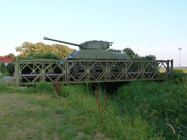
This bridge was erected here in 2004 at the Royal Military College of Canada as an interpretive exhibit. A tank was placed on top of the bridge, demonstrating the load-bearing capabilities of the bridge. The bridge display is an outstanding place to learn about Bailey bridges due to the interpretive signage at the location, and also the fact that the bridge appears to be a genuine World War II era Bailey bridge. Many Bailey bridges seen today do not date from the World War II period, and lack heritage value. These later examples may lack some of the original details of the Bailey bridges used during wartime. This bridge however appears to be from the wartime era. The United States Army Manual for Bailey Bridges is a good resource for identifying details in Bailey bridges.
Steel on the bridge shows brands from a number of British steel mills indicating it is a British-manufactured bridge. Some of the steel has 1945 on it, suggesting the bridge was manufactured in 1945. Most of the details expected in a proper wartime Bailey truss are present, including transoms (floor beams) and the transom clamps that look like c-clamps and hold the transoms in place. Other typical Bailey details are in place. The bridge includes rakers that in the case of this double truss single story Bailey bridge run at a diagonal path between the pairs of trusses on each side of the roadway. Bracing frames span between the pairs of truss lines on each side. The sway bracing (rods with turnbuckles) are present as originally designed, appearing as rods running between corners of the transoms. The end posts retain original design, including jacking step and bearings as outlined in the army manual. The top of some of the end posts has "MkII" welded on it. This appears to refer to the model of the Bailey truss, "Mark 2" which appears to also be referred to as "M2" in some sources.
![]()
Photo Galleries and Videos: Royal Military College Bridge
Bridge Photo-Documentation
Original / Full Size PhotosA collection of overview and detail photos. This gallery offers photos in the highest available resolution and file size in a touch-friendly popup viewer.
Alternatively, Browse Without Using Viewer
![]()
Bridge Photo-Documentation
Mobile Optimized PhotosA collection of overview and detail photos. This gallery features data-friendly, fast-loading photos in a touch-friendly popup viewer.
Alternatively, Browse Without Using Viewer
![]()
Maps and Links: Royal Military College Bridge
Coordinates (Latitude, Longitude):
Search For Additional Bridge Listings:
Additional Maps:
Google Streetview (If Available)
GeoHack (Additional Links and Coordinates)
Apple Maps (Via DuckDuckGo Search)
Apple Maps (Apple devices only)
Android: Open Location In Your Map or GPS App
Flickr Gallery (Find Nearby Photos)
Wikimedia Commons (Find Nearby Photos)
Directions Via Sygic For Android
Directions Via Sygic For iOS and Android Dolphin Browser

