

View Information About HSR Ratings
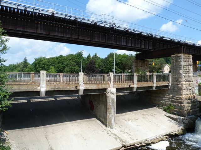
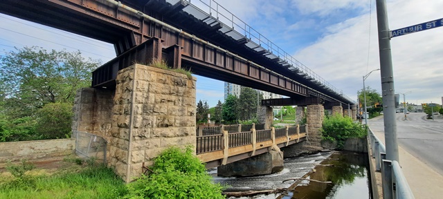
This is a bridge in a most unusual location. It was built directly beneath a railway bridge, allowing Macdonell Street to cross the Speed River directly under the railway. Macdonell Street approached the bridge by passing between the stone columns of the railway bridge. Today, this bridge has been abandoned, having been bypassed by a new bridge directly to the west.
It is not known exactly when this bridge was constructed. The Grand River Heritage Bridge Inventory lists a ca. 1930 construction date. Knowing the exact date would be important for this bridge, because it uses a railing panel design that was used often in Ontario. However, in neighboring Michigan a suspiciously similar railing panel design was also used, suggesting that Michigan and Ontario perhaps got ideas for bridge railing design from one another. This bridge is unusual however because its concrete railing posts have a different inset design in them from most Ontario bridges with this railing panel design. Interestingly however, the railing posts on this bridge are similar to the earliest railing posts coupled with this railing panel design found on Michigan bridges built between 1932 and 1939. The big mystery is who invented the railing design first, Ontario or Michigan? Read more about the railing design here. If it can be proven that this bridge was built before 1932, it would suggest that Ontario came up with the railing design first. In regards to Ontario's use of the railing design, this bridge's metal panels differ slightly from the design of the later bridges using this railing design in that the top of the metal panels is composed of pipe, rather than a custom-shaped design found on later bridges.
This bridge is tagged with the following special condition(s): Unorganized Photos
![]()
![]()
![]()
![]()
![]()
Coordinates (Latitude, Longitude):
Search For Additional Bridge Listings:
Additional Maps:
Google Streetview (If Available)
GeoHack (Additional Links and Coordinates)
Apple Maps (Via DuckDuckGo Search)
Apple Maps (Apple devices only)
Android: Open Location In Your Map or GPS App
Flickr Gallery (Find Nearby Photos)
Wikimedia Commons (Find Nearby Photos)
Directions Via Sygic For Android
Directions Via Sygic For iOS and Android Dolphin Browser

© Copyright 2003-2026, HistoricBridges.org. All Rights Reserved. Disclaimer: HistoricBridges.org is a volunteer group of private citizens. HistoricBridges.org is NOT a government agency, does not represent or work with any governmental agencies, nor is it in any way associated with any government agency or any non-profit organization. While we strive for accuracy in our factual content, HistoricBridges.org offers no guarantee of accuracy. Information is provided "as is" without warranty of any kind, either expressed or implied. Information could include technical inaccuracies or errors of omission. Opinions and commentary are the opinions of the respective HistoricBridges.org member who made them and do not necessarily represent the views of anyone else, including any outside photographers whose images may appear on the page in which the commentary appears. HistoricBridges.org does not bear any responsibility for any consequences resulting from the use of this or any other HistoricBridges.org information. Owners and users of bridges have the responsibility of correctly following all applicable laws, rules, and regulations, regardless of any HistoricBridges.org information.
![]()