We Recommend:
Bach Steel - Experts at historic truss bridge restoration.
BridgeHunter.com Phase 1 is released to the public! - Visit Now
Macdonell Street Railway Bridge
Allan's Bridge

Primary Photographer(s): Nathan Holth and Rick McOmber
Bridge Documented: July 19, 2013 and May 24, 2021
Railroad (Canadian Pacific) Over Speed River and Elizabeth Street
Guelph: Wellington County, Ontario: Canada
1948 By Builder/Contractor: Canadian Bridge Company of Walkerville, Ontario
Not Available or Not Applicable
Not Available
Not Available
Not Available
7 Main Span(s)
Not Applicable

View Information About HSR Ratings
Bridge Documentation
This bridge's future is at risk!
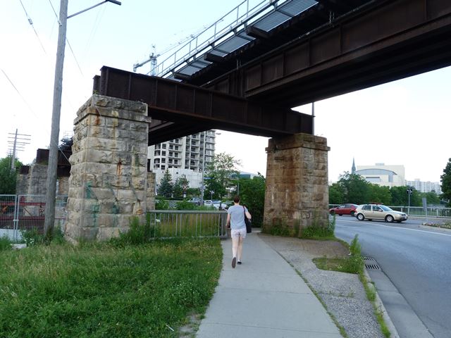
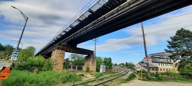
Bridge Status: Slated for demolition and replacement as part of a Metrolinx project to expand Go service.This is a bridge in a most unusual location. It was built directly above Macdonell Street to cross the Speed River directly over Macdonell Street. Macdonell Street approached the bridge by passing between the stone columns of the railway bridge. Today, this Macdonell Street Bridge has been abandoned, having been bypassed by a new bridge directly to the west. However, this railway bridge retains the unusual design needed to accommodate this design. The substructure consists of bents that are composed of a pair of stone columns. On top of these columns rests a built-up steel cap beam that spans between the two columns. This creates a gap under the bridge for the street. The bridge has stone abutments. The width of the abutments are twice as wide as the single track deck plate girder superstructure present at this bridge. This indicates the substructure was originally designed to accommodate a widening of the bridge to a double-track bridge. Additional plate girders would have been added beside the existing ones. Many railways designed bridges like this, but later never found the need to make the expansion to a double track format.
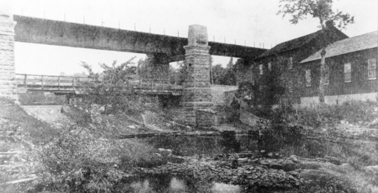
The Grand River Heritage Bridge Inventory suggests the bridge was built in ca. 1857. This is incorrect as a 1948 plaque was found on the superstructure. It is possible however, that the stone abutments and columns date from this period. Substructures were often reused when the superstructure was replaced. However it should be noted that the steel cap beams on the stone columns appear to date to the same 1948 date as the superstructure. The below photo was taken 1887 and shows the previous bridge at this location. It appears to have also been a deck plate girder. The design of the cap beam is not clear in the photo. However, the stone columns look like they could be the same columns, albeit with some sort of decorative extension on top which no longer remains. Photo Source: Guelph Public Library Item Number F38-0-15-0-0-275

This bridge is tagged with the following special condition(s): Unorganized Photos
![]()
Photo Galleries and Videos: Macdonell Street Railway Bridge
Bridge Photo-Documentation
Original / Full Size PhotosA collection of overview and detail photos. This gallery offers photos in the highest available resolution and file size in a touch-friendly popup viewer.
Alternatively, Browse Without Using Viewer
![]()
Bridge Photo-Documentation
Mobile Optimized PhotosA collection of overview and detail photos. This gallery features data-friendly, fast-loading photos in a touch-friendly popup viewer.
Alternatively, Browse Without Using Viewer
![]()
Additional Unorganized Photos
Original / Full Size PhotosA supplemental collection of photos that are from additional visit(s) to the bridge and have not been organized or captioned. This gallery offers photos in the highest available resolution and file size in a touch-friendly popup viewer.
Alternatively, Browse Without Using Viewer
![]()
Additional Unorganized Photos
Mobile Optimized PhotosA supplemental collection of photos that are from additional visit(s) to the bridge and have not been organized or captioned. This gallery features data-friendly, fast-loading photos in a touch-friendly popup viewer.
Alternatively, Browse Without Using Viewer
![]()
Maps and Links: Macdonell Street Railway Bridge
Coordinates (Latitude, Longitude):
Search For Additional Bridge Listings:
Additional Maps:
Google Streetview (If Available)
GeoHack (Additional Links and Coordinates)
Apple Maps (Via DuckDuckGo Search)
Apple Maps (Apple devices only)
Android: Open Location In Your Map or GPS App
Flickr Gallery (Find Nearby Photos)
Wikimedia Commons (Find Nearby Photos)
Directions Via Sygic For Android
Directions Via Sygic For iOS and Android Dolphin Browser


