We Recommend:
Bach Steel - Experts at historic truss bridge restoration.
BridgeHunter.com Phase 1 is released to the public! - Visit Now
Hudson Bridge

Primary Photographer(s): Nathan Holth and Rick McOmber
Bridge Documented: July 20, 2013
Gananoque: Leeds and Grenville United Counties, Ontario: Canada
By Builder/Contractor: Unknown
Not Available or Not Applicable
125.0 Feet (38.1 Meters)
125.0 Feet (38.1 Meters)
Not Available
1 Main Span(s)
Not Applicable

View Information About HSR Ratings
Bridge Documentation
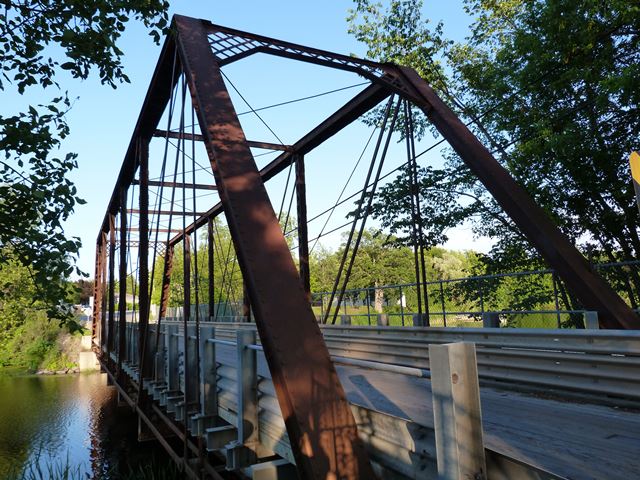
This bridge is a rare example of a pin-connected truss bridge in Ontario. This once common bridge type is rare thanks to demolition and replacement of these bridges, despite their heritage value as some of the oldest metal bridges in Ontario. This bridge is particularly special as it appears to have a rich history. The bridge was apparently originally a railway bridge and may have been relocated to its current location before being converted for vehicular use. The postcard to the right shows what is pretty clearly the same bridge. The bridge is labeled as the "T. I. R. R." Bridge which may mean "Thousand Islands Rail Road" This is evidence that the bridge was originally a railway bridge, and this theory is also further supported by the bridge's unusually large floor beams and narrow roadway width. In the postcard to the right, a dam is shown in the background. There is no dam around the bridge today, but there is a dam (and what appears to be a former railway line) a short distance south of the bridge's current location. The bridge may have originally been located there and later moved here to Machar Street to serve as a highway bridge.
The bridge's trusses appear to retain good historic integrity with no major alterations noted. The heavy floor beams are connected to the truss via an uncommon pin connection to the vertical member, these connections being separate from the bottom chord connections. This design is in contrast to the traditional system of u-bolt hangers that would have extended down from the bottom chord connections to hold the floor beam. The unusual, perhaps more rigid and heavy duty, method of holding the floor beams may be yet more evidence of this bridge's railway past.
![]()
Photo Galleries and Videos: Hudson Bridge
Bridge Photo-Documentation
Original / Full Size PhotosA collection of overview and detail photos. This gallery offers photos in the highest available resolution and file size in a touch-friendly popup viewer.
Alternatively, Browse Without Using Viewer
![]()
Bridge Photo-Documentation
Mobile Optimized PhotosA collection of overview and detail photos. This gallery features data-friendly, fast-loading photos in a touch-friendly popup viewer.
Alternatively, Browse Without Using Viewer
![]()
CarCam: Westbound Crossing
Full Motion VideoNote: The downloadable high quality version of this video (available on the video page) is well worth the download since it offers excellent 1080 HD detail and is vastly more impressive than the compressed streaming video. Streaming video of the bridge. Also includes a higher quality downloadable video for greater clarity or offline viewing.
![]()
CarCam: Eastbound Crossing
Full Motion VideoNote: The downloadable high quality version of this video (available on the video page) is well worth the download since it offers excellent 1080 HD detail and is vastly more impressive than the compressed streaming video. Streaming video of the bridge. Also includes a higher quality downloadable video for greater clarity or offline viewing.
![]()
Maps and Links: Hudson Bridge
Coordinates (Latitude, Longitude):
Search For Additional Bridge Listings:
Additional Maps:
Google Streetview (If Available)
GeoHack (Additional Links and Coordinates)
Apple Maps (Via DuckDuckGo Search)
Apple Maps (Apple devices only)
Android: Open Location In Your Map or GPS App
Flickr Gallery (Find Nearby Photos)
Wikimedia Commons (Find Nearby Photos)
Directions Via Sygic For Android
Directions Via Sygic For iOS and Android Dolphin Browser


