The longest railway bridge in Ontario when completed, this high level deck plate girder bridge, today a trail, is the final crossing before the river enters Lake Huron. Trains stopped running on the bridge in 1988
The Menesetung Bridge spans the Maitland River near
its entry into Lake Huron, connecting the Town of Goderich and the
Township of Ashfield-Colborne-Wawanosh. The seven-span steel and wood
railway bridge was constructed between 1906 and 1907.
The
property was designated by the Town of Goderich in 1993 for its
architectural and historical significance under Part IV of the Ontario
Heritage Act (By-law 90 of 1993).
Heritage Value
Located within the harbour area of the Town of
Goderich, the Menesetung Bridge is a visual reminder of the important
role of Lake Huron and the railway to the development of Goderich. The
harbour and the train station, located to the south of the bridge, were
the industrial and commercial hub of early Goderich and greatly
contributed to the success of the town.
The Menesetung Bridge was
vital to the development of Goderich as a thriving port town. The train
service which crossed the Maitland River via the Menesetung Bridge on
the Canadian Pacific Railway (CPR) Guelph-Goderich Line brought business
and passengers to the harbour town and, through their commerce and
trade, Goderich flourished. The construction, which began in 1906 by
M.A. Pigott of Hamilton, was often delayed due to disputes with the
competing Grand Trunk Railway (GTR).
The Menesetung Bridge's
official opening ceremonies took place on September 19, 1907 and the
bridge served the Town of Goderich and the CPR for over 80 years. In
1988, the final CPR train stopped on the bridge and blew its whistle for
a final time. Today, due in large part to the efforts of the local
community to save the bridge when it was threatened in the early 1990s,
the Menesetung Bridge serves as a pedestrian bridge as part of the
Maitland Trail.
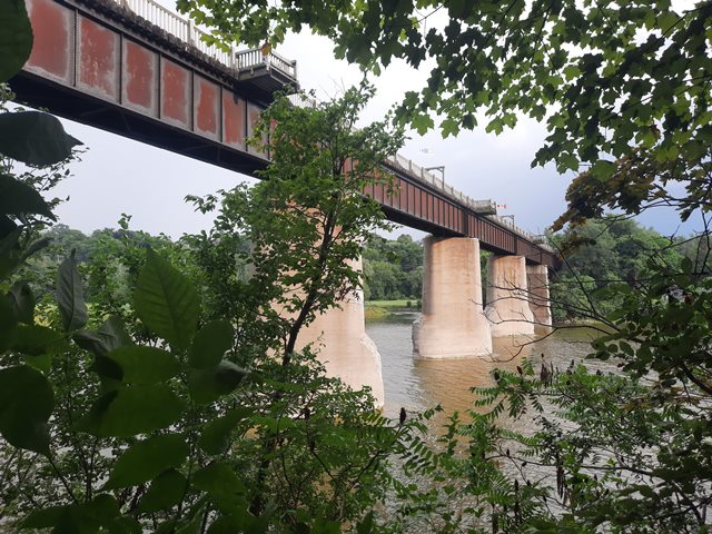
The Menesetung Bridge was the longest bridge in
Ontario at the time of its construction and is a fine example of a
typical Canadian Pacific Rail bridge. The seven spans each measure 104
feet in length and 12 feet in width, creating a total length of 750
feet. The bridge is held up by 2 abutments and 6 concrete piers which
rise about 60 metres from the Maitland River. The embankments were
reinforced with millions of tons of earth, which also reduced the grade
from the Township of Colborne into the Goderich Harbour.
Sources:
Town of Goderich By-law 90 of 1993; Bridge to the Past: A History of the
Menesetung Bridge, Ryerson Neal, 2007.
Character-Defining Elements
Character defining elements that contribute to the
heritage value of the Stone Road Bridge include its: - location
spanning the Maitland River, in close proximity to Goderich Harbour and
the former Goderich CPR station - views to the bridge from the banks
of the Menestung River and the Harbour area - steel and wood
construction - original dimensions of the bridge including seven 104
foot spans and 12 foot width - six concrete piers - two abutments
- reinforced embankments
Heritage Designation and Type: Yes
This bridge is tagged with the following special condition(s): Unorganized Photos
Original / Full Size Photos A collection of overview and detail photos, presented as an unorganized and unlabeled collage and gallery. This gallery offers photos in the highest available resolution and file size in a touch-friendly popup viewer. Alternatively, Browse Without Using Viewer
Mobile Optimized Photos A collection of overview and detail photos, presented as an unorganized and unlabeled collage and gallery. This gallery features data-friendly, fast-loading photos in a touch-friendly popup viewer. Alternatively, Browse Without Using Viewer