

View Information About HSR Ratings
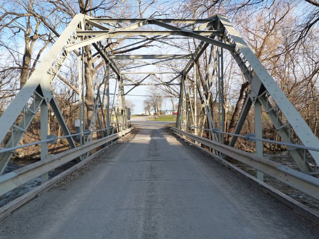
This very short through truss bridge is extremely significant on account of its non-standard unusual construction details and has the potential to be the only example of its kind in existence. Some bridges are "traditionally composed" using construction techniques that were not the unique experimentations or patented details of a particular bridge builder, and instead were "industry standard" methods and materials. Other bridges have many traditionally composed parts, but may have a few specific unusual details. This bridge however is almost completely composed in a non-standard manner. Nearly every aspect of this bridge's trusses are non-standard and unusual. The bridge likely embodies the distinctive experimental construction techniques of a particular bridge builder. Because of the bridge's unique details, as well as the possibility that these details may document the thinking of a particular bridge builder, make this bridge an extremely significant heritage bridge. Further, the bridge may be unique and the last of its kind today due to attrition. For all these reasons, this bridge should be given the highest preservation priority.
The unusual nature of this bridge arises from both the design of the built-up beams on the bridge, as well as the overall truss arrangement and design. The top chord and end post of the bridge in particular is of highly unusual design. The design consists of front-to-front channels connected with v-lacing on each side. The beams are placed such that the v-lacing is positioned on the sides. On the top of this beam a cover plate which is wider than the channel is riveted onto the beam as well. This design is very bizarre. Some bridges have chords that are built-up beams with back-to-back channels (as opposed to the front-to-front on this bridge) with v-lacing, but in those cases, the beams would be placed such that the lacing would be on the top and bottom, not on the sides. Further the addition of a cover plate... and indeed one that is unusually sized to be considerably wider than the channel... is also unusual.
Elsewhere on the bridge, the portal bracing and the overhead lateral bracing being composed of channels is not common. Riveted angles tend to be more common for these elements of a truss. The truss configuration is unusual as well. Overall, the design is a Pratt. However, there are secondary diagonals such as those which would be found on a Baltimore truss. However the bridge lacks the essential secondary subdividing verticals which would branch out from the intersection of these secondary diagonals, so the bridge is not a Baltimore.
All connection fasteners on this bridge are bolted rather than riveted. The built-up beams are all riveted. Instinct would be to assume the bolts are not original and replaced original rivets on the bridge. However given the unusual nature of this bridge it certainly is possible that the bridge always had bolted connections.
The 1907 annual highway report depicts another bridge with these same unusual design details. This bridge is described as "O'Brien's Bridge and was also located in Hastings County. The fact that this bridge, following the same very unusual design, was also located in Hastings County could mean two things. It could suggest that the design was either something the county came up with, or it was the design of a small local bridge company. It also could mean that the Milltown Bridge was actually originally a span of O'Briens Bridge that was salvaged during a bridge replacement project and relocated to the Milltown location. Either way, it does suggest that the Milltown Bridge truss likely dates to the early 20th Century. It is unusual to see such unusual non-standard design details present on a bridge from the early 20th Century. By the early 20th Century experimentation in design for bridges of this size had largely ended in favor of the tried and true standard designs that got the job done effectively both in terms of cost and function.

![]()
![]()
![]()

![]()
![]()
Coordinates (Latitude, Longitude):
Search For Additional Bridge Listings:
Additional Maps:
Google Streetview (If Available)
GeoHack (Additional Links and Coordinates)
Apple Maps (Via DuckDuckGo Search)
Apple Maps (Apple devices only)
Android: Open Location In Your Map or GPS App
Flickr Gallery (Find Nearby Photos)
Wikimedia Commons (Find Nearby Photos)
Directions Via Sygic For Android
Directions Via Sygic For iOS and Android Dolphin Browser

© Copyright 2003-2026, HistoricBridges.org. All Rights Reserved. Disclaimer: HistoricBridges.org is a volunteer group of private citizens. HistoricBridges.org is NOT a government agency, does not represent or work with any governmental agencies, nor is it in any way associated with any government agency or any non-profit organization. While we strive for accuracy in our factual content, HistoricBridges.org offers no guarantee of accuracy. Information is provided "as is" without warranty of any kind, either expressed or implied. Information could include technical inaccuracies or errors of omission. Opinions and commentary are the opinions of the respective HistoricBridges.org member who made them and do not necessarily represent the views of anyone else, including any outside photographers whose images may appear on the page in which the commentary appears. HistoricBridges.org does not bear any responsibility for any consequences resulting from the use of this or any other HistoricBridges.org information. Owners and users of bridges have the responsibility of correctly following all applicable laws, rules, and regulations, regardless of any HistoricBridges.org information.
![]()