We Recommend:
Bach Steel - Experts at historic truss bridge restoration.
BridgeHunter.com Phase 1 is released to the public! - Visit Now
Minto Bridge

Primary Photographer(s): Nathan Holth and Rick McOmber
Bridge Documented: April 13, 2011
Ottawa: Ottawa City, Ontario: Canada
1900 By Builder/Contractor: Dominion Bridge Company of Montréal, Québec
1996
171.0 Feet (52.1 Meters)
Not Available
Not Available
4 Main Span(s)
Not Applicable

View Information About HSR Ratings
Bridge Documentation
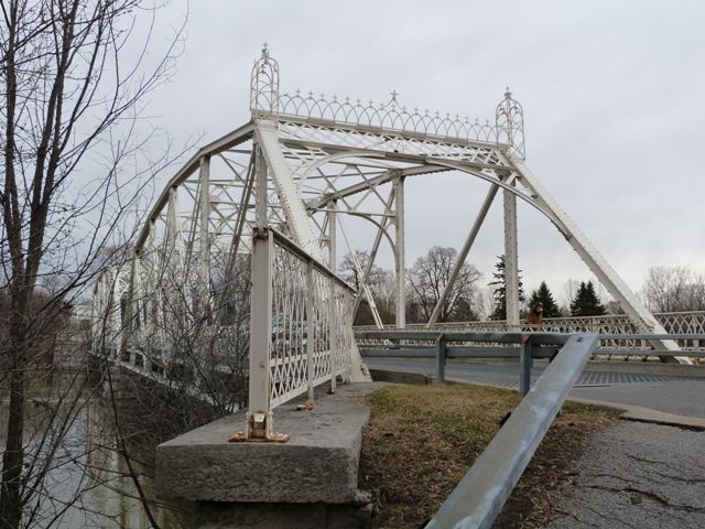
Minto Bridge is a truly special and unique heritage bridge. It is not actually a single bridge, but instead three bridges that connect two small islands to the shores on either side of the Rideau River. Two of the bridges are single span truss bridges. One of the single span bridges connects Maple Island to the shore, and another connects Green Island to the shore. Connecting Green Island to Maple Island is the third bridge, which is a two-span truss bridge. All the spans are the same design and appear to be the same size as well. This unique layout of the bridge makes it an interesting and significant heritage bridge. However several other features add to the significance of the bridge. Constructed in 1900, the bridge has riveted connections making it an early example of this in North America, where pin-connections were far more popular at this date in time. The bridge is ornately decorated in detailed portal cresting and finials. The finials are designed using pieces of cut plate (similar to the portal cresting) rather than some sort of cast iron design which was more common for finials. Further ornamentation comes in the form of the absolutely stunning pedestrian sidewalk railings. The railings follow what HistoricBridges.org calls the "arch lattice railing" design. The extremely rare design varies in exact appearance and is used on a wide variety of bridge types with a variety of construction dates, but they all follow a general architectural style, the origins of which are unknown. The style consists of curved bars arranged along the top 3/4 of the railing panel to form a gothic arch style pattern. The lower 1/4 or so is always devoted to a section of simple lattice.
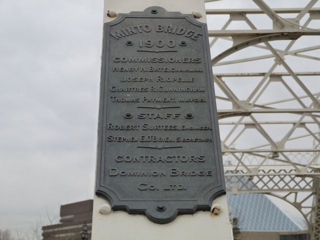
Minto Bridge is named after the fourth earl of Minto who was the eighth governor general of Canada. The bridge has held this name since it was constructed, and it appears on the plaques for this bridge. Interestingly, Lord and Lady Minto were interested in heritage and were involved with the creation of the National Archives of Canada and Lady Minto was involved with the Women's Canadian Historical Society of Ottawa in its first years. Although a new and modern bridge when first built and named after Lord and Lady Minto, today, the Minto Bridge has aged and become a rare and significant heritage bridge, making it an excellent and appropriate memorial to two people who were interested in Canada's heritage.
The bridge is also historically significant for its association with early city improvement and development efforts. The bridge was built under the direction of the Ottawa Improvement Commission which later became the National Capital Commission. It was one of the first projects undertaken by the Ottawa Improvement Commission. Inspired by the beauty and development of Washington, DC, the national capital city in the United States, Wilfred Laurier set up this commission to improve Ottawa and similarly make it a crown jewel of Canada. The construction of this beautifully decorated truss bridge was one of the results of this effort. It was intended to connect the vice-regal residence at Rideau Hall to Parliament Hill. It was thought this route would be of use in various ceremonies. The actual design and construction was supervised by City of Ottawa engineer Robert Surtees. More information here.
Located in Ottawa, a city which has so much beauty and heritage, the importance of preserving this extremely unique, beautiful, and significant heritage bridge cannot be understated. The bridge was rehabilitated in 1996. The bridge remains in good condition, but rust is beginning to peek through the attractive white paint. A spot painting project to halt the progression of this rust might be something to consider in the near future.
This bridge is tagged with the following special condition(s): Arch Lattice Railing
![]()
Photo Galleries and Videos: Minto Bridge
Structure Overview
Original / Full Size PhotosA collection of overview photos that show the bridge as a whole and general areas of the bridge. This gallery offers photos in the highest available resolution and file size in a touch-friendly popup viewer.
Alternatively, Browse Without Using Viewer
![]()
Structure Details
Original / Full Size PhotosA collection of detail photos that document the parts, construction, and condition of the bridge. This gallery offers photos in the highest available resolution and file size in a touch-friendly popup viewer.
Alternatively, Browse Without Using Viewer
![]()
Structure Overview
Mobile Optimized PhotosA collection of overview photos that show the bridge as a whole and general areas of the bridge. This gallery features data-friendly, fast-loading photos in a touch-friendly popup viewer.
Alternatively, Browse Without Using Viewer
![]()
Structure Details
Mobile Optimized PhotosA collection of detail photos that document the parts, construction, and condition of the bridge. This gallery features data-friendly, fast-loading photos in a touch-friendly popup viewer.
Alternatively, Browse Without Using Viewer
![]()
Northbound Crossing
Full Motion VideoStreaming video of the bridge. Also includes a higher quality downloadable video for greater clarity or offline viewing.
![]()
Southbound Crossing
Full Motion VideoStreaming video of the bridge. Also includes a higher quality downloadable video for greater clarity or offline viewing.
![]()
Panning View From Maple Island
Full Motion VideoThis video helps to show how the bridges are positioned in relation to each other. Streaming video of the bridge. Also includes a higher quality downloadable video for greater clarity or offline viewing.
![]()
Maps and Links: Minto Bridge
Coordinates (Latitude, Longitude):
Search For Additional Bridge Listings:
Additional Maps:
Google Streetview (If Available)
GeoHack (Additional Links and Coordinates)
Apple Maps (Via DuckDuckGo Search)
Apple Maps (Apple devices only)
Android: Open Location In Your Map or GPS App
Flickr Gallery (Find Nearby Photos)
Wikimedia Commons (Find Nearby Photos)
Directions Via Sygic For Android
Directions Via Sygic For iOS and Android Dolphin Browser


