

View Information About HSR Ratings
This crossing has an interesting history. Piers and abutments were completed in 1885, designed by famous engineer Charles C. Schneider of St. Louis, Missouri, who was a member of the board of engineers for Pont de Quebec, and was involved with the erection of the Statue of Liberty in New York City in the United States, and also the Niagara Cantilever Bridge over Niagara River near the Falls. In 1905, the Warren truss span was added, replacing one of the previous deck truss spans. In 1910 the rest of the bridge superstructure was replaced.
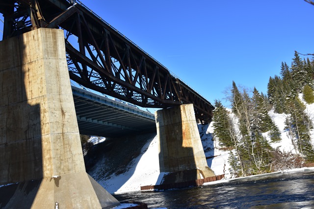
The bridge today is noted for its rare fishbelly deck truss span. Fishbelly deck trusses tended to be used by railroad companies when they wanted to reuse existing piers, but wanted a stronger (and thus deeper) truss span. The fishbelly design provided a deeper truss in the middle of the span, while avoiding the need to alter the piers. The 1885 stone piers were not removed when the existing superstructure was built. The piers today are not recognizable because they appear to have been completely encased in modern concrete. Some of the approach spans appear to have been replaced with modern rolled girder spans, resting on what are assumed to be the 1910 bents.
Bridge lengths given are extremely rough estimates.
It is impossible to not notice the adjacent highway bridge at this location. The first one constructed in 1936 was a deck truss, and was replaced in 1974 with a steel beam bridge. This structure was replaced with the current cable stayed structure in 2015. The bridge failed in early 2016, as the bolts holding the structure down to the bearings failed, resulting in the deck lifting up. This was a massive problem as this is the only structure connecting one half of Canada to the other. If you were traveling all the way across Canada you need to cross this bridge, there is no other way. The bridge has since been repaired and the issue remedied. It is the first cable stayed highway bridge in Ontario.

Above: Historical photo showing previous bridge at this location.

Above: Historical photo showing previous bridge at this location.
This bridge is tagged with the following special condition(s): Fishbelly
![]()
![]()
![]()
Coordinates (Latitude, Longitude):
Search For Additional Bridge Listings:
Additional Maps:
Google Streetview (If Available)
GeoHack (Additional Links and Coordinates)
Apple Maps (Via DuckDuckGo Search)
Apple Maps (Apple devices only)
Android: Open Location In Your Map or GPS App
Flickr Gallery (Find Nearby Photos)
Wikimedia Commons (Find Nearby Photos)
Directions Via Sygic For Android
Directions Via Sygic For iOS and Android Dolphin Browser

© Copyright 2003-2026, HistoricBridges.org. All Rights Reserved. Disclaimer: HistoricBridges.org is a volunteer group of private citizens. HistoricBridges.org is NOT a government agency, does not represent or work with any governmental agencies, nor is it in any way associated with any government agency or any non-profit organization. While we strive for accuracy in our factual content, HistoricBridges.org offers no guarantee of accuracy. Information is provided "as is" without warranty of any kind, either expressed or implied. Information could include technical inaccuracies or errors of omission. Opinions and commentary are the opinions of the respective HistoricBridges.org member who made them and do not necessarily represent the views of anyone else, including any outside photographers whose images may appear on the page in which the commentary appears. HistoricBridges.org does not bear any responsibility for any consequences resulting from the use of this or any other HistoricBridges.org information. Owners and users of bridges have the responsibility of correctly following all applicable laws, rules, and regulations, regardless of any HistoricBridges.org information.
![]()