

View Information About HSR Ratings
This bridge was built as part of a project to built a smallpox quarantine hospital on a Porter Island. The bridge was completed, but construction on the hospital was never finished due to construction flaws and a discovery that the island flooded frequently. The island was instead used as a garbage dump. However another hospital was built on the island (with flood-resistant design) to compact the last major smallpox outbreak in 1920-1921. An article is available here. Note: Bridge lengths given are estimates.

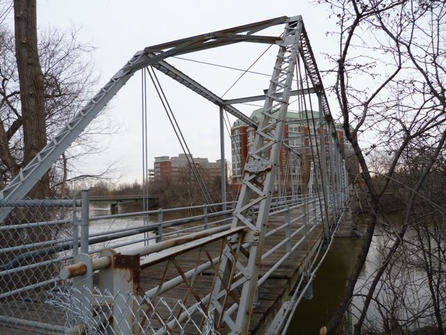
This bridge is an extremely rare example not only of a pin-connected truss bridge in Ontario, but as a multi-span example. It is also noted for its excellent historic integrity with the only noteworthy alteration observed being the replacement of the original lattice railings with pipe railing on the bridge span. Single panels of original lattice railing remains attached to the endposts. The bridge has been bypassed by a modern bridge, but fortunately was not demolished and has been left standing. The bridge has been fenced off to all traffic including pedestrians. The bridge appears to be in decent overall condition, and the only apparent reason for fencing it off appears to be deteriorating wooden deck planks. It would be nice to see this bridge repaired and opened to pedestrian traffic. Ottawa has a number of significant heritage bridges but despite this fact, the bridge is one of the rarest and most significant in the city.
The bridge has marks on some of the metal identifying a mill that would have produced the material, but between the fencing and the fact it was placed on the inside of the built-up beams it is difficult to read. Interestingly however a date that appears to be 1891 appears after the mill name. This may or may not be the same as the construction date of the bridge. An online source lists an 1894 construction date for this bridge. This is plausible, since bridges like this were built from parts that a large bridge company like Dominion would have had stockpiles of, and may have been purchased in advance of actually constructing a particular bridge.
![]()
![]()
![]()
Coordinates (Latitude, Longitude):
Search For Additional Bridge Listings:
Additional Maps:
Google Streetview (If Available)
GeoHack (Additional Links and Coordinates)
Apple Maps (Via DuckDuckGo Search)
Apple Maps (Apple devices only)
Android: Open Location In Your Map or GPS App
Flickr Gallery (Find Nearby Photos)
Wikimedia Commons (Find Nearby Photos)
Directions Via Sygic For Android
Directions Via Sygic For iOS and Android Dolphin Browser

© Copyright 2003-2026, HistoricBridges.org. All Rights Reserved. Disclaimer: HistoricBridges.org is a volunteer group of private citizens. HistoricBridges.org is NOT a government agency, does not represent or work with any governmental agencies, nor is it in any way associated with any government agency or any non-profit organization. While we strive for accuracy in our factual content, HistoricBridges.org offers no guarantee of accuracy. Information is provided "as is" without warranty of any kind, either expressed or implied. Information could include technical inaccuracies or errors of omission. Opinions and commentary are the opinions of the respective HistoricBridges.org member who made them and do not necessarily represent the views of anyone else, including any outside photographers whose images may appear on the page in which the commentary appears. HistoricBridges.org does not bear any responsibility for any consequences resulting from the use of this or any other HistoricBridges.org information. Owners and users of bridges have the responsibility of correctly following all applicable laws, rules, and regulations, regardless of any HistoricBridges.org information.
![]()