We Recommend:
Bach Steel - Experts at historic truss bridge restoration.
BridgeHunter.com Phase 1 is released to the public! - Visit Now
Smiths Falls Bascule Bridge

Primary Photographer(s): Nathan Holth and Rick McOmber
Bridge Documented: July 20, 2013
Smiths Falls: Lanark County, Ontario: Canada
Metal Through Girder, Movable: Single Leaf Bascule (Rolling Lift) and Approach Spans: Metal Through Girder, Fixed
1913 By Builder/Contractor: Dominion Bridge Company of Montréal, Québec and Engineer/Design: Scherzer Rolling Lift Bridge Company of Chicago, Illinois
Not Available or Not Applicable
69.0 Feet (21 Meters)
Not Available
Not Available
1 Main Span(s) and 2 Approach Span(s)
Not Applicable

View Information About HSR Ratings
Bridge Documentation
View A Historical Dominion Bridge Company Catalog
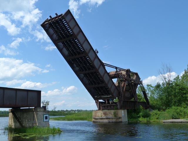
This bridge has been given the highest honor that a heritage bridge in Canada can get, since it is a National Historic Site of Canada, a federal level heritage designation. The bridge is well-deserving, as this is the oldest Scherzer Rolling Lift bascule bridge in Canada. The bridge was built from 1912-1913. It features a plate girder superstructure. The bridge has been abandoned in a raised position. It does not appear to have be fully raised, the bridge would have been capable of raising closer to a ninety degree angle, it is currently raised to closer to a forty-five degree angle. The bridge remains structurally sound, and it is an eye-catching landmark for anyone who is in the area. It is an example of how preservation need not always be expensive, since in this case, merely leaving the bridge standing qualifies as preservation.
It should be noted that the bridge tender house (described below) has been removed.
Information and Findings From Canada's Historic PlacesDescription of Historic Place Smiths Falls Bascule Bridge National Historic Site of Canada is an early movable concrete bridge built in the early twentieth century to carry rail traffic over the Rideau Canal. Located within the town of Smiths Falls, today it stands with its roadbed span permanently raised, its massive counterweight stretching almost perpendicular to the sky, and its adjacent bridge tender's tower unmanned. Heritage Value Smiths Falls Bascule Bridge was designated a national historic site in 1983 because this Scherzer Rolling Lift bascule bridge is an outstanding early example of a novel concept in movable bridges. Character-Defining Elements Key elements that contribute to the heritage value of this site include: Additional Information From Parks Canada The Smiths Falls Bascule Bridge was erected across the Rideau Canal in Smiths Falls between 1912-1913, by the Canadian Northern Railway Company, during the construction of the Toronto-Ottawa section of its
transcontinental main line. Heritage Designation and Type: Yes, National Historic Site of Canada |
![]()
Photo Galleries and Videos: Smiths Falls Bascule Bridge
Bridge Photo-Documentation
Original / Full Size PhotosA collection of overview and detail photos. This gallery offers photos in the highest available resolution and file size in a touch-friendly popup viewer.
Alternatively, Browse Without Using Viewer
![]()
Bridge Photo-Documentation
Mobile Optimized PhotosA collection of overview and detail photos. This gallery features data-friendly, fast-loading photos in a touch-friendly popup viewer.
Alternatively, Browse Without Using Viewer
![]()
Maps and Links: Smiths Falls Bascule Bridge
Coordinates (Latitude, Longitude):
Search For Additional Bridge Listings:
Additional Maps:
Google Streetview (If Available)
GeoHack (Additional Links and Coordinates)
Apple Maps (Via DuckDuckGo Search)
Apple Maps (Apple devices only)
Android: Open Location In Your Map or GPS App
Flickr Gallery (Find Nearby Photos)
Wikimedia Commons (Find Nearby Photos)
Directions Via Sygic For Android
Directions Via Sygic For iOS and Android Dolphin Browser

