

View Information About HSR Ratings

Additional technical facts: The bridge is 29 feet 8 inches (9 meters) from arch exterior to arch exterior and 35 feet 9 inches (10.9 meters) including the cantilever sidewalk. The bridge was rehabilitated in 2001 by Front Construction Industries Inc. and Stantec Consulting Ltd.
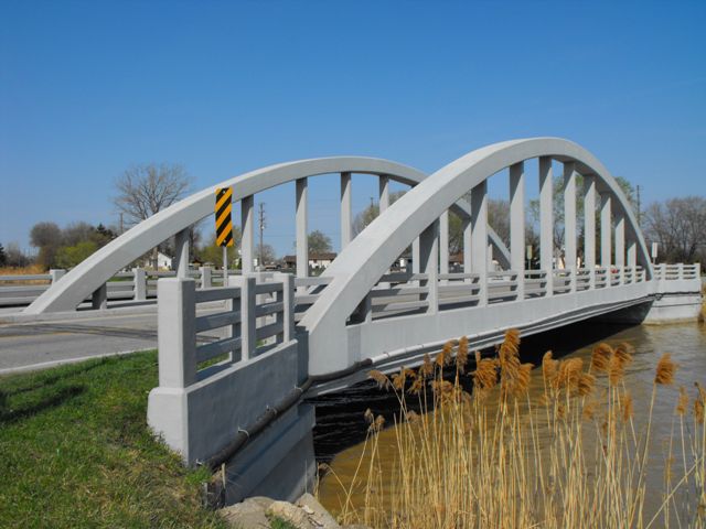
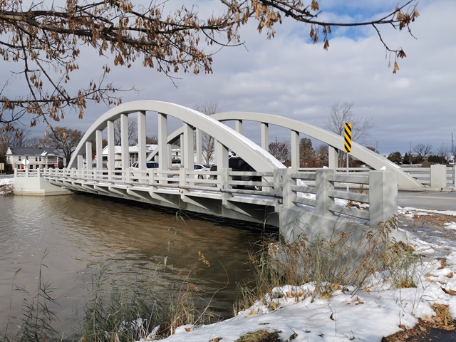
This bridge is the larger of two beautiful concrete bowstring through arch bridges (often called rainbow arch bridges) in Essex County, which are nearby each other. Both bridges are unusual because they do not follow the standard plan seen many other Ontario rainbow arch bridges. This other more common standard plan includes more massive members and arches, and inset rectangles on the arch, and they also have simple concrete balustrade railings. In contrast, the two seen in Essex County contain no inset rectangles, very lightweight members, and their railings are concrete fence railings. Note that despite their extremely lightweight construction, they are not Marsh arches. Exposed reinforcing rods were observed inside the concrete and no evidence of solid built-up beams that would define a Marsh Arch were present.
This bridge, carrying Townline Road (CR-8) over Canard River, provides a crossing directly north of the prominent St. Joseph Church at the small community which was known as River Canard, and was also called Loiselleville for a time. The community is today a part of Amherstburg. The bridge is today a locally recognizable landmark and its image can be seen on the county website.
The River Canard Bridge should be considered an Ontario heritage bridge because the bridge is historically and technologically significant. It is a large span example of a rainbow arch bridge that follows a different design than most rainbow arch bridges in Ontario. The bridge also retains an excellent degree of structural and historic integrity. Further, the bridge is historically significant as a prominent local landmark and a physical part of the River Canard community. Finally, the bridge compliments the heritage and aesthetic value of the nearby St. Joseph Church.
Fortunately, this bridge's heritage value appears to have been recognized by Essex County. The bridge has been beautifully rehabilitated. In the rehabilitation, deteriorated concrete was carefully patched and repaired and the entire bridge was painted with a concrete sealant which protects the concrete and created a uniform appearance and color on the bridge after the concrete had been patched. The deck also appears to have been replaced or heavily repaired. No alterations to the original design and appearance of the bridge are apparent. Original railings are the only railings present on the bridge, located at the edges of the bridge, integrated with the arch on the northeastern arch, and on the cantilevered sidewalk which is present on the southwestern side.
This bridge is tagged with the following special condition(s): Unorganized Photos
![]()
![]()
![]()

![]()
![]()
![]()
Coordinates (Latitude, Longitude):
Search For Additional Bridge Listings:
Additional Maps:
Google Streetview (If Available)
GeoHack (Additional Links and Coordinates)
Apple Maps (Via DuckDuckGo Search)
Apple Maps (Apple devices only)
Android: Open Location In Your Map or GPS App
Flickr Gallery (Find Nearby Photos)
Wikimedia Commons (Find Nearby Photos)
Directions Via Sygic For Android
Directions Via Sygic For iOS and Android Dolphin Browser

© Copyright 2003-2026, HistoricBridges.org. All Rights Reserved. Disclaimer: HistoricBridges.org is a volunteer group of private citizens. HistoricBridges.org is NOT a government agency, does not represent or work with any governmental agencies, nor is it in any way associated with any government agency or any non-profit organization. While we strive for accuracy in our factual content, HistoricBridges.org offers no guarantee of accuracy. Information is provided "as is" without warranty of any kind, either expressed or implied. Information could include technical inaccuracies or errors of omission. Opinions and commentary are the opinions of the respective HistoricBridges.org member who made them and do not necessarily represent the views of anyone else, including any outside photographers whose images may appear on the page in which the commentary appears. HistoricBridges.org does not bear any responsibility for any consequences resulting from the use of this or any other HistoricBridges.org information. Owners and users of bridges have the responsibility of correctly following all applicable laws, rules, and regulations, regardless of any HistoricBridges.org information.
![]()