We Recommend:
Bach Steel - Experts at historic truss bridge restoration.
BridgeHunter.com Phase 1 is released to the public! - Visit Now
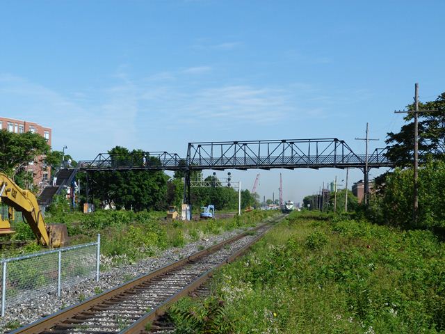
Wallace Avenue Foot Bridge

Primary Photographer(s): Nathan Holth
Bridge Documented: June 20, 2013
Wallace Avenue (Pedestrian Walkway) Over Railroad (Go, Canadian National)
Toronto: Toronto City, Ontario: Canada
1907 By Builder/Contractor: Ontario Bridge Company of Toronto, Ontario
Not Available or Not Applicable
85.0 Feet (25.9 Meters)
Not Available
Not Available
3 Main Span(s)
Not Applicable

View Information About HSR Ratings
Bridge Documentation
This bridge is a rare example of a multi-span pony truss, and also of riveted truss foot bridge. It is listed on the Toronto Inventory of Heritage Properties. It was reported to have been built in 1907 with the trusses built by the Ontario Bridge Company with Frazer Matthews as Chief Engineer. The City of Toronto Works Department apparently constructed the concrete foundations for the bridge. C. H. Rust was the city engineer when the bridge was built. The bridge features steel bents for supports, which rest on top of the concrete footings. The three truss spans include a larger center span that has an unusual skewed design. The southwestern end post is vertical as a result of the skew, while the other three end posts are inclined, although the inclination angle does not appear to be the same for the two at the eastern end, again likely a result of the skewed design. The bridge has experienced moderate alteration from its original design and materials. The stairways do not appear to be original. Some truss members appear to have been replaced, and some rivets appear to have been replaced with bolts.
The below undated photo, presumably taken soon after the bridge's construction, either explains the bridge's history, or adds to the mystery depending on your perspective. In the below photo (click the photo for enlargement) the endposts on the truss spans all appear to have similar inclination, and the nearly-vertical endpost on the center span does not appear to be present. Another photo dated 1915 shows the nearly-vertical end post. This would seem to suggest that one of the bents supporting the trusses was relocated slightly sometime between 1907 and 1915, perhaps to accommodate changes to the track configuration. Moving a single bent without moving anything else would require changing the trusses, such as changing the endpost inclination. Sometime after 1915, another alteration occurred when the bottoms of the steel bents were converted to concrete.
Above: A photo showing the bridge in 1951. Source: virtualreferencelibrary.ca
![]()
Photo Galleries and Videos: Wallace Avenue Foot Bridge
Bridge Photo-Documentation
Original / Full Size PhotosA collection of overview and detail photos. This gallery offers photos in the highest available resolution and file size in a touch-friendly popup viewer.
Alternatively, Browse Without Using Viewer
![]()
Bridge Photo-Documentation
Mobile Optimized PhotosA collection of overview and detail photos. This gallery features data-friendly, fast-loading photos in a touch-friendly popup viewer.
Alternatively, Browse Without Using Viewer
![]()
Maps and Links: Wallace Avenue Foot Bridge
Coordinates (Latitude, Longitude):
Search For Additional Bridge Listings:
Additional Maps:
Google Streetview (If Available)
GeoHack (Additional Links and Coordinates)
Apple Maps (Via DuckDuckGo Search)
Apple Maps (Apple devices only)
Android: Open Location In Your Map or GPS App
Flickr Gallery (Find Nearby Photos)
Wikimedia Commons (Find Nearby Photos)
Directions Via Sygic For Android
Directions Via Sygic For iOS and Android Dolphin Browser


