

View Information About HSR Ratings
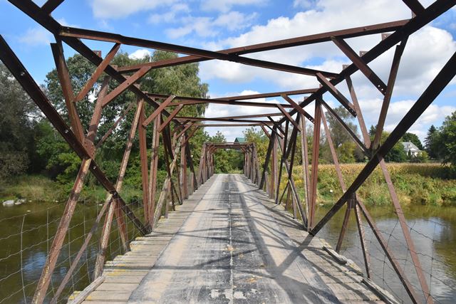
This is one of the most unusual bridges in Ontario and perhaps beyond. It is a bridge pieced together, seemingly randomly without concern for engineering of any kind, from salvaged steel of riveted construction. The bridge consists of two through girder spans at the southern end, and two through truss spans at the northern end. It would be hard to call this a "heritage bridge" yet it is composed of old materials, and is a truly unique structure. It no doubt instills great fear into any engineer.
The girder spans are composed of rolled girders with riveted connections for various beams, most of which were removed when the girders were salvaged. The composition is truly extraordinary. Each girder in the span is itself composed of two girders (of differing size and design) which are crudely welded together from pits of plate at midspan. Moreover, in each span, the girder design/size does not always match the design on the opposite side of the road!
The two truss spans are no less remarkable. It would appear that these truss spans are composed from salvaged roof trusses. The roof trusses are of all-riveted construction, but they were welded together to assemble the truss bridge. Because of the haphazard way in which these trusses were pieced together to form the bridge span, these trusses do not conform to any known truss configuration.
The origin and ownership of the bridge is unknown. Although no signage forbids usage, there is a "dead end" sign that appears next to the last driveway before the bridge, suggesting that public/government ownership ends at this point. Beyond the dead end road sign, the road and bridge might not be owned by the government. The local Mennonite community has been known to build low-budget crossings (the most famous is a nearby concrete low water crossing called the Mennonite Bridge). It is possible that they built and maintain this bridge.
![]()
![]()
![]()
Although no signs forbidding public use were posted, this bridge appears to be privately owned. Cross at your own risk!
Coordinates (Latitude, Longitude):
Search For Additional Bridge Listings:
Additional Maps:
Google Streetview (If Available)
GeoHack (Additional Links and Coordinates)
Apple Maps (Via DuckDuckGo Search)
Apple Maps (Apple devices only)
Android: Open Location In Your Map or GPS App
Flickr Gallery (Find Nearby Photos)
Wikimedia Commons (Find Nearby Photos)
Directions Via Sygic For Android
Directions Via Sygic For iOS and Android Dolphin Browser

© Copyright 2003-2025, HistoricBridges.org. All Rights Reserved. Disclaimer: HistoricBridges.org is a volunteer group of private citizens. HistoricBridges.org is NOT a government agency, does not represent or work with any governmental agencies, nor is it in any way associated with any government agency or any non-profit organization. While we strive for accuracy in our factual content, HistoricBridges.org offers no guarantee of accuracy. Information is provided "as is" without warranty of any kind, either expressed or implied. Information could include technical inaccuracies or errors of omission. Opinions and commentary are the opinions of the respective HistoricBridges.org member who made them and do not necessarily represent the views of anyone else, including any outside photographers whose images may appear on the page in which the commentary appears. HistoricBridges.org does not bear any responsibility for any consequences resulting from the use of this or any other HistoricBridges.org information. Owners and users of bridges have the responsibility of correctly following all applicable laws, rules, and regulations, regardless of any HistoricBridges.org information.
![]()