

View Information About HSR Ratings
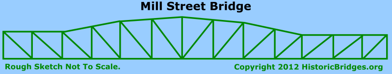
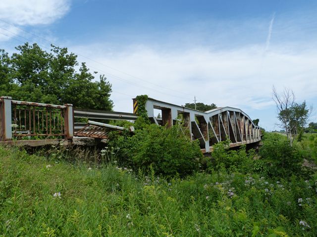
This bridge is a most unusual structure, that may be unique in Ontario. Although it was built in 1959, an era of standardized designs and distinguished by a lack of experimentation, this bridge exhibits numerous highly unusual details. First, as a truss over 50 years old and with welded connections, it is unusual in Ontario. However, the design of the truss is what is most odd. The bridge has been classified as a Parker truss, however, for each of the two truss lines, the top chord for the end panels is not polygonal, but instead maintains a parallel position to the bottom chord. With this unusual design and appearance, one might suspect that the truss is a three span continuous structure, however it is a single simple span. The end post is vertical, another unusual aspect. Furthermore, the 30 degree skew of the bridge has apparently led to the other unusual aspect that the truss configuration is not symmetrical. The end panels with a top chord parallel to the bottom chord is three panels at one end of the truss and only two panels at the other end. For the north truss, the three panel parallel section is at the east end of the bridge, while for the south truss, the three panel section is at the west end. The ends of the bridge each have a single concrete t-beam approach span. The approach spans and abutments are not skewed, only the piers and truss are skewed. Finally, it should be noted that the truss span is 162 feet (49.4 meters) which makes it one of the longest pony truss spans to be found.
This bridge's bottom chord was observed to be covered in large amounts of dirt. Dirt traps moisture and leads to rapid deterioration. A simple program of sending a water truck out to wash truss bridges is a simple, low-cost procedure that can go a long way to increasing the service life of truss bridges.
![]()
![]()
![]()

![]()
![]()
This historic bridge has been demolished. This map is shown for reference purposes only.
Coordinates (Latitude, Longitude):
Search For Additional Bridge Listings:
Additional Maps:
Google Streetview (If Available)
GeoHack (Additional Links and Coordinates)
Apple Maps (Via DuckDuckGo Search)
Apple Maps (Apple devices only)
Android: Open Location In Your Map or GPS App
Flickr Gallery (Find Nearby Photos)
Wikimedia Commons (Find Nearby Photos)
Directions Via Sygic For Android
Directions Via Sygic For iOS and Android Dolphin Browser

© Copyright 2003-2025, HistoricBridges.org. All Rights Reserved. Disclaimer: HistoricBridges.org is a volunteer group of private citizens. HistoricBridges.org is NOT a government agency, does not represent or work with any governmental agencies, nor is it in any way associated with any government agency or any non-profit organization. While we strive for accuracy in our factual content, HistoricBridges.org offers no guarantee of accuracy. Information is provided "as is" without warranty of any kind, either expressed or implied. Information could include technical inaccuracies or errors of omission. Opinions and commentary are the opinions of the respective HistoricBridges.org member who made them and do not necessarily represent the views of anyone else, including any outside photographers whose images may appear on the page in which the commentary appears. HistoricBridges.org does not bear any responsibility for any consequences resulting from the use of this or any other HistoricBridges.org information. Owners and users of bridges have the responsibility of correctly following all applicable laws, rules, and regulations, regardless of any HistoricBridges.org information.
![]()