

View Information About HSR Ratings
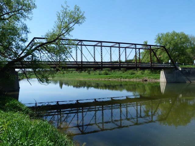
This bridge is a rare surviving example of a pin-connected through truss bridge in Ontario. While the bridge is a traditional example of its type overall, the bridge has several noteworthy unusual details.
The vertical members which are composed of back-to-back channels with lacing have cutouts at the bottom of the channels for the diagonal members of the truss to pass through. Of interest is the cutouts were made by drilling a series of small holes in a line, a technique used to cut metal in the shop before cutting torches were around. Of further interest on this specific bridge is the extremely crude nature of the cutouts. The holes barely line up and do not even form a straight line in many places. Whoever was responsible for making the cutouts when this bridge was fabricated either didn't care about the details or was under the influence! Another interesting detail is that these cutouts are present at the bottom of all the vertical member channels, including ones that do not require and do not have any diagonal members passing through them. This suggests that either nobody thought through which channels would need the cutouts in reality, or the builder simply did not have to worry about it and wanted it so all the verticals would work wherever they were located or positioned.
The bottom chord of the bridge has an unusual detail at the end panels, where rare ribbon lacing (could also be called corrugation) is present. This is a detail that is extremely rare on highway bridges, and is more often found on railway bridges. The exact reasoning for the stiffening of end panel bottom chord in a truss bridge is unclear, however logic suggests that engineers must have expected the end panel bottom chord to perhaps be on occasion be subjected to additional forces beyond that which the rest of the bottom chord would normally experience.
Finally, there is an unusual detail with the hip verticals. The bottom of the hip vertical splits to form a rare double-eye design.
This bridge is in a rural location and is deserving of preservation. The bridge retains integrity of its unusual details and the majority of its original materials. The main alteration noted with the bridge was the replacement of end post and top chord plate, which was originally riveted, with new plate which is bolted on.
![]()
![]()
![]()
This historic bridge has been demolished. This map is shown for reference purposes only.
Coordinates (Latitude, Longitude):
Search For Additional Bridge Listings:
Additional Maps:
Google Streetview (If Available)
GeoHack (Additional Links and Coordinates)
Apple Maps (Via DuckDuckGo Search)
Apple Maps (Apple devices only)
Android: Open Location In Your Map or GPS App
Flickr Gallery (Find Nearby Photos)
Wikimedia Commons (Find Nearby Photos)
Directions Via Sygic For Android
Directions Via Sygic For iOS and Android Dolphin Browser

© Copyright 2003-2025, HistoricBridges.org. All Rights Reserved. Disclaimer: HistoricBridges.org is a volunteer group of private citizens. HistoricBridges.org is NOT a government agency, does not represent or work with any governmental agencies, nor is it in any way associated with any government agency or any non-profit organization. While we strive for accuracy in our factual content, HistoricBridges.org offers no guarantee of accuracy. Information is provided "as is" without warranty of any kind, either expressed or implied. Information could include technical inaccuracies or errors of omission. Opinions and commentary are the opinions of the respective HistoricBridges.org member who made them and do not necessarily represent the views of anyone else, including any outside photographers whose images may appear on the page in which the commentary appears. HistoricBridges.org does not bear any responsibility for any consequences resulting from the use of this or any other HistoricBridges.org information. Owners and users of bridges have the responsibility of correctly following all applicable laws, rules, and regulations, regardless of any HistoricBridges.org information.
![]()