We Recommend:
Bach Steel - Experts at historic truss bridge restoration.
BridgeHunter.com Phase 1 is released to the public! - Visit Now
Martin Street Bridge
Mill Street Bridge

Primary Photographer(s): Nathan Holth
Bridge Documented: October 4, 2016
Wellington North (Mt. Forest): Wellington County, Ontario: Canada
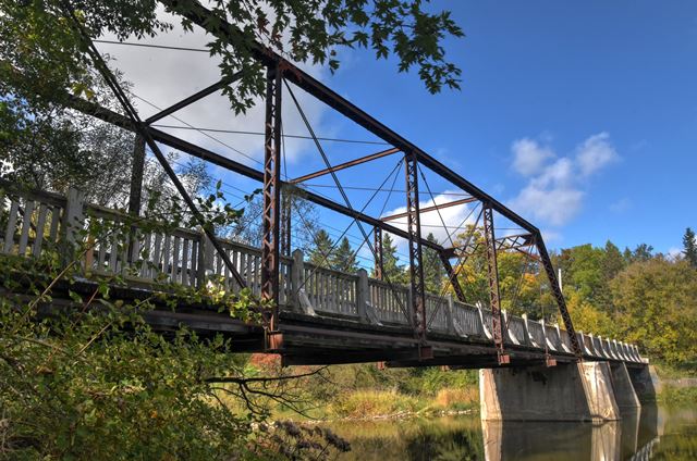
Metal 6 Panel Pin-Connected Pratt Through Truss, Fixed and Approach Spans: Metal Stringer (Multi-Beam), Fixed
By Builder/Contractor: Central Bridge and Engineering Company of Peterborough, Ontario and Engineer/Design: William H. Law of Peterborough, Ontario
Not Available or Not Applicable
Not Available
Not Available
Not Available
1 Main Span(s) and 2 Approach Span(s)
Not Applicable

View Information About HSR Ratings
Bridge Documentation

This bridge is a rare surviving example of a pin-connected truss bridge in Ontario. Although the builder plaque has been mostly destroyed, enough of the distinctive circular channel border remains to be certain that this bridge was the work of the Central Bridge and Engineering Company. Other details associated with the company is the use of unusual cover plate splices about halfway up the endposts, as well as a distintive portal bracing design which switches to plate at the ends with cutouts angled to match the angles of the interior lattice pattern. These two design details are found on multiple bridges by this company. The northern approach spans and the northern concrete substructrues may not be original to the bridge. At the south end of the bridge, the truss is supported by riveted caissons, which likely are original. The caissons are capped with cast iron caps (instead of riveted plate which was more common). Also unusual are the bearings which are also cast iron. Based on other bridges by this company in Ontario, a ca. 1890s construction date seems reasonable. However, the unusual cast iron bearings might suggest this is an earlier bridge, perhaps even dating to the 1880s.
This bridge has been redecked and left in place for non-motorized traffic. There is one area of maintenance concern noted: A tree of substantial size has completely grown around one of the lower chord eyebars. Thought should be given to removing this tree. This bridge is a pin-connected truss bridge that functions best when its connections can flex freely, and the tree may be restricting this, as well as causing additional unknown stresses in the bridge for which it was not designed for.
![]()
Photo Galleries and Videos: Martin Street Bridge
Bridge Photo-Documentation
Original / Full Size PhotosA collection of overview and detail photos. This gallery offers photos in the highest available resolution and file size in a touch-friendly popup viewer.
Alternatively, Browse Without Using Viewer
![]()
Bridge Photo-Documentation
Mobile Optimized PhotosA collection of overview and detail photos. This gallery features data-friendly, fast-loading photos in a touch-friendly popup viewer.
Alternatively, Browse Without Using Viewer
![]()
Maps and Links: Martin Street Bridge
This bridge is on a section of former road that is today intended for non-motorized traffic only as part of a local trail system.
Coordinates (Latitude, Longitude):
Search For Additional Bridge Listings:
Additional Maps:
Google Streetview (If Available)
GeoHack (Additional Links and Coordinates)
Apple Maps (Via DuckDuckGo Search)
Apple Maps (Apple devices only)
Android: Open Location In Your Map or GPS App
Flickr Gallery (Find Nearby Photos)
Wikimedia Commons (Find Nearby Photos)
Directions Via Sygic For Android
Directions Via Sygic For iOS and Android Dolphin Browser

