

View Information About HSR Ratings
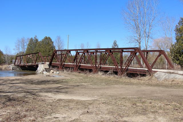
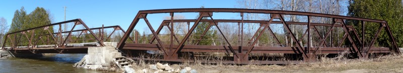
This is a unique bridge. It is quite apparent just from looking at the bridge that two different single truss bridge spans were acquired by this campground and placed here on homemade abutments and pier to form a two-span bridge for the use of campground visitors. The decision to reuse these bridges by the campground likely saved these two heritage bridges from being destroyed and lost forever. Instead, the spans today form a unique and functional bridge, and are an example of how heritage bridges can be preserved while serving a new functional use. As heritage bridges, they also add beauty and history to the campground, something that a modern bridge would have been unable to provide.
The two bridges make an interesting comparison to each other. Although both are rivet-connected Warren pony trusses, each span is quite different. The northern span is a bit shorter, and has four panels, while the longer southern span has five panels. The northern span is a lightweight and simple design, with chords and members composed of simple paired angles. It also has outriggers for stability, which are composed of angle as well. In contrast, the southern span has a heavier and more complex design composed of diagonal members: two angles with battens, vertical members: two angles with lattice bars, top chord: back-to-back channels with cover plate and battens, and finally bottom chord: paired angles. The heavier design, despite being taller, did not need the stabilization of outriggers, and as such has none. Typically, heavier truss bridges suggest a newer bridge, while older bridges tend to have lighter weight construction. Similarly, older bridges tend to have narrower roadways, while newer bridges have wider roadways. However, with these two spans, the heavier southern span has a narrower roadway. The construction date and origin is unknown for both spans.
![]()
![]()
![]()
Note that this bridge is located in a campground and not on a public road. Please respect the rights and rules of the owner.
Coordinates (Latitude, Longitude):
Search For Additional Bridge Listings:
Additional Maps:
Google Streetview (If Available)
GeoHack (Additional Links and Coordinates)
Apple Maps (Via DuckDuckGo Search)
Apple Maps (Apple devices only)
Android: Open Location In Your Map or GPS App
Flickr Gallery (Find Nearby Photos)
Wikimedia Commons (Find Nearby Photos)
Directions Via Sygic For Android
Directions Via Sygic For iOS and Android Dolphin Browser

© Copyright 2003-2025, HistoricBridges.org. All Rights Reserved. Disclaimer: HistoricBridges.org is a volunteer group of private citizens. HistoricBridges.org is NOT a government agency, does not represent or work with any governmental agencies, nor is it in any way associated with any government agency or any non-profit organization. While we strive for accuracy in our factual content, HistoricBridges.org offers no guarantee of accuracy. Information is provided "as is" without warranty of any kind, either expressed or implied. Information could include technical inaccuracies or errors of omission. Opinions and commentary are the opinions of the respective HistoricBridges.org member who made them and do not necessarily represent the views of anyone else, including any outside photographers whose images may appear on the page in which the commentary appears. HistoricBridges.org does not bear any responsibility for any consequences resulting from the use of this or any other HistoricBridges.org information. Owners and users of bridges have the responsibility of correctly following all applicable laws, rules, and regulations, regardless of any HistoricBridges.org information.
![]()