

View Information About HSR Ratings
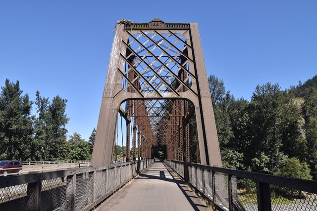
This bridge was originally constructed over the John Day River in north central Oregon for the Oregon Railway and Navigation Company, and relocated and reused by the Southern Pacific Railroad Company here in 1907.
This bridge's lattice portal and sway bracing, Whipple truss configuration, horizontal member that passes through the middle of the end panels, and the bridge's cast iron portal ornamentation and plaques all are distinctive details of famous engineer George Morison. George Morison designed some of the first bridges over major rivers like the Mississippi and Missouri Rivers. Many of these bridges broke records for span length and were among the first large-scale metal bridges in the United States. However, nearly all of these bridges have been demolished and replaced today. Thus this bridge, which was a relatively small project for Morison, is one of the few surviving examples of this very important engineer's work. Despite the smaller size, the bridge contains the general design and appearance that Morison used for his longer spans. The bridge retains excellent historic integrity today and stands out as one of Oregon's most important historic bridges.

Above: Historical photo showing bridge in its original location over the John Day River for the Oregon Railway and Navigation Company.

Former bridge in Bismarck, North Dakota, displaying similar details to the Armitage Bridge.

Former bridge in Nebraska City, Nebraska, displaying similar details to the Armitage Bridge.

Above: Historical drawing for the Nebraska City, Nebraska, displaying similar details to the Armitage Bridge.
![]()
![]()
![]()
Coordinates (Latitude, Longitude):
Search For Additional Bridge Listings:
Bridgehunter.com: View listed bridges within 0.5 miles (0.8 kilometers) of this bridge.
Bridgehunter.com: View listed bridges within 10 miles (16 kilometers) of this bridge.
Additional Maps:
Google Streetview (If Available)
GeoHack (Additional Links and Coordinates)
Apple Maps (Via DuckDuckGo Search)
Apple Maps (Apple devices only)
Android: Open Location In Your Map or GPS App
Flickr Gallery (Find Nearby Photos)
Wikimedia Commons (Find Nearby Photos)
Directions Via Sygic For Android
Directions Via Sygic For iOS and Android Dolphin Browser
USGS National Map (United States Only)
Historical USGS Topo Maps (United States Only)
Historic Aerials (United States Only)
CalTopo Maps (United States Only)

© Copyright 2003-2026, HistoricBridges.org. All Rights Reserved. Disclaimer: HistoricBridges.org is a volunteer group of private citizens. HistoricBridges.org is NOT a government agency, does not represent or work with any governmental agencies, nor is it in any way associated with any government agency or any non-profit organization. While we strive for accuracy in our factual content, HistoricBridges.org offers no guarantee of accuracy. Information is provided "as is" without warranty of any kind, either expressed or implied. Information could include technical inaccuracies or errors of omission. Opinions and commentary are the opinions of the respective HistoricBridges.org member who made them and do not necessarily represent the views of anyone else, including any outside photographers whose images may appear on the page in which the commentary appears. HistoricBridges.org does not bear any responsibility for any consequences resulting from the use of this or any other HistoricBridges.org information. Owners and users of bridges have the responsibility of correctly following all applicable laws, rules, and regulations, regardless of any HistoricBridges.org information.
![]()