

View Information About HSR Ratings
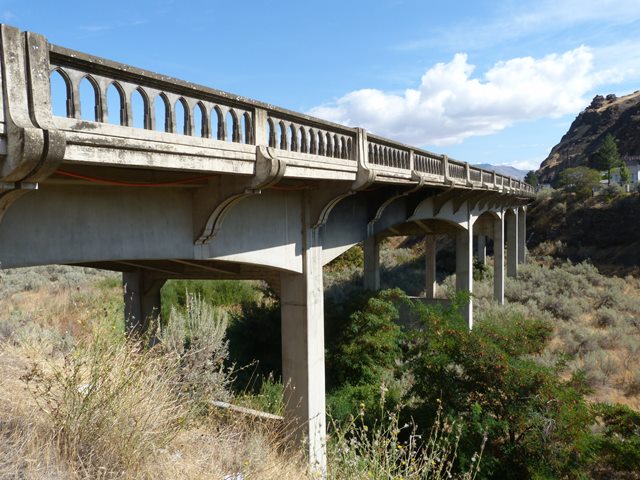
Oregon's historic bridges, especially those associated with famous state engineer Conde McCullough like this bridge have an unusually high level of aesthetic detailing that make them among the most beautiful of their type. This bridge exemplifies that level of aesthetics very well, both because its original details are unaltered, and also because this is a bridge type that in most states was used for mundane bridges with minimal aesthetics, yet here the structure is just as striking as the most ornate of concrete bridges. At the same time, there is evidence of economy in the bridge, since the fascia beams have a smooth, aesthetically pleasing arch shape to them, but the interior beams are not curved.
Information and Findings From Oregon's Historic Bridge InventoryDescription Seven 70-ft reinforced concrete continuous deck girder spans with arched exterior girders and simple haunched interior girders Designer State Highway Department under C.B. McCullough and G.S. Paxson Builders Joplin & Eldon Significance While the Spanish Hollow Bridge does lie on the old Columbia River Highway, its construction did not coincide with the construction of the initial route. Instead, it was part of an effort in the mid- 1930s to eliminate grade crossings with the railway along state highways. Due to its location on the scenic highway, the bridge is embellished with decorative features, including curved sidewalk brackets, arched exterior girders, a Gothic-type handrail and Art-Deco entry pylons. Character Defining Features Structure type, Location, Decorative features, Railing Bridge Considered Historic By Survey: Yes |
![]()
![]()
![]()
Coordinates (Latitude, Longitude):
Search For Additional Bridge Listings:
Bridgehunter.com: View listed bridges within 0.5 miles (0.8 kilometers) of this bridge.
Bridgehunter.com: View listed bridges within 10 miles (16 kilometers) of this bridge.
Additional Maps:
Google Streetview (If Available)
GeoHack (Additional Links and Coordinates)
Apple Maps (Via DuckDuckGo Search)
Apple Maps (Apple devices only)
Android: Open Location In Your Map or GPS App
Flickr Gallery (Find Nearby Photos)
Wikimedia Commons (Find Nearby Photos)
Directions Via Sygic For Android
Directions Via Sygic For iOS and Android Dolphin Browser
USGS National Map (United States Only)
Historical USGS Topo Maps (United States Only)
Historic Aerials (United States Only)
CalTopo Maps (United States Only)

© Copyright 2003-2026, HistoricBridges.org. All Rights Reserved. Disclaimer: HistoricBridges.org is a volunteer group of private citizens. HistoricBridges.org is NOT a government agency, does not represent or work with any governmental agencies, nor is it in any way associated with any government agency or any non-profit organization. While we strive for accuracy in our factual content, HistoricBridges.org offers no guarantee of accuracy. Information is provided "as is" without warranty of any kind, either expressed or implied. Information could include technical inaccuracies or errors of omission. Opinions and commentary are the opinions of the respective HistoricBridges.org member who made them and do not necessarily represent the views of anyone else, including any outside photographers whose images may appear on the page in which the commentary appears. HistoricBridges.org does not bear any responsibility for any consequences resulting from the use of this or any other HistoricBridges.org information. Owners and users of bridges have the responsibility of correctly following all applicable laws, rules, and regulations, regardless of any HistoricBridges.org information.
![]()