

View Information About HSR Ratings
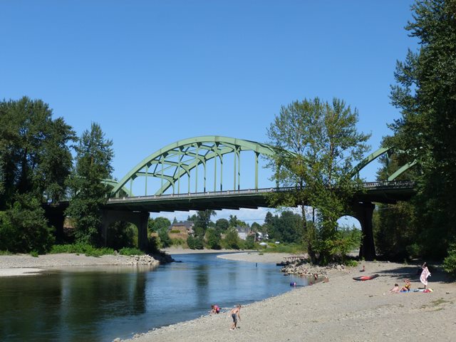
This bridge is an impressive steel arch bridge. It retains original decorative concrete railings and decorative pylons at the ends of the bridge. Although trees today somewhat obscure them, a journey underneath the bridge will reveal impressive curved t-beam approach spans supported by ornate concrete piers. The bridge was designed by the Oregon State Highway Commission under the direction of noted engineer Conde McCullough, who placed emphasis on designing bridges with substantial aesthetic details.
Information and Findings From Oregon's Historic Bridge InventoryDescription Three steel tied through arch spans with a total length of 720-ft Builders Lindstrom and Feigenson Significance This bridge won an Award for Merit in 1933 from the American Institute of Steel Construction and is the largest crossing built as part of the major realignment of the Pacific Highway between Oregon City and Portland. The design includes decorative entry pylons. The bridge was dedicated to Dr. John McLoughlin, a leading figure in the development of the modern Pacific Northwest. Bridge Considered Historic By Survey: Yes |
![]()
![]()
![]()
Coordinates (Latitude, Longitude):
Search For Additional Bridge Listings:
Bridgehunter.com: View listed bridges within 0.5 miles (0.8 kilometers) of this bridge.
Bridgehunter.com: View listed bridges within 10 miles (16 kilometers) of this bridge.
Additional Maps:
Google Streetview (If Available)
GeoHack (Additional Links and Coordinates)
Apple Maps (Via DuckDuckGo Search)
Apple Maps (Apple devices only)
Android: Open Location In Your Map or GPS App
Flickr Gallery (Find Nearby Photos)
Wikimedia Commons (Find Nearby Photos)
Directions Via Sygic For Android
Directions Via Sygic For iOS and Android Dolphin Browser
USGS National Map (United States Only)
Historical USGS Topo Maps (United States Only)
Historic Aerials (United States Only)
CalTopo Maps (United States Only)

© Copyright 2003-2026, HistoricBridges.org. All Rights Reserved. Disclaimer: HistoricBridges.org is a volunteer group of private citizens. HistoricBridges.org is NOT a government agency, does not represent or work with any governmental agencies, nor is it in any way associated with any government agency or any non-profit organization. While we strive for accuracy in our factual content, HistoricBridges.org offers no guarantee of accuracy. Information is provided "as is" without warranty of any kind, either expressed or implied. Information could include technical inaccuracies or errors of omission. Opinions and commentary are the opinions of the respective HistoricBridges.org member who made them and do not necessarily represent the views of anyone else, including any outside photographers whose images may appear on the page in which the commentary appears. HistoricBridges.org does not bear any responsibility for any consequences resulting from the use of this or any other HistoricBridges.org information. Owners and users of bridges have the responsibility of correctly following all applicable laws, rules, and regulations, regardless of any HistoricBridges.org information.
![]()