We Recommend:
Bach Steel - Experts at historic truss bridge restoration.
BridgeHunter.com Phase 1 is released to the public! - Visit Now
10th Street Bridge

Primary Photographer(s): Nathan Holth
Bridge Documented: July 15, 2003, August 15, 2006, July 18, 2013, November 17, 2019, and November 19, 2020
Port Huron: St. Clair County, Michigan: United States
Metal Variable Depth Deck Girder, Movable: Double Leaf Bascule (Rolling Lift) and Approach Spans: Metal Stringer (Multi-Beam), Fixed
1958 By Builder/Contractor: Walter Toebe Company and Engineer/Design: Hazelet and Erdal of Chicago, Illinois
2002
190.0 Feet (57.9 Meters)
375.0 Feet (114.3 Meters)
44 Feet (13.41 Meters)
1 Main Span(s) and 2 Approach Span(s)
Not Applicable

View Information About HSR Ratings
Bridge Documentation
View Archived National Bridge Inventory Report - Has Additional Details and Evaluation
View Historical Articles About This Bridge
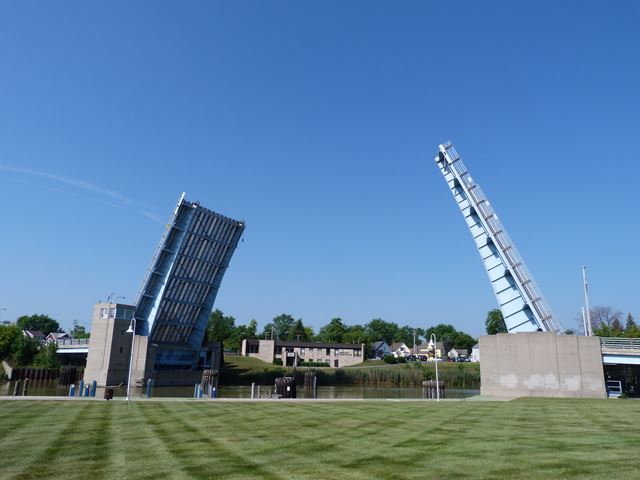
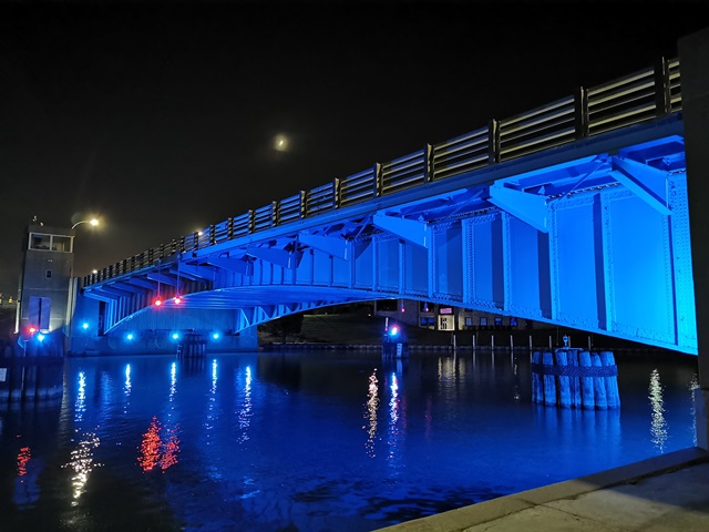
This is Port Huron's largest and least-opened highway bascule bridge. It is larger because it crosses the river at an angle, although the structure's bascule span is not skewed. All three of Port Huron's bascule bridges operate many times a day in the summer, but 10th Street opens less because it is the furthest inland from the St. Clair River. Boats that dock between 10th Street and St. Clair River don't need to pass under this bridge.
This bridge was built during 1956-1958 and it replaced a gorgeous pin connected swing bridge that featured ornate railings and deck plate girder approaches.
The renovations made to this bridge in 2002 upgraded the equipment. You can see some of this from the northeast quadrant around the bridge, where you can peek through a fence and see some of the mechanics of the tail lock. The renovations should not be called a restoration however, since the original historic railings were removed as part of the work. The end result was a severe loss in the beauty and historic integrity of the structure. The bridge was originally designed with Michigan State Highway Department's attractive type R4 railing. During rehabilitation, sidewalk cantilevers were also removed and replaced. The bascule girders and bridge tender house retain original design however. The previous bridge at this location was a swing bridge. The July 31, 1897 issue of The Engineering Record stated that a contract for the 10th Street Bridge was awarded to Groton Bridge Company of Groton, New York for $19,300, which may refer to this bridge.
This bridge is tagged with the following special condition(s): Unorganized Photos
![]()
Photo Galleries and Videos: 10th Street Bridge
Bridge Photo-Documentation
Original / Full Size PhotosA collection of overview and detail photos. This gallery offers photos in the highest available resolution and file size in a touch-friendly popup viewer.
Alternatively, Browse Without Using Viewer
![]()
Bridge Photo-Documentation
Mobile Optimized PhotosA collection of overview and detail photos. This gallery features data-friendly, fast-loading photos in a touch-friendly popup viewer.
Alternatively, Browse Without Using Viewer
![]()
Bridge Being Raised
Full Motion VideoStreaming video of the bridge. Also includes a higher quality downloadable video for greater clarity or offline viewing.
![]()
Bridge Being Lowered
Full Motion VideoStreaming video of the bridge. Also includes a higher quality downloadable video for greater clarity or offline viewing.
![]()
Bridge Being Raised, Wide Angle View
Full Motion VideoNote: The downloadable high quality version of this video (available on the video page) is well worth the download since it offers excellent 1080 HD detail and is vastly more impressive than the compressed streaming video. Streaming video of the bridge. Also includes a higher quality downloadable video for greater clarity or offline viewing.
![]()
Additional Unorganized Photos
Original / Full Size PhotosA supplemental collection of photos that are from additional visit(s) to the bridge and have not been organized or captioned. This gallery offers photos in the highest available resolution and file size in a touch-friendly popup viewer.
Alternatively, Browse Without Using Viewer
![]()
Additional Unorganized Photos
Mobile Optimized PhotosA supplemental collection of photos that are from additional visit(s) to the bridge and have not been organized or captioned. This gallery features data-friendly, fast-loading photos in a touch-friendly popup viewer.
Alternatively, Browse Without Using Viewer
![]()
Maps and Links: 10th Street Bridge
Coordinates (Latitude, Longitude):
Search For Additional Bridge Listings:
Bridgehunter.com: View listed bridges within 0.5 miles (0.8 kilometers) of this bridge.
Bridgehunter.com: View listed bridges within 10 miles (16 kilometers) of this bridge.
Additional Maps:
Google Streetview (If Available)
GeoHack (Additional Links and Coordinates)
Apple Maps (Via DuckDuckGo Search)
Apple Maps (Apple devices only)
Android: Open Location In Your Map or GPS App
Flickr Gallery (Find Nearby Photos)
Wikimedia Commons (Find Nearby Photos)
Directions Via Sygic For Android
Directions Via Sygic For iOS and Android Dolphin Browser
USGS National Map (United States Only)
Historical USGS Topo Maps (United States Only)
Historic Aerials (United States Only)
CalTopo Maps (United States Only)


