We Recommend:
Bach Steel - Experts at historic truss bridge restoration.
BridgeHunter.com Phase 1 is released to the public! - Visit Now
Military Street Railroad Overpass

Primary Photographer(s): Nathan Holth
Bridge Documented: April 21, 2003 - April 24, 2010
Port Huron: St. Clair County, Michigan: United States
1949
70.0 Feet (21.3 Meters)
70.0 Feet (21.3 Meters)
44 Feet (13.41 Meters)
1 Main Span(s)
77177032000R010

View Information About HSR Ratings
Bridge Documentation
This bridge no longer exists!
View Archived National Bridge Inventory Report - Has Additional Details and Evaluation
This bridge has been demolished and replaced!
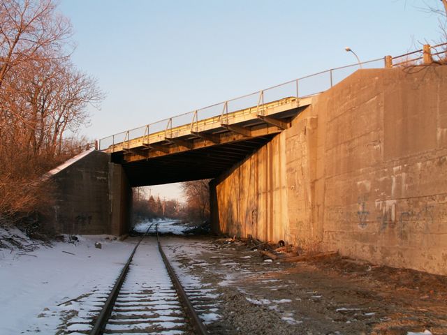
For over a century this utilitarian structure has served a major road in the city of Port Huron. With a construction date of 1906, the structure is the oldest bridge in Port Huron. The through plate girder bridge has an extremely heavy skew. Unlike some other states like Pennsylvania and New York, Michigan does not have many plate girder highway bridges, and thus this is actually a rare structure for Michigan.
Up until the 21st Century, this bridge allowed trains to pass under it into a rail yard that originally included a ferry to carry trains over the St. Clair River to Canada. This ended long ago, and more recently the railroad line dead-ended at Black River at the yard, until the area's philanthropist organization, Acheson Ventures, bought the CSX rail yard from CSX. This rendered the bridge pointless. Worse, the bridge was in poor shape, and MDOT had as of 2010 added structural supports to make the bridge function like a multi-span bridge. By 2013, the bridge had been demolished and replaced with a hideous looking concrete box culvert that allows pedestrians (who are not claustrophobic) to utilize the rail-trail that now follows the former railroad line.
This bridge has had its historic and aesthetic integrity compromised by a redone sidewalk. This bridge once had very beautiful latticed railings for the sidewalk. When the sidewalk on the bridge was redone, the railings of the main span were replaced - with simple and ugly cyclone fencing. The approaches to the bridge still retain original pole railings, however. Sadly, HistoricBridges.org photos date to after the loss of the lattice railing.
Michigan State Highway Department plaques remain on the bridge as well. These plaques do not reference the original construction of the bridge, but instead some major rehabilitation project that occurred in 1949. No plaque is present on the bridge in regards to the original 1906 erection of this bridge.
![]()
Photo Galleries and Videos: Military Street Railroad Overpass
Bridge Photo-Documentation
Original / Full Size PhotosA collection of overview and detail photos. This gallery offers photos in the highest available resolution and file size in a touch-friendly popup viewer.
Alternatively, Browse Without Using Viewer
![]()
Bridge Photo-Documentation
Mobile Optimized PhotosA collection of overview and detail photos. This gallery features data-friendly, fast-loading photos in a touch-friendly popup viewer.
Alternatively, Browse Without Using Viewer
![]()
Maps and Links: Military Street Railroad Overpass
This historic bridge has been demolished. This map is shown for reference purposes only.
Coordinates (Latitude, Longitude):
Search For Additional Bridge Listings:
Bridgehunter.com: View listed bridges within 0.5 miles (0.8 kilometers) of this bridge.
Bridgehunter.com: View listed bridges within 10 miles (16 kilometers) of this bridge.
Additional Maps:
Google Streetview (If Available)
GeoHack (Additional Links and Coordinates)
Apple Maps (Via DuckDuckGo Search)
Apple Maps (Apple devices only)
Android: Open Location In Your Map or GPS App
Flickr Gallery (Find Nearby Photos)
Wikimedia Commons (Find Nearby Photos)
Directions Via Sygic For Android
Directions Via Sygic For iOS and Android Dolphin Browser
USGS National Map (United States Only)
Historical USGS Topo Maps (United States Only)
Historic Aerials (United States Only)
CalTopo Maps (United States Only)

