We Recommend:
Bach Steel - Experts at historic truss bridge restoration.
BridgeHunter.com Phase 1 is released to the public! - Visit Now
Franklin Street Bridge

Primary Photographer(s): Nathan Holth
Bridge Documented: July 2004 and August 2010
Titusville: Crawford County, Pennsylvania: United States
1939 By Builder/Contractor: Tonawanda Engineering Corporation and Engineer/Design: Karl A. Miller
1981
180.0 Feet (54.9 Meters)
185.0 Feet (56.4 Meters)
30.5 Feet (9.3 Meters)
1 Main Span(s)
200008001019710

View Information About HSR Ratings
Bridge Documentation
View Archived National Bridge Inventory Report - Has Additional Details and Evaluation
View Historic American Engineering Record (HAER) Documentation For This Bridge
HAER Data Pages, PDF
About This Bridge
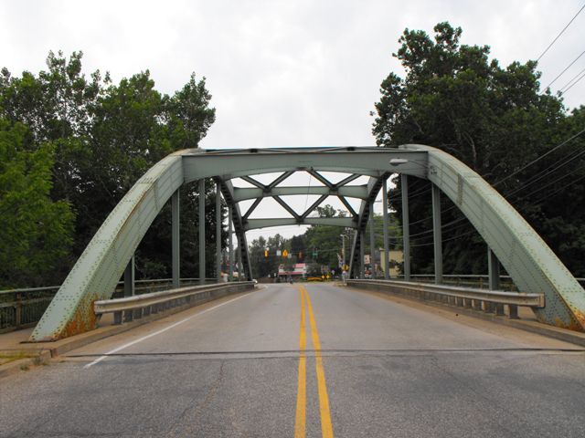
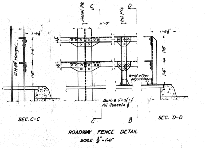
This bridge may at first glance seem rather simple and plain after visiting the wondrous truss bridges that remain in Crawford County, but this is nevertheless an interesting and beautiful bridge with historic significance as a rare example of its steel tied through arch type and also significant as the work of a local (county) engineer. There is no v-lacing on this bridge, but the arch is all riveted together, which allows one to quickly see that this is indeed a historic bridge. The bridge must have looked a bit futuristic when it was built, since it is relatively simple looking. According to a plaque on the bridge, this bridge was built in 1939. The sway bracing on this bridge has a bit of an arch-like curve to it which adds some additional aesthetic value to the bridge. Original guardrails, which are a style commonly seen on Pennsylvania bridges remain on the pedestrian sidewalks of the bridge. Modern metal guardrails keep the cars on the road. The design of the original railings, now removed, can be seen on the original plans. A clipping is shown on this page.
The bridge replaced a single span eleven panel Camelback through truss, located on the same location, although the replacement bridge straightened the alignment a little bit. Select portions of the original stone abutments were retained or reused for the construction of the new bridge's abutments.

Karl A. Miller - Inspiration For Today
The bridge reveals a rather unusual and fascinating history. The bridge was entirely the design of a county engineer, Karl A. Miller. This in itself was not overly unusual, although in the late 1930s, one might have expected a county engineer to simply use any of the available state standard plans that the state highway department would likely have had available. Instead, Miller came up with his own unique steel tied arch design. Apparently, the design caught the attention of Oil City in neighboring Venango County who ended up building a nearly identical structure based on the same design, which Karl Miller apparently assisted with. As such, these two bridges are an unusual example of a county-designed bridge appearing in two different counties.
Karl Miller was a rather interesting individual, and perhaps ahead of his time. Historic American Engineering Record research into Miller shows that he was an engineer who placed great value on repairing and maintaining bridges rather than replacing them. It would seem that decades ago, this county engineer was able to grasp what today's engineers and DOTs often seem incapable of understanding, which is that maintaining and repairing bridges is more fiscally responsible and also promotes greater bridge safety.
Another interesting thing found about Karl Miller was that he may have shared something with historic bridge enthusiasts today, which is an appreciation for the shear variety of bridge designs found in Crawford County. Many of his photographs feature various bridges in the county. In 1939, the bridges that made Crawford County special at the turn of the 21st Century were standing back then as well. What is interesting is that Karl Miller did not take these bridges for granted and actually may have seen them for the treasures they are.
A Future For The Franklin Street Bridge
In 2010 bidding was let for the rehabilitation of this beautiful historic bridge by PennDOT. The rehabilitation of this historic bridge represents not only a commitment to fiscal responsibility and sustainability but also a commitment to the preservation of this historic bridge. The rehabilitation of this bridge is a win-win scenario, for both preservationists as well as the general public wishing only for a functional crossing. The rehabilitation of the bridge appears to be a well-designed rehabilitation that respects the historic integrity of the bridge. For example, the original sidewalk railings will not be replaced, and will instead be removed, galvanized, and reinstalled on the bridge. The main features of the scope of work include deck replacement, replacement of abutment backwalls, replacement of sidewalk fascia channels with galvanized fascia channels, and spot painting of the structure. The existing modern metal Armco style guardrail will be replaced with a concrete barrier. Some post tensioning bars will also be installed on the bridge.
Information and Findings From Pennsylvania's Historic Bridge InventoryDiscussion of Bridge The 1939, single span, 185'-long, tied arch bridge was designed and built by the Tonawanda Engineering Corporation. It is supported on ashlar abutments. The ribs are built-up riveted box sections and the ties are pin connected eyebars. The bridge is historically and technologically significant as an example of a rare type and design in Pennsylvania. Discussion of Surrounding Area The bridge carries a 2 lane highway and sidewalks over a stream in Titusville borough, south of the Titusville Historic District, which encompasses the central business district 4 blocks to the north. To the north is a neighborhood dominated by undistinguished, early 20th century vernacular houses and scattered commercial buildings, also undistinguished. There is also a late 20th century fast food restaurant at the northeast quadrant. To the south is a residential area of predominantly post-WW II houses. Bridge Considered Historic By Survey: Yes |
![]()
Photo Galleries and Videos: Franklin Street Bridge
Bridge Photo-Documentation
Original / Full Size PhotosA collection of overview and detail photos. This gallery offers photos in the highest available resolution and file size in a touch-friendly popup viewer.
Alternatively, Browse Without Using Viewer
![]()
Bridge Photo-Documentation
Mobile Optimized PhotosA collection of overview and detail photos. This gallery features data-friendly, fast-loading photos in a touch-friendly popup viewer.
Alternatively, Browse Without Using Viewer
![]()
Maps and Links: Franklin Street Bridge
Coordinates (Latitude, Longitude):
Search For Additional Bridge Listings:
Bridgehunter.com: View listed bridges within 0.5 miles (0.8 kilometers) of this bridge.
Bridgehunter.com: View listed bridges within 10 miles (16 kilometers) of this bridge.
Additional Maps:
Google Streetview (If Available)
GeoHack (Additional Links and Coordinates)
Apple Maps (Via DuckDuckGo Search)
Apple Maps (Apple devices only)
Android: Open Location In Your Map or GPS App
Flickr Gallery (Find Nearby Photos)
Wikimedia Commons (Find Nearby Photos)
Directions Via Sygic For Android
Directions Via Sygic For iOS and Android Dolphin Browser
USGS National Map (United States Only)
Historical USGS Topo Maps (United States Only)
Historic Aerials (United States Only)
CalTopo Maps (United States Only)


