

View Information About HSR Ratings

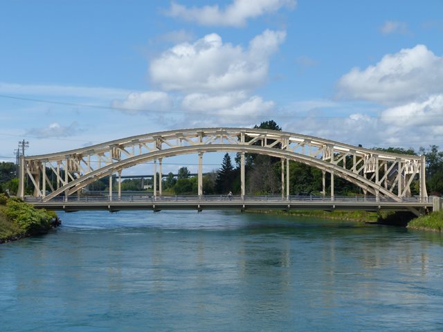
Sault. Ste. Marie, Michigan has an unusually high number of unusual steel bridges. With its massive members, but unusually short span length for its type, this steel arch bridge on Ashmun Street, remains in excellent condition, maintained at its original Power Canal location. Power Canal is aptly named as its water flow is used for generating power. As a result of the unusual power-generating and high velocity nature of the canal, none of the bridges over the canal were built with supports in the water. This resulted in some bridge designs that ended up being unusual, like this bridge for example. The Asumun Street Bridge is a single span steel through arch bridge. Steel arch bridges are a fairly uncommon structure type, and are downright rare in Michigan. Nationwide, most steel through arch bridges tend to be used for long span crossings, often high level for navigational use. The Ashmun Street Bridge's span length of 257 feet, too long for the steel stringer bridges that Michigan commonly built during this period, is in contrast short compared to other steel through arch bridges in the country.
The bridge according to the original plans was designed to function as a three hinge arch for dead loads and a two hinge arch for live loads.
With its unusual, and graceful through arch design, this bridge is extremely pleasing on an aesthetic level. Perhaps this bridge type was selected over other common bridge types that might be expected to be seen in a span length like this, like a steel truss bridge for aesthetic reasons. It is also possible that the structure type was selected because of ease of construction over the Power Canal. It is possible that this arch bridge was constructed using the cantilever method, or by using backstays. Both solutions would have prevented the need for falsework in the canal. In contrast, constructing a metal truss bridge over the canal might have been harder to do without putting falsework in the river during construction.
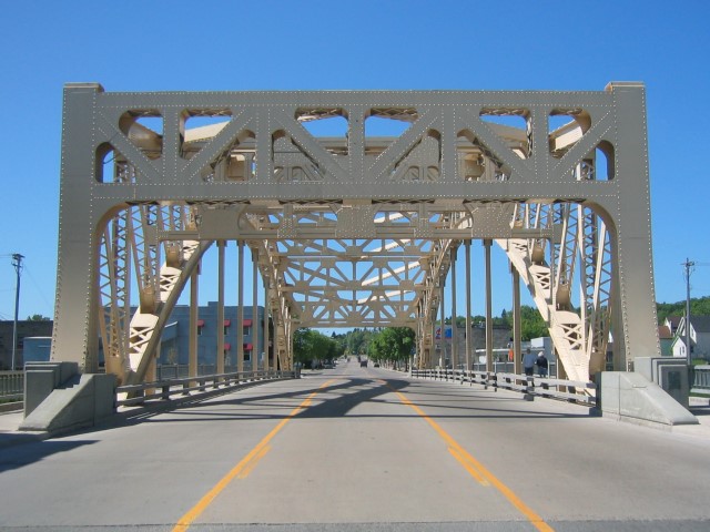
A plaque is present on the bridge, which identifies that the bridge was built in 1935, by Fry and Kain Inc, and Robert Hudson. The bridge was built jointly by the state of Michigan and the federal government. The plaque also mentions that the bridge was built with the cooperation of the Michigan Northern Power Company, most likely because the canal was the property of the power company. Between the two arch lines, it carries two lanes and a left turn lane. Cantilevered sidewalks are present on both sides outside the arches. Guardrails for the road (standard MDOT two tube railing design) appear have been added, as they are of a modern style. There originally were no guardrails for cars on the bridge. The only railing on the bridge originally would have been on the sidewalks. The pedestrian railings on the bridge are an attractive standard Michigan design (called the R4 railing), often seen on bridges from the 1930s through the early 1960s.
MDOT has taken good care of this bridge, and the bridge retains a quality paint job. In 2005, Luke Gordon briefly revisited this bridge, and found that it was still in excellent condition. However, a town announcement sign had been placed on the portal. While the bridge is a beautiful gateway, and might seem an appropriate place for a sign with messages about Sault Ste. Marie, it really detracts from the beauty of the structure itself, which deserves to stand alone, unobstructed by a distracting sign.
Information and Findings From Michigan Historic Bridge InventoryNarrative Description The method used in constructing this bridge was innovative, in that the old bridge being replaced was left standing and used as falsework to support the new structure, before being removed. This is one of only three steel arch bridges in Michigan and is a massive structure, measuring 42 feet wide and 257 feet in length. The Michigan State Highway Department designed the structure and the builders were Fry & Kain, Inc. and Robert Hudson. |
![]()
![]()
![]()
![]()
![]()
Coordinates (Latitude, Longitude):
Search For Additional Bridge Listings:
Bridgehunter.com: View listed bridges within 0.5 miles (0.8 kilometers) of this bridge.
Bridgehunter.com: View listed bridges within 10 miles (16 kilometers) of this bridge.
Additional Maps:
Google Streetview (If Available)
GeoHack (Additional Links and Coordinates)
Apple Maps (Via DuckDuckGo Search)
Apple Maps (Apple devices only)
Android: Open Location In Your Map or GPS App
Flickr Gallery (Find Nearby Photos)
Wikimedia Commons (Find Nearby Photos)
Directions Via Sygic For Android
Directions Via Sygic For iOS and Android Dolphin Browser
USGS National Map (United States Only)
Historical USGS Topo Maps (United States Only)
Historic Aerials (United States Only)
CalTopo Maps (United States Only)

© Copyright 2003-2025, HistoricBridges.org. All Rights Reserved. Disclaimer: HistoricBridges.org is a volunteer group of private citizens. HistoricBridges.org is NOT a government agency, does not represent or work with any governmental agencies, nor is it in any way associated with any government agency or any non-profit organization. While we strive for accuracy in our factual content, HistoricBridges.org offers no guarantee of accuracy. Information is provided "as is" without warranty of any kind, either expressed or implied. Information could include technical inaccuracies or errors of omission. Opinions and commentary are the opinions of the respective HistoricBridges.org member who made them and do not necessarily represent the views of anyone else, including any outside photographers whose images may appear on the page in which the commentary appears. HistoricBridges.org does not bear any responsibility for any consequences resulting from the use of this or any other HistoricBridges.org information. Owners and users of bridges have the responsibility of correctly following all applicable laws, rules, and regulations, regardless of any HistoricBridges.org information.
![]()