

View Information About HSR Ratings
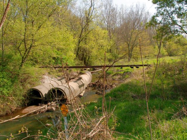
Just off of the BL-94 leading out of Kalamazoo to I-94, hundreds of people pass by the most remarkable bridge design ever seen. This breathtaking structure eliminates, piers, abutments, and even beams, and represents the most efficient of bridge designs. With no piers and abutments, the rails themselves form the bridge structure, relying only on the rails leading up to the bridge for support! Wooden railroad ties provide stability to the structure. The engineering design of this bridge combines the laws of the cantilever bridge, the suspension bridge, and the steel stringer bridge all into one convenient and economical design. The rails cantilever out from the rails leading up to the structure. Then, acting as parallel beams that function as a stringer structure. Slight flex in the connections between each rail section provides a slight suspension design as well.
While other railroad companies were contracting companies to built expensive and bulky plate girders and truss bridges, this unknown company learned that the very rails that the train travels upon were more than enough to compose a small bridge. One can only guess when this bridge might have been built. It has not had the opportunity to demonstrate its ingenious design for decades, to be sure, as there is extensive growth on the tracks leading up to the bridge.
OK, folks, this isn't for real! You found it, buried amongst thousands bridges on this website: the official gag bridge! This is really just a culvert that got the dirt above the culverts washed away in a flood, which left the abandoned railroad tracks hanging in midair! This "structure" was spotted while leaving Kalamazoo one day, and we thought it would be fun to add it to the website as a joke. In light of all the tragic historic bridge demolitions going on, it is a nice opportunity to sit back and laugh for a bit!
![]()
![]()
Coordinates (Latitude, Longitude):
Search For Additional Bridge Listings:
Bridgehunter.com: View listed bridges within 0.5 miles (0.8 kilometers) of this bridge.
Bridgehunter.com: View listed bridges within 10 miles (16 kilometers) of this bridge.
Additional Maps:
Google Streetview (If Available)
GeoHack (Additional Links and Coordinates)
Apple Maps (Via DuckDuckGo Search)
Apple Maps (Apple devices only)
Android: Open Location In Your Map or GPS App
Flickr Gallery (Find Nearby Photos)
Wikimedia Commons (Find Nearby Photos)
Directions Via Sygic For Android
Directions Via Sygic For iOS and Android Dolphin Browser
USGS National Map (United States Only)
Historical USGS Topo Maps (United States Only)
Historic Aerials (United States Only)
CalTopo Maps (United States Only)

© Copyright 2003-2025, HistoricBridges.org. All Rights Reserved. Disclaimer: HistoricBridges.org is a volunteer group of private citizens. HistoricBridges.org is NOT a government agency, does not represent or work with any governmental agencies, nor is it in any way associated with any government agency or any non-profit organization. While we strive for accuracy in our factual content, HistoricBridges.org offers no guarantee of accuracy. Information is provided "as is" without warranty of any kind, either expressed or implied. Information could include technical inaccuracies or errors of omission. Opinions and commentary are the opinions of the respective HistoricBridges.org member who made them and do not necessarily represent the views of anyone else, including any outside photographers whose images may appear on the page in which the commentary appears. HistoricBridges.org does not bear any responsibility for any consequences resulting from the use of this or any other HistoricBridges.org information. Owners and users of bridges have the responsibility of correctly following all applicable laws, rules, and regulations, regardless of any HistoricBridges.org information.
![]()