

View Information About HSR Ratings
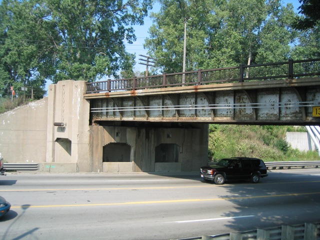
This is a historically intact example of a deck plate girder railroad overpass. A limited number of similar overpasses exists elsewhere on Michigan, all apparently designed by the Michigan State Highway Department. The exact design of each overpass can vary however including both structural and architectural details. This overpass is distinguished by its well decorated substructure which includes an unusual design where a pier and abutment are combined to provide a span over the sidewalks. This bridge is missing its Michigan State Highway Department plaques. Much of the structure has rusted, but all the original elements appeared to remain in 2003, including the guardrails which were built to the Type R4 railing design that Michigan State Highway Department used. Sometime between 2003 and 2010 someone (probably the railroad) stupidly decided to remove the original railings and put ugly lightweight railings on the bridge in its place. This alteration had a significantly detrimental effect on the aesthetic quality of the overpass. The new railings are less substantial than the original railings, so it is not even clear what was gained from this alteration. The historic railings were rusted, but if the railroad had wished them to be replaced, MDOT likely could have provided R4 railing panels to replace them. MDOT maintains a stockpile of R4 railings salvaged from replacement projects that are available for preservation work.
This bridge is similar to the M-53 Imlay City Railroad Bridge.
![]()
![]()
![]()
Coordinates (Latitude, Longitude):
Search For Additional Bridge Listings:
Bridgehunter.com: View listed bridges within 0.5 miles (0.8 kilometers) of this bridge.
Bridgehunter.com: View listed bridges within 10 miles (16 kilometers) of this bridge.
Additional Maps:
Google Streetview (If Available)
GeoHack (Additional Links and Coordinates)
Apple Maps (Via DuckDuckGo Search)
Apple Maps (Apple devices only)
Android: Open Location In Your Map or GPS App
Flickr Gallery (Find Nearby Photos)
Wikimedia Commons (Find Nearby Photos)
Directions Via Sygic For Android
Directions Via Sygic For iOS and Android Dolphin Browser
USGS National Map (United States Only)
Historical USGS Topo Maps (United States Only)
Historic Aerials (United States Only)
CalTopo Maps (United States Only)

© Copyright 2003-2025, HistoricBridges.org. All Rights Reserved. Disclaimer: HistoricBridges.org is a volunteer group of private citizens. HistoricBridges.org is NOT a government agency, does not represent or work with any governmental agencies, nor is it in any way associated with any government agency or any non-profit organization. While we strive for accuracy in our factual content, HistoricBridges.org offers no guarantee of accuracy. Information is provided "as is" without warranty of any kind, either expressed or implied. Information could include technical inaccuracies or errors of omission. Opinions and commentary are the opinions of the respective HistoricBridges.org member who made them and do not necessarily represent the views of anyone else, including any outside photographers whose images may appear on the page in which the commentary appears. HistoricBridges.org does not bear any responsibility for any consequences resulting from the use of this or any other HistoricBridges.org information. Owners and users of bridges have the responsibility of correctly following all applicable laws, rules, and regulations, regardless of any HistoricBridges.org information.
![]()