We Recommend:
Bach Steel - Experts at historic truss bridge restoration.
BridgeHunter.com Phase 1 is released to the public! - Visit Now
42nd Street Bridge

Primary Photographer(s): Nathan Holth and Rick McOmber
Bridge Documented: May 31, 2010
Philadelphia: Philadelphia County, Pennsylvania: United States
Metal Solid Ribbed Through Arch, Fixed and Approach Spans: Concrete Continuous Deck Girder, Fixed
1909 By Builder/Contractor: Owego Bridge Company of Owego, New York and Engineer/Design: Philadelphia Department of Public Works
2006
262.0 Feet (79.9 Meters)
308.0 Feet (93.9 Meters)
30.8 Feet (9.39 Meters)
1 Main Span(s) and 2 Approach Span(s)
67730102700125

View Information About HSR Ratings
Bridge Documentation
View Archived National Bridge Inventory Report - Has Additional Details and Evaluation
View Historical Article About This Bridge
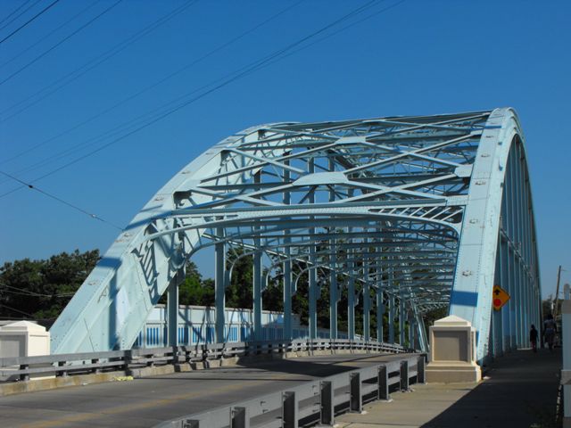
This bridge is a rare example of a historic metal through arch bridge. Metal through arch bridges are an uncommon structure type. This bridge is significant on a state level as the oldest steel through arch in Pennsylvania. Additional significance for the bridge arises from the fact that the bridge is a contributing structure to the historic Pennsylvania Railroad main line, which the bridge crosses. The bridge is composed of a riveted built-up solid arch rib with rolled i-beam spandrel columns. The bridge has overhead sway bracing that is composed of built-up beams, with the bottom section having a decorative arched design.
This bridge is an excellent example of a compromise rehabilitation. In 2006, the bridge received an extensive rehabilitation. HistoricBridges.org calls this rehabilitation a compromise because a significant amount of original bridge material was replaced, reducing the historic integrity of the bridge, however doing so had the result of producing a final product that in terms of structural condition is like-new and can easily be expected to have a service life that will be equal to or far greater than any modern bridge would have offered. Indeed, two years after the rehabilitation, this bridge received a 9/9 (Excellent) rating, the highest possible ratings in the National Bridge Inventory, for all three bridge elements: deck, superstructure and substructure. Such high ratings for a historic bridge, even one that has been rehabilitated, are nearly unheard of. As mentioned it appears that large quantities of original bridge material have been replaced. Large numbers of rivets on the bridge were replaced with bolts. It appears that the sway bracing was all replaced as well, but it appears to have been replaced in-kind so that the design and appearance remains the same. The spandrel columns were also strengthened during rehabilitation. In conclusion, this bridge is an excellent example of how a historic bridge can be rehabilitated to the point where it offers structural integrity equal to that of a new replacement bridge. The city-owned bridge serves as a counter-example to the normal position and opinion of the Pennsylvania Department of Transportation (PennDOT) that a rehabilitated historic metal bridge (such as a truss or arch bridge) will only offer an additional 25 years of service. The 42nd Street Bridge, rehabilitated to like-new condition can now easily provide an additional 75-100 years of service, with routine maintenance and repair.
Information and Findings From Pennsylvania's Historic Bridge InventoryDiscussion of Bridge The 250' long bridge is composed of a hingeless steel thru arch with a concrete jack arch deck. The solid rib, built-up arches taper from 9 1/2' deep at the skewbacks to 4 1/2' at the crown. The bridge was designed by the City of Philadelphia Dept. of Public Works, and it is technologically significant as the earliest steel thru arch bridge in the state. Additionally, it crosses the historic PA RR main line, and it was built as part of the improvements of the historic line. The bridge is historically significant in association with the PRR main line. Discussion of Surrounding Area The bridge carries a 2 lane street with sidewalks over 4 electrified tracks and 2 non-electrified tracks of the former Pennsylvania Railroad's main line that PHMC has determined eligible (1993), but none of the bridges were evaluated as part of their determination. The route is now operated by Amtrak. The bridge is south of and not in the Parkside Historic District. The large bridge is the dominant landscape feature in the area. Bridge Considered Historic By Survey: Yes |
![]()
Photo Galleries and Videos: 42nd Street Bridge
Bridge Photo-Documentation
Original / Full Size PhotosA collection of overview and detail photos. This gallery offers photos in the highest available resolution and file size in a touch-friendly popup viewer.
Alternatively, Browse Without Using Viewer
![]()
Bridge Photo-Documentation
Mobile Optimized PhotosA collection of overview and detail photos. This gallery features data-friendly, fast-loading photos in a touch-friendly popup viewer.
Alternatively, Browse Without Using Viewer
![]()
Southbound Crossing of the Bridge
Full Motion VideoStreaming video of the bridge. Also includes a higher quality downloadable video for greater clarity or offline viewing.
![]()
Northbound Crossing of the Bridge
Full Motion VideoStreaming video of the bridge. Also includes a higher quality downloadable video for greater clarity or offline viewing.
![]()
Maps and Links: 42nd Street Bridge
Coordinates (Latitude, Longitude):
Search For Additional Bridge Listings:
Bridgehunter.com: View listed bridges within 0.5 miles (0.8 kilometers) of this bridge.
Bridgehunter.com: View listed bridges within 10 miles (16 kilometers) of this bridge.
Additional Maps:
Google Streetview (If Available)
GeoHack (Additional Links and Coordinates)
Apple Maps (Via DuckDuckGo Search)
Apple Maps (Apple devices only)
Android: Open Location In Your Map or GPS App
Flickr Gallery (Find Nearby Photos)
Wikimedia Commons (Find Nearby Photos)
Directions Via Sygic For Android
Directions Via Sygic For iOS and Android Dolphin Browser
USGS National Map (United States Only)
Historical USGS Topo Maps (United States Only)
Historic Aerials (United States Only)
CalTopo Maps (United States Only)


