We Recommend:
Bach Steel - Experts at historic truss bridge restoration.
BridgeHunter.com Phase 1 is released to the public! - Visit Now
Bairdstown Bridge
Old Blairsville Bridge

Primary Photographer(s): Nathan Holth and Rick McOmber
Bridge Documented: August 1, 2007
Blairsville: Indiana County, Pennsylvania and Westmoreland County, Pennsylvania: United States
Metal 20 Panel Rivet-Connected Baltimore Through Truss, Fixed and Approach Spans: Metal Through Girder, Fixed
1935 By Builder/Contractor: Freeland McHale and PA and Engineer/Design: Pennsylvania State Highway Department
1993
290.0 Feet (88.4 Meters)
358.0 Feet (109.1 Meters)
30.8 Feet (9.39 Meters)
1 Main Span(s) and 1 Approach Span(s)
322002001000000

View Information About HSR Ratings
Bridge Documentation
View Archived National Bridge Inventory Report - Has Additional Details and Evaluation
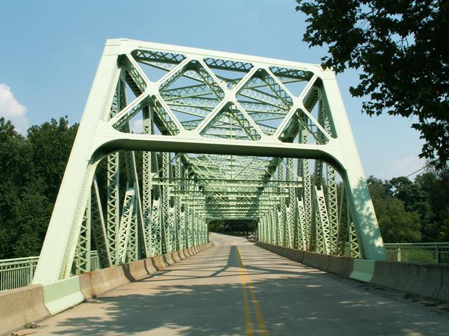
At first glance this appears to be an attractive standard plan 1930s truss in Pennsylvania. For the most part it is, however unlike most other bridges from this period in the state which utilize the Pratt or Parker truss configurations, this bridge is a Baltimore. This gives this bridge more significance than other bridges from the period, since it is a variation from the most commonly employed standard plans of the period. Extensive lattice and v-lacing on the built-up beams of this bridge add greatly to the high level of aesthetic value this bridge enjoys.
The bridge includes a 60 foot through girder approach spans. The bridge also has a slight 1.5% grade. The bridge is skewed. There is eighteen feet between the bottom of the portal bracing and the deck.
The bridge sits at a historical crossing, and is the fourth bridge at the site. The first bridge here was built in 1821-1823 and was a 300 foot arch of unknown material, but formed the longest single arch span in the United States when built. It was a toll bridge until 1865. The crossing and the formers bridges were considered noteworthy enough that a large plaque was erected on this bridge when it was built to commemorate the highways and previous bridges. The crossing was originally the Northern Turnpike which was later called the William Penn Highway, which later became US-22, which is today carried on a nearby alignment.
The bridge was fabricated by the Rankin Works of the McClintic-Marshall Company, a Pittsburgh company. The bridge was erected by on-site contractors Freeland McHale and PA. Pennsylvania State Highway Department provided the design engineering and plans for the bridge.
This bridge also enjoys a reduced traffic load, since the new Blairsville Bridge, dating to 1951, passes by to the north of this bridge. A dam that was constructed in the region appears to sometimes cause water to fill in this area which now acts as a reservoir of sorts. In 2010, waters came up to the portal of the bridge (photos are available in the gallery). However, the massive bridge combined with what appeared to be slow flow rate of water meant that little hazard was posed to the bridge, and with a high level modern bridge nearby, traffic had a convenient alternate route. Thus, the preservation of the Old Blairsville Bridge should be considered feasible.
Information and Findings From Pennsylvania's Historic Bridge InventoryDiscussion of Bridge The skewed, 2-span, 358'-long bridge with a 283' long riveted Baltimore thru truss main span and a thru girder approach span is supported on concrete abutments with wingwalls and a concrete pier. All members of the high capacity truss are built up. The panels are subdivided with a substrut and a hanger to pick up the intermediate floor beam. Although a large heavy truss, the bridge has no innovative or distinctive details. It is an example of a technology that is well represented in the western part of the state with its long river crossings. It is reflective of common period technology and is not historically or technologically significant. The plaque states that the first bridge at this crossing was placed in 1823. This is the fourth bridge. Discussion of Surrounding Area The bridge carries a 2 lane street over two active Conrail railroad tracks in Blairsville in a setting that is a mix of parking lots, modern buildings and the 1907 freight depot. The SHPO has determined that Blairsville is not a potential historic district. The railroad line crossed is the former Western Pennsylvania line the Pennsylvania RR improved as a low grade freight route. It is not a significant line. It is operated by Conrail. Bridge Considered Historic By Survey: No |
![]()
Photo Galleries and Videos: Bairdstown Bridge
Bridge Photo-Documentation
A collection of overview and detail photos. This photo gallery contains a combination of Original Size photos and Mobile Optimized photos in a touch-friendly popup viewer.Alternatively, Browse Without Using Viewer
![]()
Maps and Links: Bairdstown Bridge
Coordinates (Latitude, Longitude):
Search For Additional Bridge Listings:
Bridgehunter.com: View listed bridges within 0.5 miles (0.8 kilometers) of this bridge.
Bridgehunter.com: View listed bridges within 10 miles (16 kilometers) of this bridge.
Additional Maps:
Google Streetview (If Available)
GeoHack (Additional Links and Coordinates)
Apple Maps (Via DuckDuckGo Search)
Apple Maps (Apple devices only)
Android: Open Location In Your Map or GPS App
Flickr Gallery (Find Nearby Photos)
Wikimedia Commons (Find Nearby Photos)
Directions Via Sygic For Android
Directions Via Sygic For iOS and Android Dolphin Browser
USGS National Map (United States Only)
Historical USGS Topo Maps (United States Only)
Historic Aerials (United States Only)
CalTopo Maps (United States Only)


