We Recommend:
Bach Steel - Experts at historic truss bridge restoration.
BridgeHunter.com Phase 1 is released to the public! - Visit Now
Bower Bridge
Camp Corbly Road Bridge

Primary Photographer(s): Nathan Holth and Rick McOmber
Bridge Documented: July 14, 2008
Bower: Clearfield County, Pennsylvania: United States
By Builder/Contractor: Unknown
1988
131.0 Feet (39.9 Meters)
132.0 Feet (40.2 Meters)
14.8 Feet (4.51 Meters)
1 Main Span(s)
177217041800050

View Information About HSR Ratings
Bridge Documentation
View Archived National Bridge Inventory Report - Has Additional Details and Evaluation
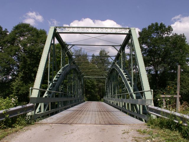
This is a nine panel truss bridge that is traditionally composed. The 1920 construction date that the National bridge Inventory listed for this bridge is incorrect. It does appear to be a later pin-connected truss bridge however, perhaps dating to around 1910. The bridge has been retrofitted and rendered decorative with a steel arch. The steel arch is a way to bypass the truss/superstructure, while continuing to reuse the deck stringers and deck system. They appear to be used both in the name of simple repair projects and also in the name of historic preservation, and tend to show up on older rehab and preservation projects from a decade or two ago and do not show up as often today. As a preservation tool they are one of many compromise preservation alternatives. As preservation tools, arch retrofits are compromise tools because they drastically alter the appearance of the bridge, since as a through arch running through the truss, it is hard for eyes to separate arch from truss visually. However, if deployed properly, they do not require any removal of the original superstructure, so original bridge material is not destroyed, which is a clear benefit versus other invasive preservation solutions such as one where large amounts of steel might be welded to the truss to strengthen it.
Here in Pennsylvania, this retrofit was done simply for economic reasons, not in the name of preservation.
Information and Findings From Pennsylvania's Historic Bridge InventoryDiscussion of Bridge The one-span, 132'-long, steel thru arch bridge was built in 1988 and fitted into the previous ca. 1910 pin-connected Pratt thru truss bridge. The Pratt trusses now merely serve as ornaments that are attached to a modern steel arch superstructure. They have lost their integrity of original design and function. Discussion of Surrounding Area The bridge carries 1 lane of a township road over a stream in a rural area of active farms and woods. Bridge Considered Historic By Survey: No |
This bridge is tagged with the following special condition(s): Trusses Converted To Decorative
![]()
Photo Galleries and Videos: Bower Bridge
Bridge Photo-Documentation
Original / Full Size PhotosA collection of overview and detail photos. This gallery offers photos in the highest available resolution and file size in a touch-friendly popup viewer.
Alternatively, Browse Without Using Viewer
![]()
Bridge Photo-Documentation
Mobile Optimized PhotosA collection of overview and detail photos. This gallery features data-friendly, fast-loading photos in a touch-friendly popup viewer.
Alternatively, Browse Without Using Viewer
![]()
Maps and Links: Bower Bridge
Coordinates (Latitude, Longitude):
Search For Additional Bridge Listings:
Bridgehunter.com: View listed bridges within 0.5 miles (0.8 kilometers) of this bridge.
Bridgehunter.com: View listed bridges within 10 miles (16 kilometers) of this bridge.
Additional Maps:
Google Streetview (If Available)
GeoHack (Additional Links and Coordinates)
Apple Maps (Via DuckDuckGo Search)
Apple Maps (Apple devices only)
Android: Open Location In Your Map or GPS App
Flickr Gallery (Find Nearby Photos)
Wikimedia Commons (Find Nearby Photos)
Directions Via Sygic For Android
Directions Via Sygic For iOS and Android Dolphin Browser
USGS National Map (United States Only)
Historical USGS Topo Maps (United States Only)
Historic Aerials (United States Only)
CalTopo Maps (United States Only)

