

View Information About HSR Ratings
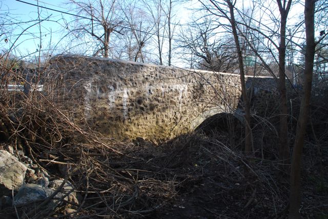
This bridge is one of Chester County's interesting bridges which feature a brick arch ring, but with stone spandrel walls. This example has been altered with a concrete and mortar which have obscured some of the interesting details of this bridge including the bricks. Regardless, the bridge remains far more attractive than any replacement bridge could ever hope to be.
The National Bridge Inventory listed a 1920 construction date for this bridge, which appears to be incorrect. The Historic Bridge Inventory suggests a ca. 1905 date.
Information and Findings From Pennsylvania's Historic Bridge InventoryDiscussion of Bridge The one-span, 21'-long, brick arch bridge has fieldstone spandrel walls and parapets. It is supported on stone abutments. The bridge arch ring, intrados, spandrel walls, and parapets have been pargetted with a thick coat of cementitous material. The original parapet coping has been lost and replaced by a thickly applied layer of cement (ca. 1980). The builder and date of construction are undocumented by available state and county records, but the bridge dates stylistically to ca. 1905 based on the 1901-1908 dates of construction of at least 9 identified brick arch bridges Chester County. There are approximately 25 brick arch highway bridges from about 1864 to 1908 in the state. Other less altered examples in the county and region better represent the technological and historical significance of brick arch bridges within the context of county-built bridge types. Two Chester County-built brick arch bridges have been National Register-listed as a result of the previous historic bridge survey (BMS# 15 4006 0060 1731, built in 1903; and, BMS# 15 4039 0020 0015, built in 1904). Discussion of Surrounding Area The bridge carries 1 lane of a 2 lane road over a stream is in a residential setting of predominately mid to late-20th-century residences. At the bridge's southwest quadrant is a ca. 1960 residence. The other quadrants are open fields. The setting does not have historic district potential. Bridge Considered Historic By Survey: No |
![]()
![]()
![]()
Coordinates (Latitude, Longitude):
Search For Additional Bridge Listings:
Bridgehunter.com: View listed bridges within 0.5 miles (0.8 kilometers) of this bridge.
Bridgehunter.com: View listed bridges within 10 miles (16 kilometers) of this bridge.
Additional Maps:
Google Streetview (If Available)
GeoHack (Additional Links and Coordinates)
Apple Maps (Via DuckDuckGo Search)
Apple Maps (Apple devices only)
Android: Open Location In Your Map or GPS App
Flickr Gallery (Find Nearby Photos)
Wikimedia Commons (Find Nearby Photos)
Directions Via Sygic For Android
Directions Via Sygic For iOS and Android Dolphin Browser
USGS National Map (United States Only)
Historical USGS Topo Maps (United States Only)
Historic Aerials (United States Only)
CalTopo Maps (United States Only)

© Copyright 2003-2026, HistoricBridges.org. All Rights Reserved. Disclaimer: HistoricBridges.org is a volunteer group of private citizens. HistoricBridges.org is NOT a government agency, does not represent or work with any governmental agencies, nor is it in any way associated with any government agency or any non-profit organization. While we strive for accuracy in our factual content, HistoricBridges.org offers no guarantee of accuracy. Information is provided "as is" without warranty of any kind, either expressed or implied. Information could include technical inaccuracies or errors of omission. Opinions and commentary are the opinions of the respective HistoricBridges.org member who made them and do not necessarily represent the views of anyone else, including any outside photographers whose images may appear on the page in which the commentary appears. HistoricBridges.org does not bear any responsibility for any consequences resulting from the use of this or any other HistoricBridges.org information. Owners and users of bridges have the responsibility of correctly following all applicable laws, rules, and regulations, regardless of any HistoricBridges.org information.
![]()