

View Information About HSR Ratings
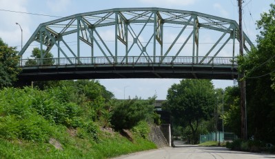
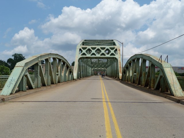
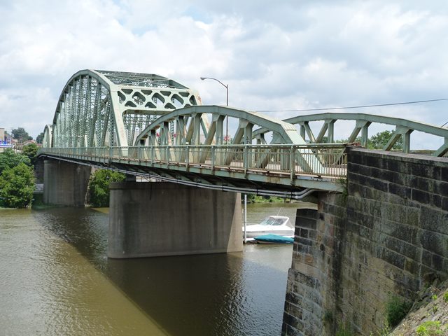
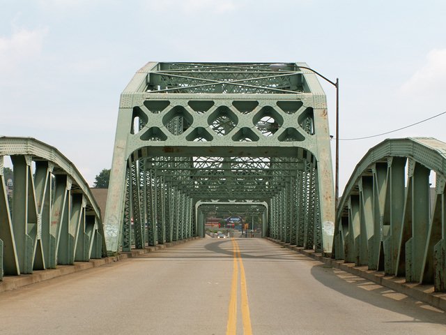
This is a very impressive Parker through truss with a pony truss approach span. The Rochester-Bridgewater Bridge has excellent historic integrity with no noteworthy alterations. This bridge's unusual span arrangement from east to west consists of a short through truss span, long through truss span, and pony truss span. Local urban legend apparently claims that this design was to make the bridge look like the shape of a beaver, since it crosses the Beaver River. This is likely just a tale. The design of each span is a result of what the bridge is crossing which includes both the Beaver River and a railroad.
The bridge's spans follow 1930s state standard designs for truss bridges. This bridge's three spans are an excellent patternbook for the most commonly used standard truss designs in Pennsylvania in the 1930s. The short/small Parker truss span, with its use of rolled beams for vertical and diagonal members, represents the design that the state used for medium span crossings. The long/large Parker truss span, with use of built-up beams including v-lacing for vertical and diagonal members, is representative of the design the state reserved for longer spans. Finally, the pony truss span is a typical example of a standard short-span truss bridge as designed by the state's highway department. The pony truss, like the small Parker truss span, uses rolled beams for vertical and diagonal members.
While the outdated Pennsylvania Historic Bridge Inventory blindly calls all of Pennsylvania's massive-membered bridges bridges standard and common, these fast-disappearing bridges are anything but common on today's roadways. Michigan for example has not a single bridge remaining that is like Pennsylvania's massive-membered state standard plan bridges, and so not only are they uncommon these days on Pennsylvania roads, they are even less common out-of-state. Plus, although these bridges were indeed clearly built to a standard plan, these bridges varied greatly from bridge to bridge, in terms of design, appearance, and setting. Factors influencing these differences include when the bridge was built, since standard plans were often updated to meet current needs, and span configuration for the obstacle being crosses. For instance, the Rochester-Bridgewater Bridge was built to the same plan as the Tidioute Bridge, or the Parker Bridge. However, the Parker Bridge is noted for a steep grade, the Tidioute Bridge is noted for a scenic setting, and the Rochester-Bridgewater Bridge is noted for a pony truss approach. Modern standard plan bridges do not display such variety.
The western end of the bridge rests on an elaborate stone abutment that appears to be from a previous bridge. The remaining piers and abutments are concrete. There is an unused stone pier at the east end of the bridge that might be from the same previous bridge. It may be that the current bridge crosses at a slightly different angle than the previous bridge, so only the western abutment could be reused.

Information and Findings From Pennsylvania's Historic Bridge InventoryDiscussion of Bridge The 3 span, 648' long and 35' wide bridge is composed of a 350'-long, riveted Parker thru truss main span, a shorter Parker thru truss east approach span over the railroad, and a Parker pony truss west approach span. Portions of the stone substructure from an earlier bridge are incorporated into the concrete substructure. The bridge dates to 1933, and all truss spans are traditionally composed with rolled section web members. There are no innovative or distinctive details, and the design is typical of what the department was using for major crossings in the 1930s. Neither the bridge nor its setting is historically or technologically significant. The bridge was built to enhance vehicular operations, not the efficiency of the railroad. It is also not the first grade crossing elimination bridge at this site. Discussion of Surrounding Area The bridge carries a two-lane street over the Beaver River and four Conrail (formerly PA RR main line) tracks at the confluence with the Ohio River. There is modern commercial development at the east end of the bridge, and the west end has predominately 20th century buildings, although there are some 19th century structures. The area does not have historic district potential. The line is the Fort Wayne division of the of the PA RR that PHMC determined eligible 9/14/93, but no period of significance or definition of contributing and noncontributing resources was part of the determination. Bridge Considered Historic By Survey: No |
![]()
![]()
![]()
![]()
![]()

![]()
Coordinates (Latitude, Longitude):
Search For Additional Bridge Listings:
Bridgehunter.com: View listed bridges within 0.5 miles (0.8 kilometers) of this bridge.
Bridgehunter.com: View listed bridges within 10 miles (16 kilometers) of this bridge.
Additional Maps:
Google Streetview (If Available)
GeoHack (Additional Links and Coordinates)
Apple Maps (Via DuckDuckGo Search)
Apple Maps (Apple devices only)
Android: Open Location In Your Map or GPS App
Flickr Gallery (Find Nearby Photos)
Wikimedia Commons (Find Nearby Photos)
Directions Via Sygic For Android
Directions Via Sygic For iOS and Android Dolphin Browser
USGS National Map (United States Only)
Historical USGS Topo Maps (United States Only)
Historic Aerials (United States Only)
CalTopo Maps (United States Only)

© Copyright 2003-2026, HistoricBridges.org. All Rights Reserved. Disclaimer: HistoricBridges.org is a volunteer group of private citizens. HistoricBridges.org is NOT a government agency, does not represent or work with any governmental agencies, nor is it in any way associated with any government agency or any non-profit organization. While we strive for accuracy in our factual content, HistoricBridges.org offers no guarantee of accuracy. Information is provided "as is" without warranty of any kind, either expressed or implied. Information could include technical inaccuracies or errors of omission. Opinions and commentary are the opinions of the respective HistoricBridges.org member who made them and do not necessarily represent the views of anyone else, including any outside photographers whose images may appear on the page in which the commentary appears. HistoricBridges.org does not bear any responsibility for any consequences resulting from the use of this or any other HistoricBridges.org information. Owners and users of bridges have the responsibility of correctly following all applicable laws, rules, and regulations, regardless of any HistoricBridges.org information.
![]()