We Recommend:
Bach Steel - Experts at historic truss bridge restoration.
BridgeHunter.com Phase 1 is released to the public! - Visit Now
Kelly Road Bridge
Canal Road Bridge

Primary Photographer(s): Nathan Holth and Rick McOmber
Bridge Documented: July 1, 2006, August 21, 2010, and October 1, 2021
Sharpsville: Mercer County, Pennsylvania: United States
1897 By Builder/Contractor: Penn Bridge Company of Beaver Falls, Pennsylvania
Not Available or Not Applicable
179.0 Feet (54.6 Meters)
187.0 Feet (57 Meters)
16 Feet (4.88 Meters)
1 Main Span(s)
437303038823040

View Information About HSR Ratings
Bridge Documentation
This bridge no longer exists!
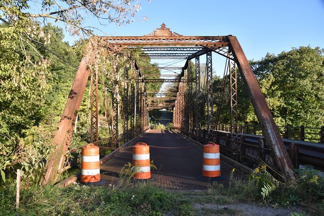
Bridge Status: Demolished in December 2021: Only 2 panels of the truss will be relocated and preserved nearby as an exhibit!This bridge is an eleven panel pin connected structure. While the configuration is listed in the Historic Bridge Inventory as a Parker, because it has five angles making up the top chord/end post, the bridge is actually a more rare variation of the Parker known as a Camelback truss. There is extensive v-lacing and lattice on the structure. The deck of the bridge is a metal grate. The bridge retains original builder plaques. An additional bridge was added many years ago next to this bridge to form a one-way couplet of bridges. This eliminates any issues that might be seen with having a one-lane bridge. This bridge is a beautiful structure, and is near to historic canal locks and as such, preserving this bridge makes sense. This bridge has been closed to traffic due to deterioration however. With a one-way couplet arrangement already in place, a project to rehabilitate the historic truss and continue this function is logical. However when it comes to historic bridges in Pennsylvania, logic is often thrown out the window, and that is certainly the case here. This bridge is instead slated for demolition and replacement. The only positive is that the two end panels will be salvaged for display in the nearby park. While this is better than most forms of mitigation, it would have been better to move and preserve the entire bridge. To say nothing of preserving the bridge in place for pedestrian use, given the park setting and trails around the bridge this would have been an excellent choice.
View Archived National Bridge Inventory Report - Has Additional Details and Evaluation

Information and Findings From Pennsylvania's Historic Bridge InventoryDiscussion of Bridge The 1897, pin connected, single span, 187'-long, Parker thru truss bridge is supported on ashlar abutments with flared wingwalls. The polygonal upper chords are built up box sections, the verticals are toe-out channels with lacing, and the diagonals and lower chords are eye bars. The bridge is historically and technologically significant as an early and complete pin connected, Parker thru truss bridge. The technology is rare in Pennsylvania. Approximately 15 pin connected Parker truss highway bridges survive statewide, and only three date from before 1900. Adding to its significance is its association with the Penn Bridge Company, a prolific regional fabricator of metal truss bridges. Discussion of Surrounding Area The bridge carries northbound traffic at the west entrance to the Sharpsville Area Recreation Park, created at the site of Lock No. 10 of the mid 19th century Erie Canal Extension. The abandoned and dewatered canal and stone canal lock chamber is located a short distance south of the bridge. A parallel 2-span, post-1956 stringer bridge carries southbound traffic. Bridge Considered Historic By Survey: Yes Information From www.mercercotrussbridges.com Demolition Mitigation WebsiteDiscussion of Bridge The bridge now carries northbound
traffic only, while a parallel, two-span, post-1956 stringer bridge
carries southbound traffic. The bridge crosses the Shenango River at the
east entrance to the Sharpsville Canal Lock Recreation Park, which has
been created at the site of Lock No. 10 of the mid-19th century Erie
Canal Extension. The abandoned and dewatered canal and stone canal lock
chamber is located a short distance southwest of the bridge.
|
This bridge is tagged with the following special condition(s): Unorganized Photos
![]()
Photo Galleries and Videos: Kelly Road Bridge
Bridge Photo-Documentation
Original / Full Size PhotosA collection of overview and detail photos. This gallery offers photos in the highest available resolution and file size in a touch-friendly popup viewer.
Alternatively, Browse Without Using Viewer
![]()
Bridge Photo-Documentation
Mobile Optimized PhotosA collection of overview and detail photos. This gallery features data-friendly, fast-loading photos in a touch-friendly popup viewer.
Alternatively, Browse Without Using Viewer
![]()
2021 Additional Unorganized Photos
Original / Full Size PhotosA supplemental collection of photos that are from additional visit(s) to the bridge and have not been organized or captioned. This gallery offers photos in the highest available resolution and file size in a touch-friendly popup viewer.
Alternatively, Browse Without Using Viewer
![]()
2021 Additional Unorganized Photos
Mobile Optimized PhotosA supplemental collection of photos that are from additional visit(s) to the bridge and have not been organized or captioned. This gallery features data-friendly, fast-loading photos in a touch-friendly popup viewer.
Alternatively, Browse Without Using Viewer
![]()
Maps and Links: Kelly Road Bridge
This historic bridge has been demolished. This map is shown for reference purposes only.
Coordinates (Latitude, Longitude):
Search For Additional Bridge Listings:
Bridgehunter.com: View listed bridges within 0.5 miles (0.8 kilometers) of this bridge.
Bridgehunter.com: View listed bridges within 10 miles (16 kilometers) of this bridge.
Additional Maps:
Google Streetview (If Available)
GeoHack (Additional Links and Coordinates)
Apple Maps (Via DuckDuckGo Search)
Apple Maps (Apple devices only)
Android: Open Location In Your Map or GPS App
Flickr Gallery (Find Nearby Photos)
Wikimedia Commons (Find Nearby Photos)
Directions Via Sygic For Android
Directions Via Sygic For iOS and Android Dolphin Browser
USGS National Map (United States Only)
Historical USGS Topo Maps (United States Only)
Historic Aerials (United States Only)
CalTopo Maps (United States Only)


