

View Information About HSR Ratings
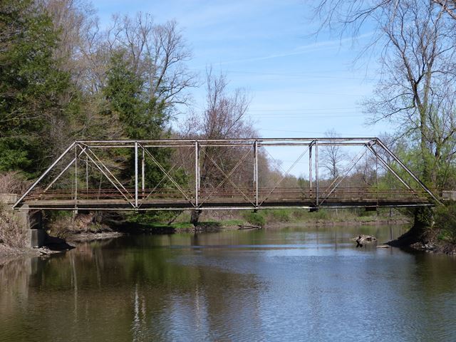
This bridge is a classic example of a bridge built by the Pittsburgh Bridge Company. It is located in a rural setting, and the lightweight truss members blend in nicely with the surrounding trees and creek.
This bridge has been closed to traffic and is owned by PennDOT. Given the trend in Pennsylvania since this website began, this likely means this beautiful historic bridge that could be rehabilitated will instead be demolished. However, given that there are few historic truss bridges remaining in this county, it would be a great time for PennDOT to turn a new page in its track record and choose to preserve this bridge.
Information and Findings From Pennsylvania's Historic Bridge InventoryDiscussion of Bridge The 1889, pin connected, single span, 103'-long, Pratt thru truss bridge is supported on dry laid ashlar abutments. The floorbeams are connected to the lower panel points by Z-shaped hangers, a detail associated with the Pittsburgh Bridge Company, one of the most prolific fabricator of metal truss bridges in the state. One of two pin connected truss bridges in Warren County, the structure is historically and technologically significant as a complete example of its technology. Adding to its significance is its association with the Pittsburgh Bridge Company and its agent, Nelson & Buchanan Company. Discussion of Surrounding Area The bridge carries 1 lane of an unimproved road over a stream in a rural area of undistinguished farmhouses. The setting does not have historic district potential. Bridge Considered Historic By Survey: Yes |
![]()
![]()
![]()
Coordinates (Latitude, Longitude):
Search For Additional Bridge Listings:
Bridgehunter.com: View listed bridges within 0.5 miles (0.8 kilometers) of this bridge.
Bridgehunter.com: View listed bridges within 10 miles (16 kilometers) of this bridge.
Additional Maps:
Google Streetview (If Available)
GeoHack (Additional Links and Coordinates)
Apple Maps (Via DuckDuckGo Search)
Apple Maps (Apple devices only)
Android: Open Location In Your Map or GPS App
Flickr Gallery (Find Nearby Photos)
Wikimedia Commons (Find Nearby Photos)
Directions Via Sygic For Android
Directions Via Sygic For iOS and Android Dolphin Browser
USGS National Map (United States Only)
Historical USGS Topo Maps (United States Only)
Historic Aerials (United States Only)
CalTopo Maps (United States Only)

© Copyright 2003-2026, HistoricBridges.org. All Rights Reserved. Disclaimer: HistoricBridges.org is a volunteer group of private citizens. HistoricBridges.org is NOT a government agency, does not represent or work with any governmental agencies, nor is it in any way associated with any government agency or any non-profit organization. While we strive for accuracy in our factual content, HistoricBridges.org offers no guarantee of accuracy. Information is provided "as is" without warranty of any kind, either expressed or implied. Information could include technical inaccuracies or errors of omission. Opinions and commentary are the opinions of the respective HistoricBridges.org member who made them and do not necessarily represent the views of anyone else, including any outside photographers whose images may appear on the page in which the commentary appears. HistoricBridges.org does not bear any responsibility for any consequences resulting from the use of this or any other HistoricBridges.org information. Owners and users of bridges have the responsibility of correctly following all applicable laws, rules, and regulations, regardless of any HistoricBridges.org information.
![]()