

View Information About HSR Ratings
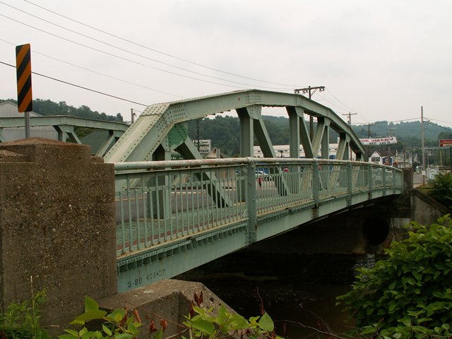
The Central Avenue Bridge is a state standard plan pony truss bridge. It is a seven panel structure, and it retains original sidewalk railings. There is lattice under the top chord of this bridge. The bridge, with its arch-shaped top chord and location as an entrance/exit into Canonsburg creates a fitting gateway for the town. The bridge appears to be in good condition, has a wide roadway, but this still did not stop PennDOT from deciding to demolish and replace this attractive historic bridge.
Information and Findings From Pennsylvania's Historic Bridge InventoryDiscussion of Bridge The single-span, 96'-long and 37' wide steel Parker pony truss bridge is supported on reinforced concrete abutments. Sidewalks with a riveted steel railing are cantilevered off both sides of the bridge that was built to a frequently used state standard design in 1934. It has no innovative or distinctive details. Rolled section was used for web members starting in the late 1920s. Neither the bridge nor its setting are historically or technologically significant. Safety shape barriers have been placed inside the truss lines. Discussion of Surrounding Area The bridge carries a two-lane road with sidewalks over a stream in an area of undistinguished commercial and industrial development in the borough of Canonsburg that has modern commercial structures interspersed among altered early-20th century and post-World War II houses north of the downtown area. The setting does not have historic district potential, and it is not contiguous to the old commercial center. Bridge Considered Historic By Survey: No |
![]()
![]()
![]()
This historic bridge has been demolished. This map is shown for reference purposes only.
Coordinates (Latitude, Longitude):
Search For Additional Bridge Listings:
Bridgehunter.com: View listed bridges within 0.5 miles (0.8 kilometers) of this bridge.
Bridgehunter.com: View listed bridges within 10 miles (16 kilometers) of this bridge.
Additional Maps:
Google Streetview (If Available)
GeoHack (Additional Links and Coordinates)
Apple Maps (Via DuckDuckGo Search)
Apple Maps (Apple devices only)
Android: Open Location In Your Map or GPS App
Flickr Gallery (Find Nearby Photos)
Wikimedia Commons (Find Nearby Photos)
Directions Via Sygic For Android
Directions Via Sygic For iOS and Android Dolphin Browser
USGS National Map (United States Only)
Historical USGS Topo Maps (United States Only)
Historic Aerials (United States Only)
CalTopo Maps (United States Only)

© Copyright 2003-2026, HistoricBridges.org. All Rights Reserved. Disclaimer: HistoricBridges.org is a volunteer group of private citizens. HistoricBridges.org is NOT a government agency, does not represent or work with any governmental agencies, nor is it in any way associated with any government agency or any non-profit organization. While we strive for accuracy in our factual content, HistoricBridges.org offers no guarantee of accuracy. Information is provided "as is" without warranty of any kind, either expressed or implied. Information could include technical inaccuracies or errors of omission. Opinions and commentary are the opinions of the respective HistoricBridges.org member who made them and do not necessarily represent the views of anyone else, including any outside photographers whose images may appear on the page in which the commentary appears. HistoricBridges.org does not bear any responsibility for any consequences resulting from the use of this or any other HistoricBridges.org information. Owners and users of bridges have the responsibility of correctly following all applicable laws, rules, and regulations, regardless of any HistoricBridges.org information.
![]()