We Recommend:
Bach Steel - Experts at historic truss bridge restoration.
BridgeHunter.com Phase 1 is released to the public! - Visit Now
County Park Road Bridge

Primary Photographer(s): Elaine Deutsch
Bridge Documented: 2009
Rural: Chester County, Pennsylvania: United States
1908 By Builder/Contractor: Corcoran Construction Company of West Chester, Pennsylvania and Engineer/Design: Nathan R. Rambo
Not Available or Not Applicable
47.0 Feet (14.3 Meters)
144.0 Feet (43.9 Meters)
16 Feet (4.88 Meters)
4 Main Span(s)
15701500100325

View Information About HSR Ratings
Bridge Documentation
View Archived National Bridge Inventory Report - Has Additional Details and Evaluation
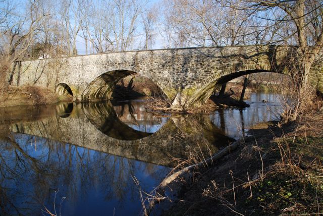
This impressive arch bridge sits in a park setting today, where it may be freely enjoyed by the public. It appears to retain good historic integrity, and is among the larger of the stone arch bridges in the county.
Information and Findings From Pennsylvania's Historic Bridge InventoryDiscussion of Bridge The four-span, 144'-long, stone arch bridge, built in 1908, consists of two larger spans over the creek and two smaller overflow end spans. It has fieldstone spandrel walls and parapets with slate coping. It is supported on stone abutments and piers. The wingwalls are slightly flared and have parapets enclosing the approaches. The bridge has recently been repointed in a historically appropriate manner. It is a large, handsome, and complete example of a bridge type that is common from the first two decades of the 20th century in Chester County. It is the oldest identified of at least 19 county-built stone arch bridges from 1908 to 1919, and thus it reflects the beginning of a brief period of time when the traditional stone arch bridge type enjoyed a revival in the county. The bridge type was favored by County Engineer Nathan R. Rambo, who served from 1899 to 1922. This example was built under the auspices of the Directors of the Poor, who maintained the bridge on the grounds of the county poor house. The bridge is historically and technologically distinguished in the local context. Discussion of Surrounding Area The bridge carries a 2 lane road over a stream on a piece of property that is being developed as a county park. The bridge is not currently open to public access, but will be once the park is opened. The bridge is on the former property of the old Embreeville State Hospital, which before 1939 was the county poor house. The main buildings are located more than one mile to the northeast. The grounds were, and still are, used as a working farm. Cultivated fields are located to the south of the bridge. To the north is the intersection with SR 162. At the bridge's northeast quadrant is a mid-20th-century brick filtration plant, associated with the hospital. Further research is necessary to determine if the hospital has the integrity of a potential historic district. Bridge Considered Historic By Survey: Yes Information and Findings From Pennsylvania's Stone Arch Bridge Management PlanDiscussion of Bridge This bridge is an excellent candidate for long-term preservation. It is among the highest ranking of all stone arch bridges under study in this plan. It is rated as high or very high in five of seven categories. This bridge has a high condition code and needs no specific action. Its transportation code is also high, a result of relatively low volumes of traffic and very good sight distance approaching the bridge. Set in an area of low development potential, the bridge will likely be able to carry its traffic for some time to come, despite its narrow width. Its waterway is adequate. The bridge has historic integrity, making the cost to rehabilitate relatively inexpensive. The bridge has been determined individually eligible for listing in the National Register of Historic Places, is in a park, and is locally and regionally significant, resulting in a high values code. The bridge has public support (one letter, four emails, and one meeting at which this bridge was a focus). Ratings The Newlin, County Park Road bridge is owned by
Chester County and is ranked 7th. Recommendation: A strong candidate for long-term preservation. |
![]()
Photo Galleries and Videos: County Park Road Bridge
Bridge Photo-Documentation
Original / Full Size PhotosA collection of overview and detail photos. This gallery offers photos in the highest available resolution and file size in a touch-friendly popup viewer.
Alternatively, Browse Without Using Viewer
![]()
Bridge Photo-Documentation
Mobile Optimized PhotosA collection of overview and detail photos. This gallery features data-friendly, fast-loading photos in a touch-friendly popup viewer.
Alternatively, Browse Without Using Viewer
![]()
Maps and Links: County Park Road Bridge
Coordinates (Latitude, Longitude):
Search For Additional Bridge Listings:
Bridgehunter.com: View listed bridges within 0.5 miles (0.8 kilometers) of this bridge.
Bridgehunter.com: View listed bridges within 10 miles (16 kilometers) of this bridge.
Additional Maps:
Google Streetview (If Available)
GeoHack (Additional Links and Coordinates)
Apple Maps (Via DuckDuckGo Search)
Apple Maps (Apple devices only)
Android: Open Location In Your Map or GPS App
Flickr Gallery (Find Nearby Photos)
Wikimedia Commons (Find Nearby Photos)
Directions Via Sygic For Android
Directions Via Sygic For iOS and Android Dolphin Browser
USGS National Map (United States Only)
Historical USGS Topo Maps (United States Only)
Historic Aerials (United States Only)
CalTopo Maps (United States Only)

