

View Information About HSR Ratings
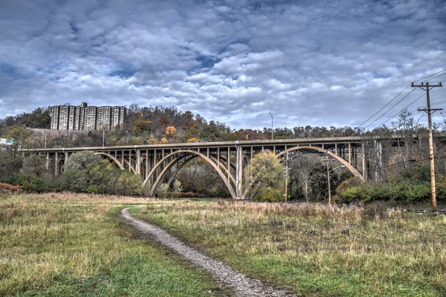
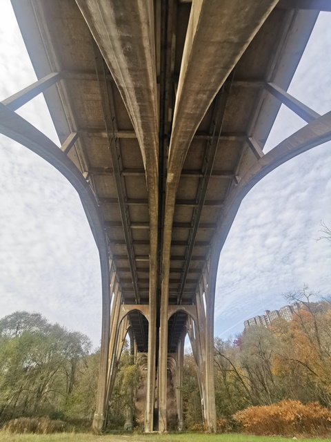
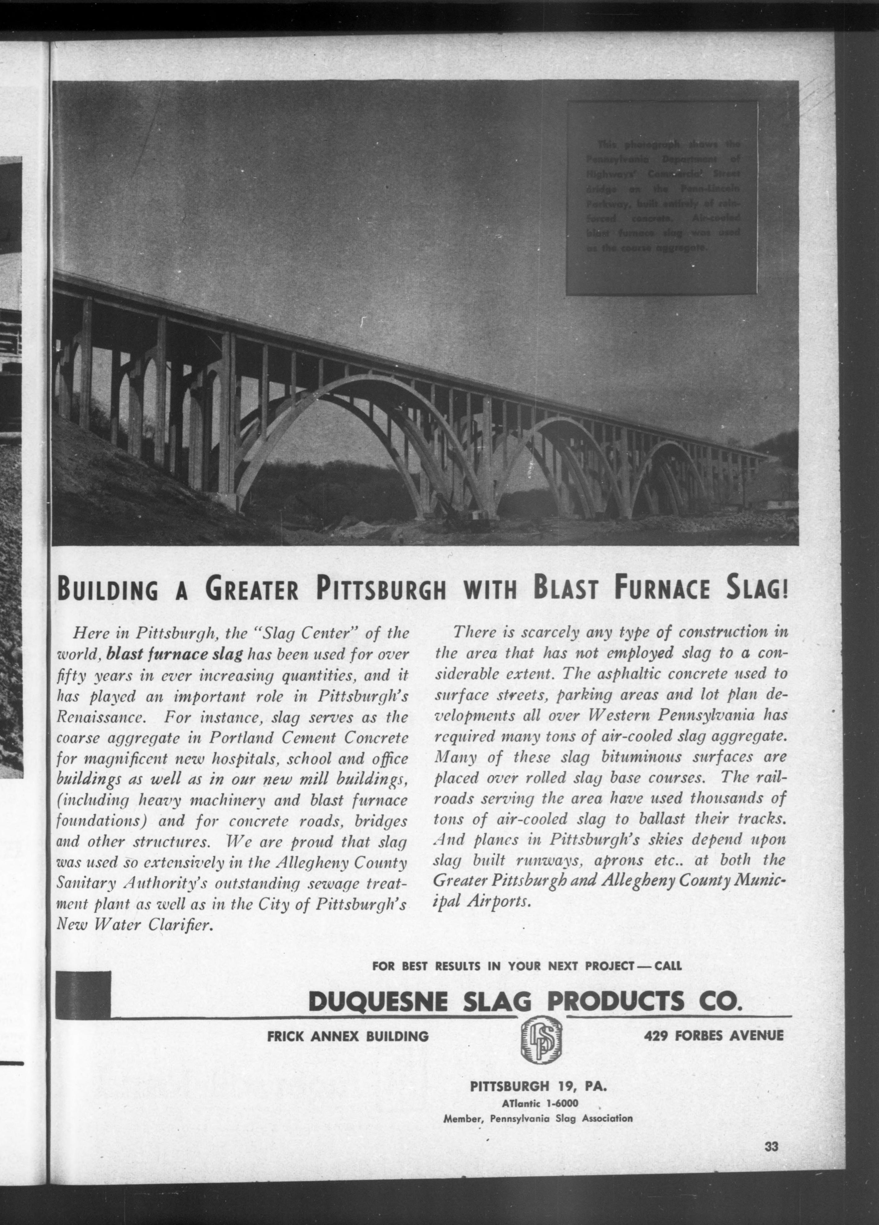
This large concrete arch bridge is configured as two parallel bridges, and is noted for its lack of bracing between arch ribs, giving the bridge an open appearance. The bridge is located a short distance east of the Squirrel Hill Tunnel. One unusual feature in the design of this bridge is that slag material was used in the concrete for this bridge, reportedly provided by the Duquesne Slag Company.
PennDOT provides the following details:
Each structure has 15 spans divided into 5 individual units consisting of 1 western T-Beam approach, 3 central open spandrel arches, and 1 eastern T-Beam approach. Each approach unit contains 6 spans. Each bridge has an overall length of 858’-9” with the following span arrangement:
• 6-span west approach T-Beam unit with 5 spans of 27’-6” and 1 span of 29’-0”
• Single span open spandrel arch of 176’-2”
• Single span open spandrel arch of 175’-3”
• Single span open spandrel arch of 174’-4”
• 6-span east approach T-Beam unit with 1 span of 29’-0” and 5 spans of 27’-6”
Each of the dual bridges has a cross section consisting of a 1’-9” fascia barrier, a 10’-0” outside shoulder, two 12’-0” travel lanes, a 0’-6” inside shoulder, and a 1’-6” median barrier. This results in an out-to-out dimension of 75’-6” for both structures.


Above: 1952 advertisement featuring bridge.
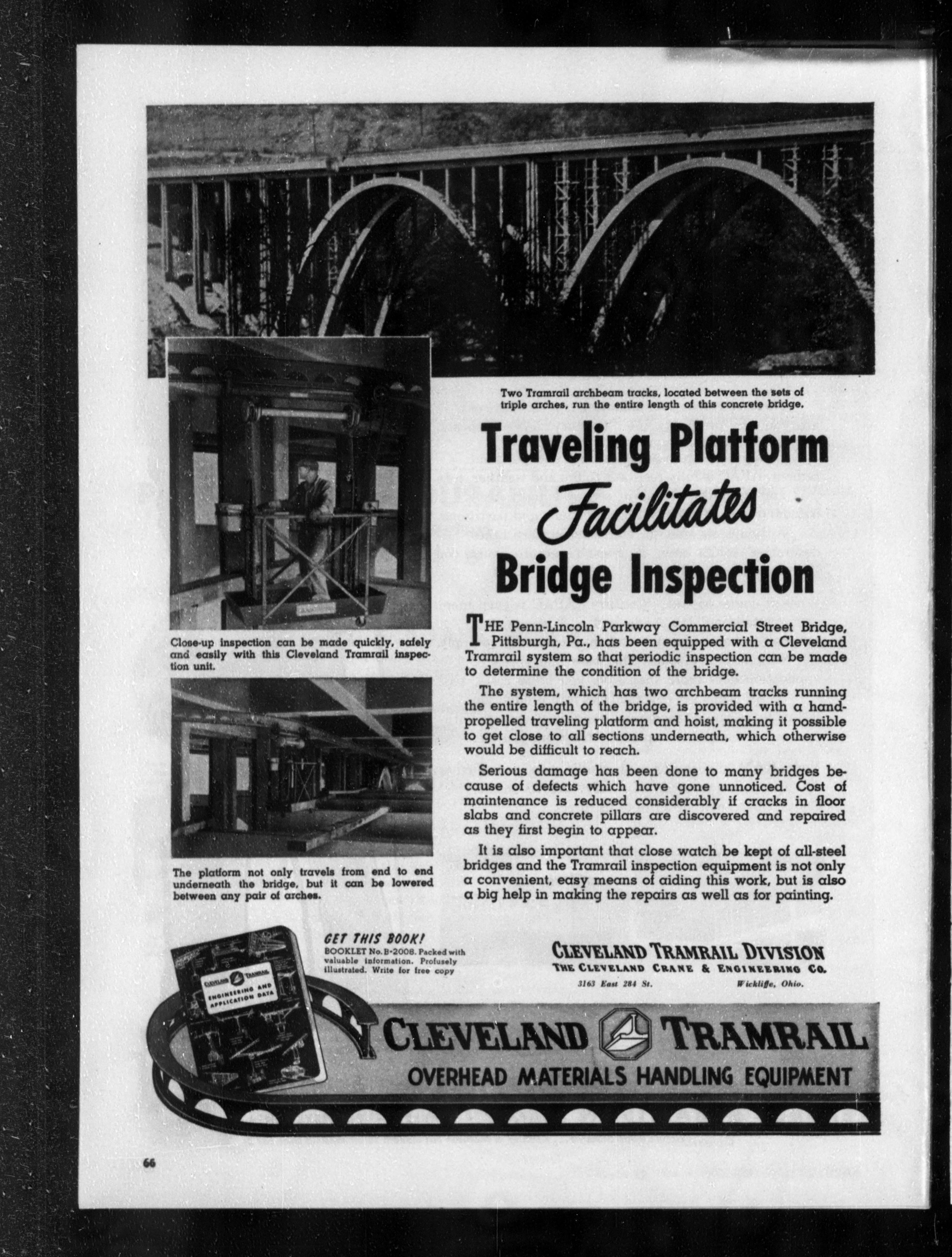
Above: 1954 advertisement featuring bridge.

Above: 1957 advertisement featuring bridge.
Above: 1959 advertisement featuring bridge.
Information and Findings From Pennsylvania's Historic Bridge InventoryDiscussion of Bridge The 15 span, 863'-long bridge built in 1950 is composed of 3 open spandrel arch spans of 170'-long each, and 12 T beam approach spans of approximately 28'-long each. Each arch has 4 ribs with plain spandrel columns supporting floorbeams. There is a longitudinal joint at the center line due to the 71.5' width. The bridge has vertically scored pilasters at the piers, but otherwise architectural details are minimal. Safety shape parapets replaced original railings in 1981. The bridge is a later example of the open spandrel arch bridge technology that was developed during the first decade of the 20th century. It has no individually noteworthy or innovative details. It was chosen for this location based on economy of material, projected low long-term maintenance costs, and aesthetics. Its significance is in association and physical connection with the Penn Lincoln Parkway, a nationally outstanding post-WW II urban expressway project. The parkway and its associated structures are historically and technologically significant. Discussion of Surrounding Area The bridge carries a 4 lane median divided highway over a city street and a stream. The Penn Lincoln Parkway (1946-1960) is an important engineering achievement that is an outstanding example of post-WW II urban expressway planning and design. It required innovative engineering solutions, including the construction of more than 60 bridges, 2 major tunnels, complex interchanges, and the relocation of existing streets and rail lines. The parkway was the largest single project directed by the state highway department up to that time stretching over 19.5 miles in a general east-west direction from US 22 in Churchill to downtown and then west to SR 60 in Robinson Twp. It was built in stages over a period of 14 years mainly to spread out the huge expense. Bridge Considered Historic By Survey: Yes |
![]()
![]()
![]()
Coordinates (Latitude, Longitude):
Search For Additional Bridge Listings:
Bridgehunter.com: View listed bridges within 0.5 miles (0.8 kilometers) of this bridge.
Bridgehunter.com: View listed bridges within 10 miles (16 kilometers) of this bridge.
Additional Maps:
Google Streetview (If Available)
GeoHack (Additional Links and Coordinates)
Apple Maps (Via DuckDuckGo Search)
Apple Maps (Apple devices only)
Android: Open Location In Your Map or GPS App
Flickr Gallery (Find Nearby Photos)
Wikimedia Commons (Find Nearby Photos)
Directions Via Sygic For Android
Directions Via Sygic For iOS and Android Dolphin Browser
USGS National Map (United States Only)
Historical USGS Topo Maps (United States Only)
Historic Aerials (United States Only)
CalTopo Maps (United States Only)

© Copyright 2003-2026, HistoricBridges.org. All Rights Reserved. Disclaimer: HistoricBridges.org is a volunteer group of private citizens. HistoricBridges.org is NOT a government agency, does not represent or work with any governmental agencies, nor is it in any way associated with any government agency or any non-profit organization. While we strive for accuracy in our factual content, HistoricBridges.org offers no guarantee of accuracy. Information is provided "as is" without warranty of any kind, either expressed or implied. Information could include technical inaccuracies or errors of omission. Opinions and commentary are the opinions of the respective HistoricBridges.org member who made them and do not necessarily represent the views of anyone else, including any outside photographers whose images may appear on the page in which the commentary appears. HistoricBridges.org does not bear any responsibility for any consequences resulting from the use of this or any other HistoricBridges.org information. Owners and users of bridges have the responsibility of correctly following all applicable laws, rules, and regulations, regardless of any HistoricBridges.org information.
![]()