

View Information About HSR Ratings
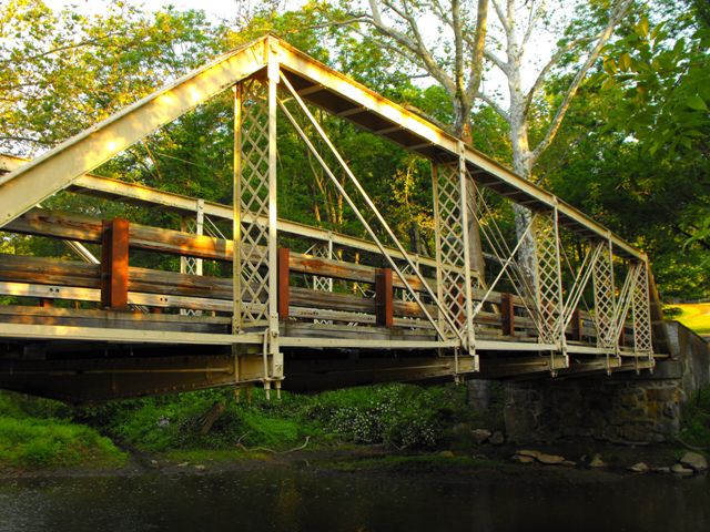
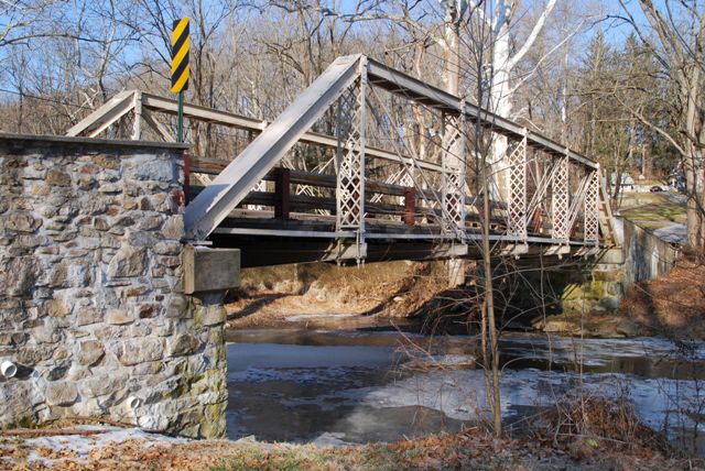
This bridge is a structure with several layers of high historic significance. First, constructed in 1877, this bridge is an extremely early Pratt truss bridge. Second, it is an early surviving work of the prominent and noteworthy Wrought Iron Bridge Company. The bridge is also unusual for the composition of the truss members, notably the vertical members. Rather than a single row of lattice like many bridges would have, this bridge have two rows of lattice. This seemingly simple design change is either extremely rare or unique among similar bridges remaining today. This change also makes the bridge have a different visual appearance from the average Pratt pony truss bridge. The double rows of lattice are contained between rolled "t-bars" which were a design of rolled beam that Wrought Iron Bridge Company references in several patents. These t-bars accomplish the same thing that two rolled angles riveted together often accomplish on other bridges. The bottom chord is not connected to the hip verticals on this bridge, another unusual detail. The floorbeams of this bridge are built-up in the fishbelly style, and they include decorative cast iron caps on the ends, a detail that the Wrought Iron Bridge Company often used on its bridges of the 1870s.
The plaque on this bridge references an April 28 1874 patent, however the only patent found for Wrought Iron Bridge Company's David Hammond under that date is this patent which appears to reference a bridge which looks nothing like this bridge. The plaque may simply be a generic plaque.
This bridge has been rehabilitated and the work includes post-tensioning of members on the bridge. Post-tensioning introduces elements on the bridge which are not original, however it does not remove or alter the original members, and so despite these additions, the historic integrity of the original bridge material remains good. Wooden guardrails on the bridge are mounted on the deck, and as such they are effective at protecting the trusses from collision damage. Very little section loss and pack rust was observed on the bridge during the field visit, and the paint condition was good as well. If the bridge continues to be maintained in this condition it will continue to be a functional crossing for the foreseeable future.
Information and Findings From Pennsylvania's Historic Bridge InventoryDiscussion of Bridge The single-span, pin-connected Pratt pony truss had been found eligible for the National Register by the PHMC. According to county records the bridge was built in 1877. It is noteworthy for the built-up lattice verticals. The fabricator is not specified in the county bridge records. Bridge Considered Historic By Survey: Yes |
![]()
![]()
![]()
![]()
![]()

![]()
![]()
Coordinates (Latitude, Longitude):
Search For Additional Bridge Listings:
Bridgehunter.com: View listed bridges within 0.5 miles (0.8 kilometers) of this bridge.
Bridgehunter.com: View listed bridges within 10 miles (16 kilometers) of this bridge.
Additional Maps:
Google Streetview (If Available)
GeoHack (Additional Links and Coordinates)
Apple Maps (Via DuckDuckGo Search)
Apple Maps (Apple devices only)
Android: Open Location In Your Map or GPS App
Flickr Gallery (Find Nearby Photos)
Wikimedia Commons (Find Nearby Photos)
Directions Via Sygic For Android
Directions Via Sygic For iOS and Android Dolphin Browser
USGS National Map (United States Only)
Historical USGS Topo Maps (United States Only)
Historic Aerials (United States Only)
CalTopo Maps (United States Only)

© Copyright 2003-2026, HistoricBridges.org. All Rights Reserved. Disclaimer: HistoricBridges.org is a volunteer group of private citizens. HistoricBridges.org is NOT a government agency, does not represent or work with any governmental agencies, nor is it in any way associated with any government agency or any non-profit organization. While we strive for accuracy in our factual content, HistoricBridges.org offers no guarantee of accuracy. Information is provided "as is" without warranty of any kind, either expressed or implied. Information could include technical inaccuracies or errors of omission. Opinions and commentary are the opinions of the respective HistoricBridges.org member who made them and do not necessarily represent the views of anyone else, including any outside photographers whose images may appear on the page in which the commentary appears. HistoricBridges.org does not bear any responsibility for any consequences resulting from the use of this or any other HistoricBridges.org information. Owners and users of bridges have the responsibility of correctly following all applicable laws, rules, and regulations, regardless of any HistoricBridges.org information.
![]()