

View Information About HSR Ratings

This bridge is one of several standard plan type truss bridges that tend to date to the 1920s-1940 that are located in or just outside of Johnstown. Bridges like this one are often discarded by historic bridge inventories because they are declared undistinguished and common technology. Indeed, this was certainly the case when they were built. The fact that multiple examples of relatively similar design characteristics remain in Johnstown testifies to that fact. However, these bridges are rapidly being demolished and this is partly due to the fact that these inventories didn't even bother to consider their historic value.
Inventories should look at the fact that some of these older bridges may seem common when the inventory is taken, and then consider that even though this is the case, bridges like this are no longer being built today, and those that survive are being demolished. As such, even if the bridge is not all that rare today, it might be rare soon, and as such it should be declared historic. Perhaps the government should define a third designation for historic bridges that references bridges that are "prospectively rare and historic" meaning that as bridges are demolished, a particular bridge will then become more rare and historic. In addition, one must take into account that these bridges from this era, whether historic or not, are complex and beautiful structures that are a real asset to a city like Johnstown, and are also monuments to a city that was closely associated to the steel industry.
For a city the size of Johnstown, an unusually high number of metal truss bridges remain in the city. For this reason, these bridges should be considered part of a historic group, meaning that while an individual bridge may be of limited significance, the fact that so many are located in one city means that Johnstown is almost like a bridge museum. As such, the preservation of all metal truss bridges in Johnstown should be considered. The town already attracts tourists, particularly those interested in historic. Attractions include the Johnstown Incline Plane and the Cambria steel facilities. Creating a self-guided historic truss bridge tour might be something the city could consider in conjunction with a comprehensive preservation program that would ensure that all of the city's metal truss bridges are preserved. The city could also coordinate with the surrounding area, as a few bridges are located outside of city limits, but are still close enough to fit into this group of historic truss bridges.
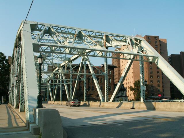
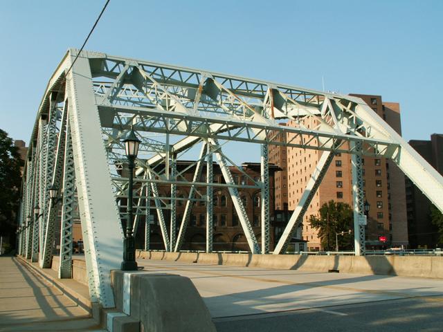
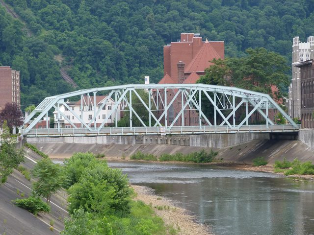
The Franklin Street Bridge displays a polygonal Warren truss configuration making it different from the Parker truss standards that Pennsylvania State Highway Department often used. It also enjoys the benefits of being located in a historic district, and as a result is considered historic by the officials. If you are interested in the history of downtown Johnstown and its buildings, take a look at the National Register of Historic Places Nomination Form for the Historic District in which this bridge is located. Also, the National Bridge Inventory did not provide a valid date for this bridge. However, it is assumed that it was built in 1937 like several other bridges including the nearly identical Hickory Street Bridge in response to the bridges destroyed in the 1936 flood.
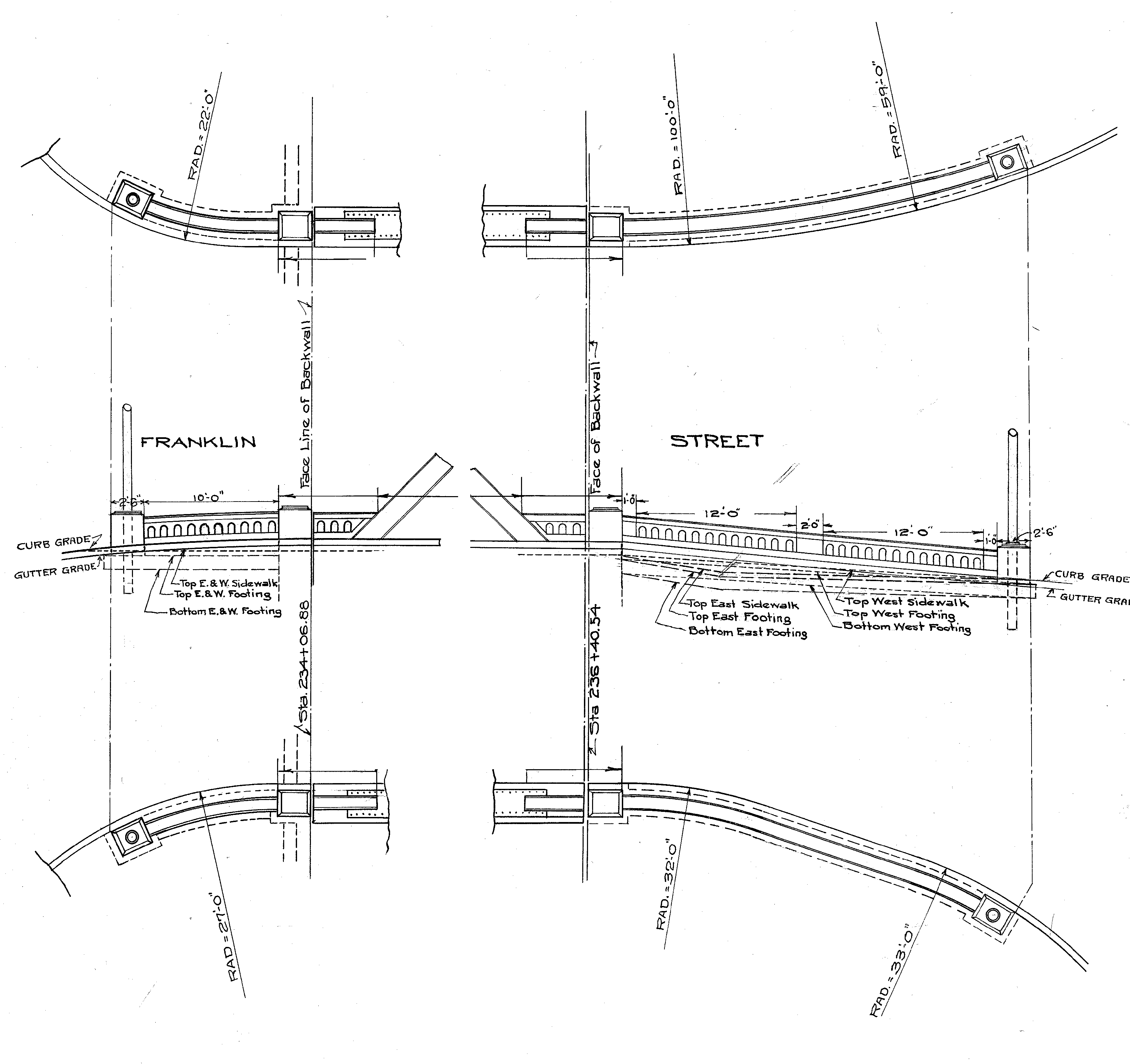
Plans for the bridge show that this bridge originally had an attractive flared balustrade railing system which is today removed. The drawings for these railings are shown below.
![]()
![]()
![]()
![]()
Coordinates (Latitude, Longitude):
Search For Additional Bridge Listings:
Bridgehunter.com: View listed bridges within 0.5 miles (0.8 kilometers) of this bridge.
Bridgehunter.com: View listed bridges within 10 miles (16 kilometers) of this bridge.
Additional Maps:
Google Streetview (If Available)
GeoHack (Additional Links and Coordinates)
Apple Maps (Via DuckDuckGo Search)
Apple Maps (Apple devices only)
Android: Open Location In Your Map or GPS App
Flickr Gallery (Find Nearby Photos)
Wikimedia Commons (Find Nearby Photos)
Directions Via Sygic For Android
Directions Via Sygic For iOS and Android Dolphin Browser
USGS National Map (United States Only)
Historical USGS Topo Maps (United States Only)
Historic Aerials (United States Only)
CalTopo Maps (United States Only)

© Copyright 2003-2026, HistoricBridges.org. All Rights Reserved. Disclaimer: HistoricBridges.org is a volunteer group of private citizens. HistoricBridges.org is NOT a government agency, does not represent or work with any governmental agencies, nor is it in any way associated with any government agency or any non-profit organization. While we strive for accuracy in our factual content, HistoricBridges.org offers no guarantee of accuracy. Information is provided "as is" without warranty of any kind, either expressed or implied. Information could include technical inaccuracies or errors of omission. Opinions and commentary are the opinions of the respective HistoricBridges.org member who made them and do not necessarily represent the views of anyone else, including any outside photographers whose images may appear on the page in which the commentary appears. HistoricBridges.org does not bear any responsibility for any consequences resulting from the use of this or any other HistoricBridges.org information. Owners and users of bridges have the responsibility of correctly following all applicable laws, rules, and regulations, regardless of any HistoricBridges.org information.
![]()