

View Information About HSR Ratings
This bridge is an attractive Pratt truss bridge listed in the National Bridge Inventory as wrought iron. The bridge has unusual top chord and end post built-up beams where the underside only has isolated X patterns and battens rather than the typical repeating pattern of X lattice, v-lacing, or lattice. The design was something that bridge builder John Denithorne and Sons of Phoenixville, Pennsylvania often did, and as such this bridge is assumed to be this company's work.
The historic bridge inventory found this bridge ineligible for listing in the National Register of Historic Places. This finding is clearly outdated and a well-written national register nomination form likely could get the bridge listed in the National Register. The alterations made to the bridge that are mentioned are unfortunate, however a vast majority of the original bridge material and design remains. Further, although the presence of "innovative or distinctive" obviously would increase the significance of the bridge, these are not a requirement for National Register eligibility. Further, the unusual built-up beams on this bridge, which are likely evidence the bridge was built by John Denithorne whose bridges have these unusual built-up beams, should in fact be considered a distinctive detail. Finally, the rarity of truss bridges with pin connections, and especially pre-1900 bridges, and even moreso, with wrought iron truss bridges, all three of which this bridge is, should be automatically considered historic unless the majority of original bridge material and design is missing, which is not even remotely the case with this bridge. This bridge should be considered historic, without hesitation.
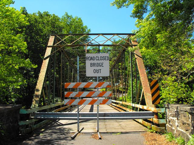
Montgomery County supposedly originally planned to build a new bridge on a different alignment and then leave the historic bridge standing next to its replacement for pedestrian use. This solution was an excellent preservation alternative that would have met the needs of motor vehicles in the area, provided non-motorized traffic with a functional crossing, and preserved an important and beautiful historic bridge. However, Montgomery County hired Bursich Associates to inspect the bridge and provide an assessment of the bridge for preservation feasibility. Bursich looked at the bridge and found that "the bridge had sustained damage to its truss system causing a deflection in the structure" and based on that were advised that preservation would be costly and difficult, and as such now the county plans to demolish the historic bridge, even though it will not be in the way of its replacement. HistoricBridges.org does not question that there may be a problem with the bridge that would require repair, however, HistoricBridges.org does question the assessment that fixing it would not be feasible. HistoricBridges.org always recommends that anyone who has a historic bridge and wants to have it assessed always seek out a firm that has repeated and proven experience with historic bridge preservation. Many firms do not have an intimate understanding of how historic bridges function, nor are they aware of the many resources available for preservation of historic bridges, resources which often mean the difference between a costly restoration and an inexpensive restoration. Bursich Associates is undoubtedly a fantastic firm to hired to design a new bridge, and they probably do a great job at that, but HistoricBridges.org reviewed their website and could not find a portfolio detailing the firm's experience with historic metal truss bridges. Bursich may instead be one of the many firms who would describe hot metal riveting as a "lost art" and say it cannot be done on restoration work, even as numerous historic bridges in a number of states have been restored with the use of hot metal riveting. In contrast, firms like J. A. Barker Engineering or Sparks Engineering, specialize in rehabilitation and historic bridges and would be better qualified to offer the least expensive and most effective preservation solution for a historic bridge.
Information and Findings From Pennsylvania's Historic Bridge InventoryDiscussion of Bridge The single span, 114'-long and 17'-wide, pin connected, Pratt thru truss bridge is traditionally composed with the built up box section upper chords and inclined end posts using X pattern bars instead of the lacing. The verticals are angles with a laced web, and the diagonals and lower chords are eye bars. In 1981 the bridge has been strengthened by welding additional members. It is attributed to John Denithorne based on the design of the built up box section upper chords and end posts and sizes of the eye bars. Denithorne was a prolific builder of metal truss bridges in the region, and there are several complete and earlier examples of his work in Montgomery County, including 46 7046 0620 0059. This example is later, does not have any innovative or distinctive details, and has been altered with additional members welded to it. It is not historically or technologically significant because of its alterations. Discussion of Surrounding Area The bridge carries a 2 lane road over a stream in a rural area that has many modern houses interspersed with farms. The area does not have the cohesiveness to be a rural historic district because of the number of intrusions. Bridge Considered Historic By Survey: Yes |
![]()
![]()
![]()
This historic bridge has been demolished. This map is shown for reference purposes only.
Coordinates (Latitude, Longitude):
Search For Additional Bridge Listings:
Bridgehunter.com: View listed bridges within 0.5 miles (0.8 kilometers) of this bridge.
Bridgehunter.com: View listed bridges within 10 miles (16 kilometers) of this bridge.
Additional Maps:
Google Streetview (If Available)
GeoHack (Additional Links and Coordinates)
Apple Maps (Via DuckDuckGo Search)
Apple Maps (Apple devices only)
Android: Open Location In Your Map or GPS App
Flickr Gallery (Find Nearby Photos)
Wikimedia Commons (Find Nearby Photos)
Directions Via Sygic For Android
Directions Via Sygic For iOS and Android Dolphin Browser
USGS National Map (United States Only)
Historical USGS Topo Maps (United States Only)
Historic Aerials (United States Only)
CalTopo Maps (United States Only)

© Copyright 2003-2026, HistoricBridges.org. All Rights Reserved. Disclaimer: HistoricBridges.org is a volunteer group of private citizens. HistoricBridges.org is NOT a government agency, does not represent or work with any governmental agencies, nor is it in any way associated with any government agency or any non-profit organization. While we strive for accuracy in our factual content, HistoricBridges.org offers no guarantee of accuracy. Information is provided "as is" without warranty of any kind, either expressed or implied. Information could include technical inaccuracies or errors of omission. Opinions and commentary are the opinions of the respective HistoricBridges.org member who made them and do not necessarily represent the views of anyone else, including any outside photographers whose images may appear on the page in which the commentary appears. HistoricBridges.org does not bear any responsibility for any consequences resulting from the use of this or any other HistoricBridges.org information. Owners and users of bridges have the responsibility of correctly following all applicable laws, rules, and regulations, regardless of any HistoricBridges.org information.
![]()