

View Information About HSR Ratings
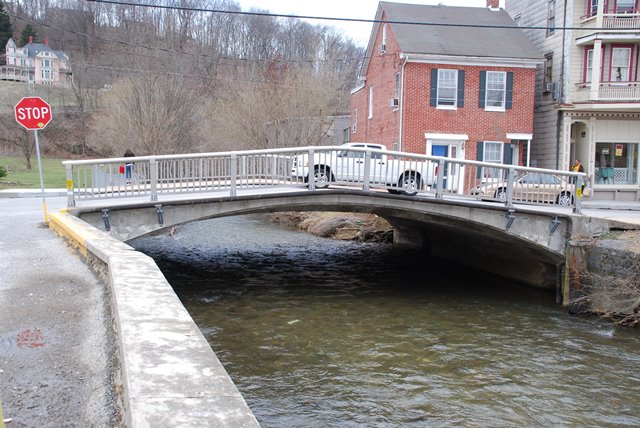
Although altered this tiny concrete arch bridge contributes to a historic district.
Information and Findings From Pennsylvania's Historic Bridge InventoryDiscussion of Bridge The 1-span, 42'-long reinforced concrete arch bridge built in 1915 has been altered by replacement tubular metal railings (ca. 1970). An uncommon feature is the variable depth of the arch barrel, which is shallower for the sidewalks. It is an original detail to save material and not a later alteration. The bridge is not an early or innovative example of a bridge type that was in widespread use by the 1910s, but it is located in a NR-listed historic district and it is from the district's period of significance. The Glen Rock Historic District nomination identifies the bridge as noncontributing based on an incorrect date of construction of ca. 1970 (probably based on a visual inspection of the metal railings). The arch bridge, however, is clearly an earlier structure, and the date of 1915 provided by PADOT BMS and inspection files is appropriate. The bridge has been altered by loss of the railings, and although not individually distinguished, it retains its original arch profile and contributes to the character and significance of its setting. It is evaluated a contributing resource. Discussion of Surrounding Area The bridge carries a 2 lane street and 2 sidewalks over a stream in a setting of predominantly 19th and early 20th century commercial, civic, and residential buildings in Glen Rock. The bridge is in the NR-listed Glen Rock Historic District (5/30/97). Bridge Considered Historic By Survey: Yes |
This bridge is tagged with the following special condition(s): Unorganized Photos
![]()
![]()
![]()
Coordinates (Latitude, Longitude):
Search For Additional Bridge Listings:
Bridgehunter.com: View listed bridges within 0.5 miles (0.8 kilometers) of this bridge.
Bridgehunter.com: View listed bridges within 10 miles (16 kilometers) of this bridge.
Additional Maps:
Google Streetview (If Available)
GeoHack (Additional Links and Coordinates)
Apple Maps (Via DuckDuckGo Search)
Apple Maps (Apple devices only)
Android: Open Location In Your Map or GPS App
Flickr Gallery (Find Nearby Photos)
Wikimedia Commons (Find Nearby Photos)
Directions Via Sygic For Android
Directions Via Sygic For iOS and Android Dolphin Browser
USGS National Map (United States Only)
Historical USGS Topo Maps (United States Only)
Historic Aerials (United States Only)
CalTopo Maps (United States Only)

© Copyright 2003-2026, HistoricBridges.org. All Rights Reserved. Disclaimer: HistoricBridges.org is a volunteer group of private citizens. HistoricBridges.org is NOT a government agency, does not represent or work with any governmental agencies, nor is it in any way associated with any government agency or any non-profit organization. While we strive for accuracy in our factual content, HistoricBridges.org offers no guarantee of accuracy. Information is provided "as is" without warranty of any kind, either expressed or implied. Information could include technical inaccuracies or errors of omission. Opinions and commentary are the opinions of the respective HistoricBridges.org member who made them and do not necessarily represent the views of anyone else, including any outside photographers whose images may appear on the page in which the commentary appears. HistoricBridges.org does not bear any responsibility for any consequences resulting from the use of this or any other HistoricBridges.org information. Owners and users of bridges have the responsibility of correctly following all applicable laws, rules, and regulations, regardless of any HistoricBridges.org information.
![]()