

View Information About HSR Ratings
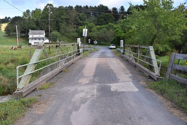
This is an outstanding, unaltered example of a small pony truss built by the famous King Bridge Company. The bridge includes original gaspipe railing. The findings of the historic bridge inventory that this bridge is not historic should be considered outdated. In the time since the inventory was completed, surviving examples of the King Bridge Company have been demolished and this bridge is an increasingly rare example of this important builder, and is further noted for its lack of alteration. The bridge is also noted for its skew, which is rare among pin-connected truss bridges.
Information and Findings From Pennsylvania's Historic Bridge InventoryDiscussion of Bridge The one-span, 31'-long, pin-connected Pratt truss bridge fabricated in 1897 is composed of standard built-up members and eye bars. Prior to 1973, the steel stringers and timber deck were replaced. They no longer bear on the truss floorbeams. The northern stone abutment was completely replaced with a concrete abutment after flood damage in 1972. The truss bearings have been encased in concrete. The alterations to this short-span truss bridge are intrusive and constitute a significant loss of integrity of original design. Numerous unaltered examples of the popular late-19th-century truss type and design have been identified in Northumberland County and the region. Discussion of Surrounding Area The bridge carries a 1 lane road over a stream in a rural area of active farms. The setting does not appear to have historic district potential. Bridge Considered Historic By Survey: No |
![]()
![]()
![]()
Coordinates (Latitude, Longitude):
Search For Additional Bridge Listings:
Bridgehunter.com: View listed bridges within 0.5 miles (0.8 kilometers) of this bridge.
Bridgehunter.com: View listed bridges within 10 miles (16 kilometers) of this bridge.
Additional Maps:
Google Streetview (If Available)
GeoHack (Additional Links and Coordinates)
Apple Maps (Via DuckDuckGo Search)
Apple Maps (Apple devices only)
Android: Open Location In Your Map or GPS App
Flickr Gallery (Find Nearby Photos)
Wikimedia Commons (Find Nearby Photos)
Directions Via Sygic For Android
Directions Via Sygic For iOS and Android Dolphin Browser
USGS National Map (United States Only)
Historical USGS Topo Maps (United States Only)
Historic Aerials (United States Only)
CalTopo Maps (United States Only)

© Copyright 2003-2026, HistoricBridges.org. All Rights Reserved. Disclaimer: HistoricBridges.org is a volunteer group of private citizens. HistoricBridges.org is NOT a government agency, does not represent or work with any governmental agencies, nor is it in any way associated with any government agency or any non-profit organization. While we strive for accuracy in our factual content, HistoricBridges.org offers no guarantee of accuracy. Information is provided "as is" without warranty of any kind, either expressed or implied. Information could include technical inaccuracies or errors of omission. Opinions and commentary are the opinions of the respective HistoricBridges.org member who made them and do not necessarily represent the views of anyone else, including any outside photographers whose images may appear on the page in which the commentary appears. HistoricBridges.org does not bear any responsibility for any consequences resulting from the use of this or any other HistoricBridges.org information. Owners and users of bridges have the responsibility of correctly following all applicable laws, rules, and regulations, regardless of any HistoricBridges.org information.
![]()