

View Information About HSR Ratings
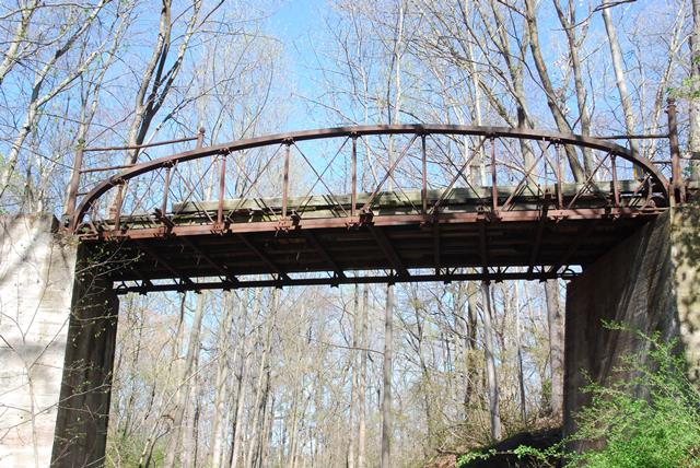
This bridge is one of three similar bridges remaining in the country, one other being in storage and the third being the Watkins Glen Bridge, this is one of only two that features distinctive shaped cast iron vertical members. The Watkins Glen Bridge is the one that doesn't have the shaped vertical members, and instead has pipes for vertical members. Fabricated in the shops of the Philadelphia and Reading Railroad under the direction of John L. Foreman, these bridges have unusual design, typical of the early metal truss bowstring bridges of the 1870s. Built in 1881, this is a late example, but retains the experimental character of the bowstring bridges that were popular in the United States in the 1870s.
The use of a rolled beam for the top chord gives the bridge an almost modern look to it, and is quite a contrast to the shaped cast iron vertical members which make the bridge look decades older than an 1881 bridge. Typical of bowstring truss bridges from this period, the bridge has cast iron connection assemblies, following a design unique to the builder of the bridge and not shared by bowstrings built by other bridge builders. This is one of the many reasons why iron bowstring bridges from this period are so significant: each builder had their own unique design.
The bridge also includes ornamental braces at the ends of the top chord.
Please review the HAER documentation for further information on this highly significant bridge.
![]()
![]()
![]()
This bridge is on a very primitive hiking trail.
Coordinates (Latitude, Longitude):
Search For Additional Bridge Listings:
Bridgehunter.com: View listed bridges within 0.5 miles (0.8 kilometers) of this bridge.
Bridgehunter.com: View listed bridges within 10 miles (16 kilometers) of this bridge.
Additional Maps:
Google Streetview (If Available)
GeoHack (Additional Links and Coordinates)
Apple Maps (Via DuckDuckGo Search)
Apple Maps (Apple devices only)
Android: Open Location In Your Map or GPS App
Flickr Gallery (Find Nearby Photos)
Wikimedia Commons (Find Nearby Photos)
Directions Via Sygic For Android
Directions Via Sygic For iOS and Android Dolphin Browser
USGS National Map (United States Only)
Historical USGS Topo Maps (United States Only)
Historic Aerials (United States Only)
CalTopo Maps (United States Only)

© Copyright 2003-2026, HistoricBridges.org. All Rights Reserved. Disclaimer: HistoricBridges.org is a volunteer group of private citizens. HistoricBridges.org is NOT a government agency, does not represent or work with any governmental agencies, nor is it in any way associated with any government agency or any non-profit organization. While we strive for accuracy in our factual content, HistoricBridges.org offers no guarantee of accuracy. Information is provided "as is" without warranty of any kind, either expressed or implied. Information could include technical inaccuracies or errors of omission. Opinions and commentary are the opinions of the respective HistoricBridges.org member who made them and do not necessarily represent the views of anyone else, including any outside photographers whose images may appear on the page in which the commentary appears. HistoricBridges.org does not bear any responsibility for any consequences resulting from the use of this or any other HistoricBridges.org information. Owners and users of bridges have the responsibility of correctly following all applicable laws, rules, and regulations, regardless of any HistoricBridges.org information.
![]()