

View Information About HSR Ratings
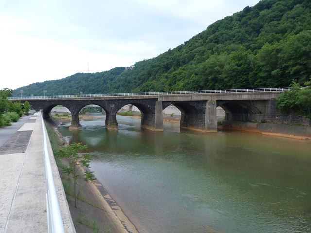
This bridge is a well-known Johnstown landmark. It is significant for multiple reasons. From an engineering standpoint, it is a rare example of a skewed stone arch bridge. The skew is achieved by the offset of the stone ribs of the bridge. The bridge is also noteworthy as the first major stone bridge designed by William H Brown, who went on to design many enormous stone arch bridges for the Pennsylvania Railroad. Brown's choice of stone arch bridges for the railroad during this period in history, which in some cases (including this bridge) resulted in the replacement of pre-existing metal truss bridges with stone bridges, is in reverse to the traditional evolution of bridge materials where typically stone is a material replaced by use of iron and steel.
This bridge was noted as one of the only bridges in Johnstown not destroyed in the great 1889 Johnstown Flood. While this might sound like a good thing, the bridge actually trapped debris flowing down the river, including people. The debris subsequently caught fire and killed the people trapped in the debris before they could be rescued.
The bridge today looks like a concrete arch bridge from the upstream side. This is due to an alteration in 1929. While it appears visually as though the bridge was widened at this time, the bridge was apparently always a four track bridge as seen today, and the concrete section was merely a repair for the flood-damaged upstream side of the bridge.
In contemporary history, the bridge is a recognized historic landmark and a successful effort was completed to provide decorative lighting for the bridge, allowing the bridge to be enjoyed at night as well.

![]()
![]()
![]()
Coordinates (Latitude, Longitude):
Search For Additional Bridge Listings:
Bridgehunter.com: View listed bridges within 0.5 miles (0.8 kilometers) of this bridge.
Bridgehunter.com: View listed bridges within 10 miles (16 kilometers) of this bridge.
Additional Maps:
Google Streetview (If Available)
GeoHack (Additional Links and Coordinates)
Apple Maps (Via DuckDuckGo Search)
Apple Maps (Apple devices only)
Android: Open Location In Your Map or GPS App
Flickr Gallery (Find Nearby Photos)
Wikimedia Commons (Find Nearby Photos)
Directions Via Sygic For Android
Directions Via Sygic For iOS and Android Dolphin Browser
USGS National Map (United States Only)
Historical USGS Topo Maps (United States Only)
Historic Aerials (United States Only)
CalTopo Maps (United States Only)

© Copyright 2003-2026, HistoricBridges.org. All Rights Reserved. Disclaimer: HistoricBridges.org is a volunteer group of private citizens. HistoricBridges.org is NOT a government agency, does not represent or work with any governmental agencies, nor is it in any way associated with any government agency or any non-profit organization. While we strive for accuracy in our factual content, HistoricBridges.org offers no guarantee of accuracy. Information is provided "as is" without warranty of any kind, either expressed or implied. Information could include technical inaccuracies or errors of omission. Opinions and commentary are the opinions of the respective HistoricBridges.org member who made them and do not necessarily represent the views of anyone else, including any outside photographers whose images may appear on the page in which the commentary appears. HistoricBridges.org does not bear any responsibility for any consequences resulting from the use of this or any other HistoricBridges.org information. Owners and users of bridges have the responsibility of correctly following all applicable laws, rules, and regulations, regardless of any HistoricBridges.org information.
![]()