

View Information About HSR Ratings
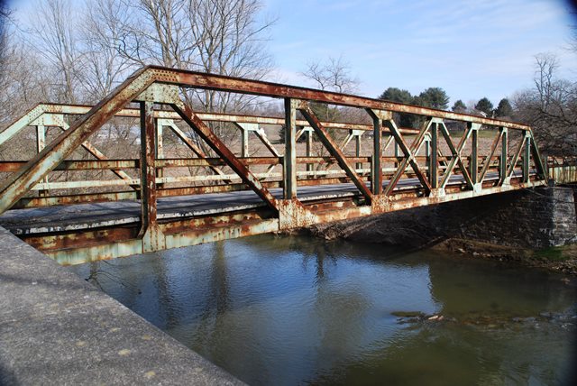
With a listed 1940 construction date, this bridge is a fairly late example of a small pony truss bridge. It is unusual because it also includes a through plate girder span. It sits on a stone substructure which may be from a previous bridge. The bridge appears to be largely unaltered.
Information and Findings From Pennsylvania's Historic Bridge InventoryDiscussion of Bridge The 2-span bridge built in 1940 consists of a 100'-long, rivet-connected Pratt pony truss span and a 54'-long steel thru girder span. The bridge is supported on stone abutments and pier. The truss has built-up chords and end posts, and rolled section diagonals and verticals. Channel railings are set to the inside faces of the trusses and atop the thru girders. Both the rivet-connected Pratt truss and the thru girder are bridge types/designs developed in the 19th century. Numerous examples from the 1890s to 1956 are found throughout the state. This late example has no unusual or noteworthy details. It is not historically or technologically distinguished by its setting or context. Discussion of Surrounding Area The bridge carries a 2 lane road over a stream in a rural setting of active farms and scattered 20th century houses. At the southwest end are a T-shaped intersection with a local road and woods. At the northeast end are open fields and a modern house. The setting does not have the cohesiveness or integrity of a historic district. Bridge Considered Historic By Survey: No |
![]()
![]()
![]()
Coordinates (Latitude, Longitude):
Search For Additional Bridge Listings:
Bridgehunter.com: View listed bridges within 0.5 miles (0.8 kilometers) of this bridge.
Bridgehunter.com: View listed bridges within 10 miles (16 kilometers) of this bridge.
Additional Maps:
Google Streetview (If Available)
GeoHack (Additional Links and Coordinates)
Apple Maps (Via DuckDuckGo Search)
Apple Maps (Apple devices only)
Android: Open Location In Your Map or GPS App
Flickr Gallery (Find Nearby Photos)
Wikimedia Commons (Find Nearby Photos)
Directions Via Sygic For Android
Directions Via Sygic For iOS and Android Dolphin Browser
USGS National Map (United States Only)
Historical USGS Topo Maps (United States Only)
Historic Aerials (United States Only)
CalTopo Maps (United States Only)

© Copyright 2003-2026, HistoricBridges.org. All Rights Reserved. Disclaimer: HistoricBridges.org is a volunteer group of private citizens. HistoricBridges.org is NOT a government agency, does not represent or work with any governmental agencies, nor is it in any way associated with any government agency or any non-profit organization. While we strive for accuracy in our factual content, HistoricBridges.org offers no guarantee of accuracy. Information is provided "as is" without warranty of any kind, either expressed or implied. Information could include technical inaccuracies or errors of omission. Opinions and commentary are the opinions of the respective HistoricBridges.org member who made them and do not necessarily represent the views of anyone else, including any outside photographers whose images may appear on the page in which the commentary appears. HistoricBridges.org does not bear any responsibility for any consequences resulting from the use of this or any other HistoricBridges.org information. Owners and users of bridges have the responsibility of correctly following all applicable laws, rules, and regulations, regardless of any HistoricBridges.org information.
![]()