

View Information About HSR Ratings
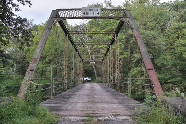
This bridge includes the distinctive ornamental portal bracing of the famous King Bridge Company. It appears as though this bridge may have been abandoned to private ownership. It is not barricaded, however private property signs are visible. The bridge is in a severe state of deterioration, with some diagonal members completely broken off at the heads. If the bridge remained in government ownership it would most certainly be closed to traffic and barricaded off. The bridge is one of the few surviving King Bridge Company through truss bridges in Pennsylvania, due to demolition. The finding of the Historic Bridge Inventory is faulty as they failed to properly identify the builder and the finding is also dated.
Information and Findings From Pennsylvania's Historic Bridge InventoryDiscussion of Bridge The one span, 130' long, pin connected Pratt thru truss bridge is supported on a concrete abutment on the west side and an ashlar abutment on the east side. The bridge plaque documented in the district survey has been lost, but the bridge is recorded as having been built by the Long Bridge Co., which is not listed in Darnell's directory of pre-1901 fabricators. The bridge is traditionally composed. The verticals are toe-in channels with lacing, and the floorbeams are suspended from the lower panel point, but welded straps have been added to augment the connection. The knee braces of the lattice portal brace have punchwork decoration. The bridge is a late example of its type and design, and it has some alterations. It is located in a region noted for its many and complete early pin connected bridges. In comparison with the regional population, this bridge is not historically or technologically significant. Discussion of Surrounding Area The bridge carries one lane of an unimproved township road over a stream in a sparsely developed, forested setting. There are modern and highly altered late-19th and early-20th century houses in the vicinity, which does not appear to have historic district potential. Bridge Considered Historic By Survey: Yes |
![]()
![]()
![]()
Coordinates (Latitude, Longitude):
Search For Additional Bridge Listings:
Bridgehunter.com: View listed bridges within 0.5 miles (0.8 kilometers) of this bridge.
Bridgehunter.com: View listed bridges within 10 miles (16 kilometers) of this bridge.
Additional Maps:
Google Streetview (If Available)
GeoHack (Additional Links and Coordinates)
Apple Maps (Via DuckDuckGo Search)
Apple Maps (Apple devices only)
Android: Open Location In Your Map or GPS App
Flickr Gallery (Find Nearby Photos)
Wikimedia Commons (Find Nearby Photos)
Directions Via Sygic For Android
Directions Via Sygic For iOS and Android Dolphin Browser
USGS National Map (United States Only)
Historical USGS Topo Maps (United States Only)
Historic Aerials (United States Only)
CalTopo Maps (United States Only)

© Copyright 2003-2026, HistoricBridges.org. All Rights Reserved. Disclaimer: HistoricBridges.org is a volunteer group of private citizens. HistoricBridges.org is NOT a government agency, does not represent or work with any governmental agencies, nor is it in any way associated with any government agency or any non-profit organization. While we strive for accuracy in our factual content, HistoricBridges.org offers no guarantee of accuracy. Information is provided "as is" without warranty of any kind, either expressed or implied. Information could include technical inaccuracies or errors of omission. Opinions and commentary are the opinions of the respective HistoricBridges.org member who made them and do not necessarily represent the views of anyone else, including any outside photographers whose images may appear on the page in which the commentary appears. HistoricBridges.org does not bear any responsibility for any consequences resulting from the use of this or any other HistoricBridges.org information. Owners and users of bridges have the responsibility of correctly following all applicable laws, rules, and regulations, regardless of any HistoricBridges.org information.
![]()