

View Information About HSR Ratings
Kevin Beyer provided the following additional information: It was originally built for the Pittsburgh & West Virginia Railroad in the early 1930s. Then in the early 1960s it became part of the N & W system and was the highest bridge on the whole system. In 1990 the railroad was sold to the Wheeling & Lake Erie who owns it now. This bridge is unique in the fact there is a 0 to 0 curve entirely on the bridge.
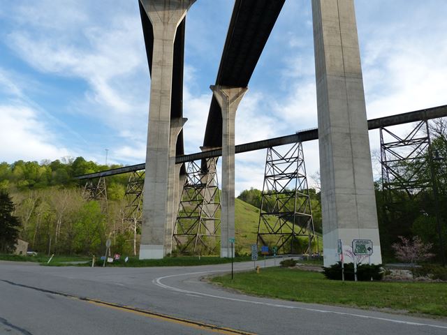
This bridge would normally be instantly viewed as long and tall, except for the enormous PA-43 Bridge that today passes directly over this railroad bridge as PA-43 crosses the Mingo Creek valley. This is a high level railroad bridge. Traditionally composed, it addresses the need for a railroad to cross a valley in the manner of tall steel bents (towers) that support plate girder spans. The bents have a trussed design that gives the bridge an attractive geometry. This geometry is what is so lacking in the PA-43 Bridge that obstructs the view of this historic bridge. According to an article in Modern Steel Construction, The PA-43 Bridge supposedly was recognized as supposedly having been designed to be "in harmony" with the surrounding landscape because of its "repetition of coherent, structurally efficient forms to blend in with the surrounding forest." The massive, solid concrete piers of this bridge actually block the view of both historic bridge and forest, yet still manage to look top-heavy and unstable. The harsh lines of the concrete do not blend in with a forest. In contrast, the open trussed design of the historic bridge with their complex geometry compliments the complex geometry of a tree and its branches, and the open design does not obstruct the view of the forest. Without even trying, the railroad bridge manages to have more substantial aesthetic value than the highway bridge.
![]()
![]()
![]()
Coordinates (Latitude, Longitude):
Search For Additional Bridge Listings:
Bridgehunter.com: View listed bridges within 0.5 miles (0.8 kilometers) of this bridge.
Bridgehunter.com: View listed bridges within 10 miles (16 kilometers) of this bridge.
Additional Maps:
Google Streetview (If Available)
GeoHack (Additional Links and Coordinates)
Apple Maps (Via DuckDuckGo Search)
Apple Maps (Apple devices only)
Android: Open Location In Your Map or GPS App
Flickr Gallery (Find Nearby Photos)
Wikimedia Commons (Find Nearby Photos)
Directions Via Sygic For Android
Directions Via Sygic For iOS and Android Dolphin Browser
USGS National Map (United States Only)
Historical USGS Topo Maps (United States Only)
Historic Aerials (United States Only)
CalTopo Maps (United States Only)

© Copyright 2003-2026, HistoricBridges.org. All Rights Reserved. Disclaimer: HistoricBridges.org is a volunteer group of private citizens. HistoricBridges.org is NOT a government agency, does not represent or work with any governmental agencies, nor is it in any way associated with any government agency or any non-profit organization. While we strive for accuracy in our factual content, HistoricBridges.org offers no guarantee of accuracy. Information is provided "as is" without warranty of any kind, either expressed or implied. Information could include technical inaccuracies or errors of omission. Opinions and commentary are the opinions of the respective HistoricBridges.org member who made them and do not necessarily represent the views of anyone else, including any outside photographers whose images may appear on the page in which the commentary appears. HistoricBridges.org does not bear any responsibility for any consequences resulting from the use of this or any other HistoricBridges.org information. Owners and users of bridges have the responsibility of correctly following all applicable laws, rules, and regulations, regardless of any HistoricBridges.org information.
![]()