We Recommend:
Bach Steel - Experts at historic truss bridge restoration.
BridgeHunter.com Phase 1 is released to the public! - Visit Now
Ohl Street Bridge

Primary Photographer(s): Nathan Holth
Bridge Documented: July 1, 2006
Greenville: Mercer County, Pennsylvania: United States
1909 By Builder/Contractor: Canton Bridge Company of Canton, Ohio
Not Available or Not Applicable
126.0 Feet (38.4 Meters)
256.0 Feet (78 Meters)
29 Feet (8.84 Meters)
2 Main Span(s)
437403881108030

View Information About HSR Ratings
Bridge Documentation
This bridge's future is at risk!
Bridge Status: As of 2019, slated for demolition with no replacement!View Archived National Bridge Inventory Report - Has Additional Details and Evaluation

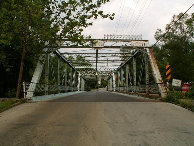
This bridge has a commissioners plaque that is annoyingly obscured by a clearance sign, as if directly in front of the plaque is the only place on a bridge where a clearance sign could be mounted. From what is visible however, the plaque looks similar to the one seen on Ohio's Clarks Mill Road Bridge. The builder for the Ohl Street Bridge has been reported as the Canton Bridge Company of Canton, Ohio. The commissioners plaques and portal cresting do display characteristics of the Canton Bridge Company. The builder plaque itself has been stolen. It was located on top of and in the center of the portal bracing between a gap in the portal cresting.
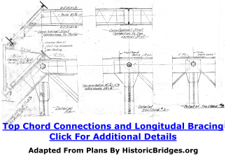
HistoricBridges.org acquired a print copy of a sheet from the original plans from the historic bridge. Some of the more interesting features of this plan sheet are dispersed throughout the narrative below. Clicking on a drawing will enlarge the size and expand the shown detail of that section of the plan sheet.
This bridge is among the more unusual and ornate truss bridges for its age. With its ornate commissioners plaque, highly decorative sidewalk railings, and sunburst portal cresting designs, this truss bridge is a work of art. However, it has one characteristic that makes it stand out as highly unusual, which is its width. For a two-lane bridge, at 29 feet, it is as wide as the extremely wide widths used in modern bridge construction. For its age and design, it looks ridiculously wide. Among its type, this bridge presents a unique opportunity for preservation for continued light vehicular use, without forcing cars onto a narrow one-lane deck width. As a two-lane bridge, this bridge cannot be described as dangerous or inconvenient. It is not functionally obsolete in terms of its deck width. It turns out this bridge was originally designed to support a streetcar, which never came to pass. But, that is indeed why the bridge is so wide. The original design of the bridge even had specially arranged deck stringers to hold the weight of the anticipated street car. The bridge features built-up beams with v-lacing on the verticals and struts. Lattice is present under the top chord, end post, portal bracing, and railings. At the time of documentation, the single sidewalk on the bridge was closed. The sidewalk contains a beautiful, decorative hand railing. Likely because of its wide deck width, the bridge also has a longitudinal strut running down the middle of the bridge, perpendicular to the traditional transverse struts. longitudinal struts are not common on pin-connected Pratt through truss bridges like the Ohl Street Bridge.
Although the current deck of the bridge is a metal grate decking system, the original plans of the bridge show that the bridge was built with a jack-arch deck. A jack-arch deck was a deck type common in the first couple decades of the 20th Century. The jack-arch deck was a deck type featuring curved corrugated metal spanning between deck stringers and filled with concrete above. Because decks are generally replaced throughout a bridge's service life, very few jack-arch decks remain today.
Historically, the bridge is rare in its own right for a two-span length, ornate design, and documented builder. In addition however, it is a bridge located within a potential historic district. This bridge contributes to a neighborhood that is historic in its own right. In other words, this part of town has a historic atmosphere, and the bridge is the central part of that. This, combined with the unusually wide deck width, makes this bridge an excellent candidate for preservation for continued vehicular use.
The bridge has been closed to traffic because of deterioration. Mercer County has been considering the demolition and replacement of this beautiful historic bridge. However upon review of the bridge by HistoricBridges.org, it appears the sections of the bridge with closure-warranting deterioration are isolated areas of the bridge. The overall truss remains in fair condition. As such, rehabilitation for continued vehicular use appears to be very feasible with this bridge. Because of this fact, along with the uniquely wide deck width, this is a rare preservation opportunity that should not be passed by. This bridge should not be demolished and replaced.
Be sure to check out the extensive descriptions and history for this bridge provided by the historic bridge inventory and Mercer County as shown below. Also below are some additional details from the plan sheet of this bridge.
Information and Findings From Pennsylvania's Historic Bridge InventoryDiscussion of Bridge The 1909, pin connected, two span, 256'-long (2 @ 128'), Pratt thru truss bridge is supported on ashlar abutments and an ashlar cutwater pier. The bridge is a complete, handsome example of a pin connected, metal truss bridge with aesthetic details, including cresting and decorative sidewalk railings. It was built by the Canton Bridge Company, a regional fabricator of metal truss bridges. Modifications have been minor, limited to the replacement in 1980 of some floorbeams and stringers, and the strengthening of some truss members by adding cover plate. The bridge also contributes to a potential historic district consisting of the NR-eligible Bessemer & Lake Erie Railroad shops to its east and a working class residential neighborhood to its west. Discussion of Surrounding Area The bridge carries a two lane street and one sidewalk over a stream in a residential/industrial area of Greenville borough. At the southeast quadrant is the Bessemer & Lake Erie Railroad shops and yard, a complex of brick buildings from the early 20th century that PHMC has identified as a potential historic district. On the west side of the bridge is a neighborhood of early 20th century, vernacular residences that may have historic district potential if it developed in association with the shops. The bridge, the link between the two, contributes to the potential historic district. Bridge Considered Historic By Survey: Yes Information From www.mercercotrussbridges.com Demolition Mitigation WebsiteBridge Overview This broad, two-span, Pratt through truss bridge with a cantilevered sidewalk replaced a footbridge in 1909. History of the Construction The construction of the Ohl Street
Bridge, located on the Greenville Borough-Hempfield Township line,
illustrates the planning and construction process of a metal truss
bridge. About The Canton Bridge Company The Canton Bridge Company was
incorporated in 1891. Among the original officers and stockholders was
David Hammond, the "Daddy of steel bridge building in Ohio," who had
previously founded the Wrought Iron Bridge Company. Hammond brought many
of the Wrought Iron Bridge Company's skilled workers to his new concern.
The Canton Bridge Company was a prolific designer and builder of all
types of metal bridges, most notably trusses and through girders. The
Canton Bridge Company operated throughout the eastern half of the
country, with agents from New Jersey to Nebraska. Like most large bridge
fabricators, it maintained an extensive and efficient network of sales
offices and salesmen. Hammond's three sons manned not only the Midwest
offices in Toledo and Canton, but also handled the company's large
Pennsylvania bridge market. In 1901, the Canton Bridge Company built 25
percent of all Ohio bridges and more than 6,000 bridges nationwide. A
1902 American Pictorial Quarterly article noted that the company
built bridges of all sizes, but specialized in "making highway bridges
for the smaller country streams." The same article calls its plant "one
of the most complete in the country." The company also fabricated
turntables and structural ironwork. The Canton Bridge Company ceased
operation in 1925, when it was purchased by the Massillon Steel Joist
Company. |
![]()
Photo Galleries and Videos: Ohl Street Bridge
2006 Bridge Photo-Documentation
A collection of overview and detail photos, taken July 1, 2006. This photo gallery contains a combination of Original Size photos and Mobile Optimized photos in a touch-friendly popup viewer.Alternatively, Browse Without Using Viewer
![]()
Maps and Links: Ohl Street Bridge
Coordinates (Latitude, Longitude):
Search For Additional Bridge Listings:
Bridgehunter.com: View listed bridges within 0.5 miles (0.8 kilometers) of this bridge.
Bridgehunter.com: View listed bridges within 10 miles (16 kilometers) of this bridge.
Additional Maps:
Google Streetview (If Available)
GeoHack (Additional Links and Coordinates)
Apple Maps (Via DuckDuckGo Search)
Apple Maps (Apple devices only)
Android: Open Location In Your Map or GPS App
Flickr Gallery (Find Nearby Photos)
Wikimedia Commons (Find Nearby Photos)
Directions Via Sygic For Android
Directions Via Sygic For iOS and Android Dolphin Browser
USGS National Map (United States Only)
Historical USGS Topo Maps (United States Only)
Historic Aerials (United States Only)
CalTopo Maps (United States Only)


