

View Information About HSR Ratings
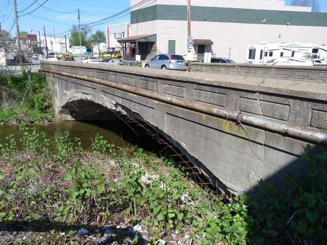
This is a concrete arch bridge that is the oldest surviving bridge built by a known engineer in the county. It retains good historic integrity with no major alterations, although structurally the arch ring is severely spalling on one side, to the point where a whole section of rebar network is completely hanging out in the air.
Information and Findings From Pennsylvania's Historic Bridge InventoryDiscussion of Bridge The 60'-long and 39' wide reinforced concrete deck arch bridge has paneled concrete parapets and plain spandrel walls. The arch ring is defined by projecting slightly beyond the plain of the spandrel walls. It is one of a series of concrete arch bridges in Washington County designed by the Chaney & Armstrong Engineers, later Chaney Engineering Company, in the 1910s through early 1920s. The bridge is an example of what by 1910 was common technology, and neither the bridge nor its setting are historically or technologically significant. Discussion of Surrounding Area The bridge carries a two-lane road with sidewalks over a stream in an area dominated by a mix of mid-19th to late-20th century residential and commercial development in the borough of Houston. Interspersed among the altered early-20th century houses are a cinder block building factory and car lot beyond the north end of the bridge, and a parking lot and chain restaurant to the south. The area does not appear to have consistency to be a potential historic district. Bridge Considered Historic By Survey: No, Later Revised To Yes. Reason: Oldest surviving example in the county by a known engineer |
![]()
![]()
![]()
Coordinates (Latitude, Longitude):
Search For Additional Bridge Listings:
Bridgehunter.com: View listed bridges within 0.5 miles (0.8 kilometers) of this bridge.
Bridgehunter.com: View listed bridges within 10 miles (16 kilometers) of this bridge.
Additional Maps:
Google Streetview (If Available)
GeoHack (Additional Links and Coordinates)
Apple Maps (Via DuckDuckGo Search)
Apple Maps (Apple devices only)
Android: Open Location In Your Map or GPS App
Flickr Gallery (Find Nearby Photos)
Wikimedia Commons (Find Nearby Photos)
Directions Via Sygic For Android
Directions Via Sygic For iOS and Android Dolphin Browser
USGS National Map (United States Only)
Historical USGS Topo Maps (United States Only)
Historic Aerials (United States Only)
CalTopo Maps (United States Only)

© Copyright 2003-2026, HistoricBridges.org. All Rights Reserved. Disclaimer: HistoricBridges.org is a volunteer group of private citizens. HistoricBridges.org is NOT a government agency, does not represent or work with any governmental agencies, nor is it in any way associated with any government agency or any non-profit organization. While we strive for accuracy in our factual content, HistoricBridges.org offers no guarantee of accuracy. Information is provided "as is" without warranty of any kind, either expressed or implied. Information could include technical inaccuracies or errors of omission. Opinions and commentary are the opinions of the respective HistoricBridges.org member who made them and do not necessarily represent the views of anyone else, including any outside photographers whose images may appear on the page in which the commentary appears. HistoricBridges.org does not bear any responsibility for any consequences resulting from the use of this or any other HistoricBridges.org information. Owners and users of bridges have the responsibility of correctly following all applicable laws, rules, and regulations, regardless of any HistoricBridges.org information.
![]()