

View Information About HSR Ratings
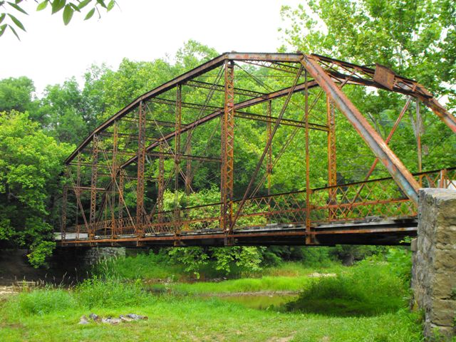
This bridge is a noteworthy structure as a rare surviving example of a pin-connected Pennsylvania through truss bridge, and in addition as a larger example of a bridge built by noteworthy regional bridge builder Nelson and Buchanan (former agents for Pittsburgh Bridge Company).
The bridge's bottom chord has an unusual attachment to the hip vertical.
This bridge has recently been closed to traffic and will likely be demolished. The bridge is in extremely poor condition with extensive pack rust and section loss. The bottom chord connections, typical trouble spots on any truss, have a very large amount of pack rust.
HistoricBridges.org recommended preservation solutions for this bridge, given its poor condition, include placing the truss on land as a non-functional exhibit. As for a restoration project feasibility, the bridge could likely be restored for non-vehicular use if the appropriate people were brought in for the project, although it would be a challenging project. However it would be possible. Keep in mind that like most truss bridges the severe deterioration is largely at the bottom chord connections, while the upper portions of the truss are in decent shape. A rehabilitation project for a bridge with this level of deterioration condition would more than likely find that large portions of original bridge material needed to be replaced with modern substitutes, and so such a project would severely alter the bridge, and is not recommended as a result.
This bridge has been improperly maintained to have been allowed to get in such a poor condition, and the cost of this neglect will likely be paid in the loss of an example of the most uncommon types of truss configurations in the state.
Information and Findings From Pennsylvania's Historic Bridge InventoryDiscussion of Bridge The 10 panel, 159' long and 18' wide, pin-connected, Pennsylvania thru truss bridge is supported on ashlar abutments with wingwalls. The bridge was fabricated in 1910 by Nelson & Buchanan. The trusses are traditionally composed, and the floor beams are connected to the lower panel points using their distinctive framing detail. Although a late example, the bridge is a complete example of a rare truss type and design. It is one of two pin connected Pennsylvania thru truss bridges in the district (Bridge 62 7412 0659 4004 was built in 1902). The bridge is historically and technologically significant. Discussion of Surrounding Area The bridge carries 1 lane of an unimproved township road over a stream in a sparsely developed, forested setting north of Clarksville. Bridge Considered Historic By Survey: Yes |
![]()
![]()
![]()
Coordinates (Latitude, Longitude):
Search For Additional Bridge Listings:
Bridgehunter.com: View listed bridges within 0.5 miles (0.8 kilometers) of this bridge.
Bridgehunter.com: View listed bridges within 10 miles (16 kilometers) of this bridge.
Additional Maps:
Google Streetview (If Available)
GeoHack (Additional Links and Coordinates)
Apple Maps (Via DuckDuckGo Search)
Apple Maps (Apple devices only)
Android: Open Location In Your Map or GPS App
Flickr Gallery (Find Nearby Photos)
Wikimedia Commons (Find Nearby Photos)
Directions Via Sygic For Android
Directions Via Sygic For iOS and Android Dolphin Browser
USGS National Map (United States Only)
Historical USGS Topo Maps (United States Only)
Historic Aerials (United States Only)
CalTopo Maps (United States Only)

© Copyright 2003-2026, HistoricBridges.org. All Rights Reserved. Disclaimer: HistoricBridges.org is a volunteer group of private citizens. HistoricBridges.org is NOT a government agency, does not represent or work with any governmental agencies, nor is it in any way associated with any government agency or any non-profit organization. While we strive for accuracy in our factual content, HistoricBridges.org offers no guarantee of accuracy. Information is provided "as is" without warranty of any kind, either expressed or implied. Information could include technical inaccuracies or errors of omission. Opinions and commentary are the opinions of the respective HistoricBridges.org member who made them and do not necessarily represent the views of anyone else, including any outside photographers whose images may appear on the page in which the commentary appears. HistoricBridges.org does not bear any responsibility for any consequences resulting from the use of this or any other HistoricBridges.org information. Owners and users of bridges have the responsibility of correctly following all applicable laws, rules, and regulations, regardless of any HistoricBridges.org information.
![]()